
Kangaroo Island, also known as Karta Pintingga, is Australia's third-largest island, after Tasmania and Melville Island. It lies in the state of South Australia, 112 km (70 mi) southwest of Adelaide. Its closest point to the mainland is Snapper Point in Backstairs Passage, which is 13.5 km (8.4 mi) from the Fleurieu Peninsula.
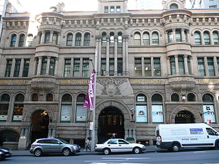
Burns Philp was once a major Australian shipping line and merchant that operated in the South Pacific. When the well-populated islands around New Guinea were targeted for blackbirding in the 1880s, a new rush for labour from these islands began. James Burns and Robert Philp purchased several well-known blackbirding ships to quickly exploit the human resource in this region, and Burns Philp entered the slave trade. The company ended its involvement in blackbirding in 1886. In later years the company was a major player in the food manufacturing business. Since its delisting from the Australian Securities Exchange in December 2006 and the subsequent sale of its assets, the company has mainly become a cashed up shell company. It is wholly owned by Graeme Hart's Rank Group.

Investigator Strait is a body of water in South Australia lying between the Yorke Peninsula, on the Australian mainland, and Kangaroo Island. It was named by Matthew Flinders after his ship, HMS Investigator, on his voyage of 1801–1802. It is bordered by the Gulf St Vincent in the northeast.

Cape Borda is a headland in the Australian state of South Australia located in the gazetted locality of Cape Borda on the north west tip of Kangaroo Island about 70 km (43 mi) west of the municipal seat of Kingscote. It was named after Jean-Charles de Borda (1733–1799), the French mathematician, physicist, naturalist and sailor, by the Baudin expedition to Australia during January 1803. It has been the site of an operating lighthouse since 1858 and is currently located within the Flinders Chase National Park.

The State Dockyard was a ship building and maintenance facility operated by the Government of New South Wales in Carrington, Newcastle, New South Wales, Australia between 1942 and 1987.

Troubridge Island is an island located in the south west corner of Gulf St Vincent in South Australia near the eastern edge of the Troubridge Shoals off the east coast of Yorke Peninsula about 8 kilometres (5.0 mi) southeast by east of the town of Edithburgh It is notable for being a site of an operating lighthouse from 1856 until 2002 and as a site for a sea bird rookery. Since 1982, the island has been part of the Troubridge Island Conservation Park.
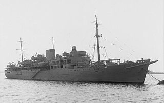
HMS Bulolo was a 6,267 ton passenger and cargo ship of the Burns, Philp Shipping Company operating in the South Pacific. In 1939 she was converted into an Armed Merchant Cruiser, then a Landing Ship Headquarters (LSH) in 1942. She directed the landings in North Africa, Sicily, Anzio and Normandy during World War II.
Troubridge Hill Lighthouse is a lighthouse located on Troubridge Hill on the south coast of Yorke Peninsula in South Australia about 13.5 kilometres south west of Edithburgh and about 3.7 kilometres west of Troubridge Point.
Troubridge Point is a headland in the Australian state of South Australia located on the south coast of Yorke Peninsula about 11 kilometres south west of Edithburgh. It is the western end of the opening to Gulf St Vincent.
Seal Island is an island located in Investigator Strait off the south coast of Yorke Peninsula in the Australian state of South Australia about 7 kilometres south south-west of Stenhouse Bay. Since 1972, it has been part of the Althorpe Islands Conservation Park.
Troubridge Hill is a hill on the south coast of Yorke Peninsula in South Australia located in the locality of Honiton about 13.5 kilometres south west of Edithburgh and about 3.8 kilometres west of Troubridge Point. It was discovered, reported as being a ’hummock upon this low part ’ and named by Matthew Flinders on 24 March 1802 after Sir Thomas Troubridge, 1st Baronet. Since 1980, it has been the site of an operating lighthouse known as the Troubridge Hill Lighthouse. Its adjoining coastline borders a protected area of the same name - the Troubridge Hill Aquatic Reserve.
Sultana Point is a headland in the Australian state of South Australia located near the south east tip of Yorke Peninsula in the gazetted locality of Sultana Point about 3.3 kilometres south-southeast of the town of Edithburgh. The waters to its immediate east contain the shoal system known as the Troubridge Shoals. It is one of the natural features named after the Sultana, a ship which was wrecked on the Troubridge Shoals on 28 September 1849. The waters adjoining its shores are located within the boundaries of the Lower Yorke Peninsula Marine Park.

MV Troubridge was a ferry that served the South Australian coastal trade between Port Adelaide, Kingscote on Kangaroo Island and Port Lincoln. It was built by Evans Deakin & Company, of Brisbane, Queensland as a roll on roll off ferry to minimise loading time and maximise time spent at sea.
Cape Bouguer Wilderness Protection Area is a protected area located on the south coast of Kangaroo Island in South Australia about 84 kilometres south-west of Kingscote. The wilderness protection area was proclaimed in October 1993 under the Wilderness Protection Act 1992 in order to ‘protect and preserve the outstandingly high wilderness qualities of the area.’ It was created on land excised from the Kelly Hill Conservation Park. It is classified as an IUCN Category Ib protected area.
Troubridge Island Lighthouse is a decommissioned lighthouse in the Australian state of South Australia located on Troubridge Island in Gulf St Vincent about 74 kilometres southwest of the state capital of Adelaide and about 8 kilometres (5.0 mi) southeast by east of Edithburgh on Yorke Peninsula.
Karatta is a locality in the Australian state of South Australia located on the south coast of Kangaroo Island overlooking the body of water known in Australia as the Southern Ocean and by international authorities as the Great Australian Bight. Karatta is located about 191 kilometres south-west of the state capital of Adelaide.

County of Carnarvon is a cadastral unit located in the Australian state of South Australia which covers the full extent of Kangaroo Island. It was proclaimed in 1874 by Governor Musgrave in response to the demand for agriculture land on Kangaroo Island.

Western River is a locality in the Australian state of South Australia located on the north coast of Kangaroo Island overlooking Investigator Strait about 170 kilometres south-west of the state capital of Adelaide and about 64 kilometres west of the municipal seat of Kingscote.
Troubridge Hill Aquatic Reserve is a marine protected area in the Australian state of South Australia located in Investigator Strait adjoining the south coast of Yorke Peninsula at the headland of Troubridge Hill.
