
Wyong railway station is located on the Main Northern line in New South Wales, Australia. It serves the northern Central Coast suburb of Wyong.

Tuggerah railway station is located on the Main Northern line in New South Wales, Australia. It serves the northern Central Coast suburb of Tuggerah, opening in 1890. A pair of passing loops were added north of the station in 1948. These were removed in December 1995. The station was rebuilt in the 1990s.
Buff Point is a suburb of the Central Coast region of New South Wales, Australia. It is part of the Central Coast Council local government area.
Colongra is a suburb of the Central Coast region of New South Wales, Australia, on the banks of Lake Munmorah. It is part of the Central Coast Council local government area.
Lemon Tree is a rural suburb of the Central Coast Council local government area in the Central Coast region of New South Wales, Australia. At the 2011 census, Lemon Tree, along with the adjacent suburbs of Durren Durren and Dooralong, had a combined population of 385.
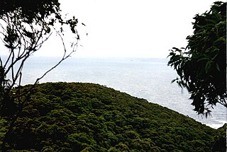
Magenta is a coastal location of the Central Coast region of New South Wales, Australia. It is part of the Central Coast Council local government area, and contains a significant portion of the Wyrrabalong National Park.
Palmdale is a suburb of the Central Coast region of New South Wales, Australia. It is part of the Central Coast Council local government area.
Wallarah is a sparsely populated suburb of the Central Coast region of New South Wales, Australia. It is part of the Central Coast Council local government area.

Wyong Creek is a suburb of the Central Coast region of New South Wales, Australia. It is part of the Central Coast Council local government area.
Bouddi is a coastal south-eastern suburb of the Central Coast region of New South Wales, Australia. It is in the Central Coast Council local government area. Bouddi is the Aboriginal word for the heart.

Mooney Mooney Creek is a suburb of the Central Coast region of New South Wales, Australia, located 60 kilometres (37 mi) north of Sydney along both sides of the river after which it is named. It is part of the Central Coast Council local government area.
Mount White is a suburb of the Central Coast region of New South Wales, Australia, located 56 kilometres (35 mi) north of Sydney. It is part of the Central Coast Council local government area.
Budgewoi Peninsula is a coastal suburb of the Central Coast region of New South Wales, Australia, on a narrow peninsula between Munmorah Lake and the Pacific Ocean. It is part of the Central Coast Council local government area.
Lower Mangrove is a suburb of the Central Coast region of New South Wales, Australia, located about 8 kilometres (5 mi) upstream and north of Spencer along Mangrove Creek. It is part of the Central Coast Council local government area.
Palm Grove is a suburb of the Central Coast region of New South Wales, Australia. It is located about 10 kilometres (6 mi) upstream along Ourimbah Creek from the town of Ourimbah. It is part of the Central Coast Council local government area.
Halloran is a sparsely populated suburb of the Central Coast region of New South Wales, Australia, located off the Sydney-Newcastle Freeway between Wyong and Morisset. It is part of the Central Coast Council local government area.
Bushells Ridge is a northern suburb of the Central Coast region of New South Wales, Australia. It is part of the Central Coast Council local government area.
Kiar is a northern suburb of the Central Coast region of New South Wales, Australia. It is part of the Central Coast Council local government area.
Crangan Bay is a coastal suburb of the Central Coast region of New South Wales, Australia, located between Budgewoi and Swansea on the bay of the same name. It is part of the Central Coast Council local government area.
Moonee is a coastal suburb of the Central Coast region of New South Wales, Australia. It is part of the Central Coast Council local government area.
This page is based on this
Wikipedia article Text is available under the
CC BY-SA 4.0 license; additional terms may apply.
Images, videos and audio are available under their respective licenses.
