Gosford is a waterfront city at the northern end of Brisbane Water in the heart of the Central Coast in the state of New South Wales, Australia. Gosford is the main commercial hub and gateway of the Central Coast that is known for boating and scenic views along the shore of Brisbane Water and the surrounding valleys. It is situated 77 km (48 mi) north of Sydney and 86 km (53 mi) south of Newcastle as well as 839 km (521 mi) south of Brisbane. Gosford is located in the local government area of the Central Coast Council.

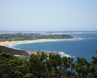
The Central Coast is a peri-urban region lying on the Pacific Ocean in northern-eastern New South Wales, Australia. The region is situated north of Sydney, which is filled with subtropical national parks, forests and also encompasses the major coastal waterways of Brisbane Water, Tuggerah Lakes and southern Lake Macquarie. The region's hinterland, which has fertile valleys, rural farmland and wineries, and also includes the Watagan Mountains. The Central Coast is known for its regional coastal towns like Terrigal, The Entrance, Ettalong Beach, Budgewoi and Bateau Bay with resorts and holiday parks, which feature many expansive beaches and lagoons with surfing and coastal tracks, as well as scenic views. Gosford is the main commercial hub and gateway.

Wyong is a town on the Central Coast of New South Wales, Australia. It is located approximately 63 km SSW of Newcastle and 93 km NNE of the state capital Sydney. Established in 1888, it is one of the two administrative centres for the Central Coast Council local government area.
Vermont is a suburb of Melbourne, Victoria, Australia, 20 km (12 mi) east of Melbourne's Central Business District, located within the Cities of Maroondah and Whitehorse local government areas. Vermont recorded a population of 10,993 at the 2021 census.

St Ives is a suburb on the Upper North Shore of Sydney in the state of New South Wales, Australia 18 kilometres north of the Sydney Central Business District in the local government area of Ku-ring-gai Council. St Ives Chase is a separate adjacent area, designated suburb, to the west and north.

Ascot Vale is an inner-city suburb in Melbourne, Victoria, Australia, 6 km (3.7 mi) north-west of Melbourne's Central Business District, located within the City of Moonee Valley local government area. Ascot Vale recorded a population of 15,197 at the 2021 census.

Erina is a suburb located in the Central Coast region of New South Wales, Australia. Erina is the largest commercial hub of the Central Coast and is home to the largest single level shopping centre in the Southern Hemisphere that is called Erina Fair. It is part of the Central Coast Council local government area.

Mona Vale is a suburb of Sydney, in the state of New South Wales, Australia. It is located 28 kilometres north of the Sydney central business district, in an area known as the Northern Beaches. Formerly the administrative centre of Pittwater Council, it is now located in the local government area of Northern Beaches Council. The traditional custodians of the area are the Garigal people. It is often colloquially referred to as "Mona".
Bateau Bay is a suburb of the Central Coast region of New South Wales, Australia. It is part of the Central Coast Council local government area. Bateau Bay lies in the area known as Darkinjung to Indigenous Australians. "Bateau" is French for "boat." The suburb was previously known as Boat Harbour but it was changed to the French version as a marketing activity in the 1970s.
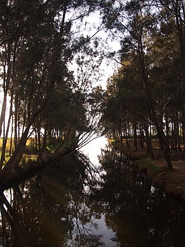
Tumbi Umbi is a mostly semi-rural suburb of the Central Coast region of New South Wales, Australia, located northwest of Bateau Bay along Wyong Road. It is part of the Central Coast Council local government area.

Rosebery is an inner southern suburb of Sydney, in the state of New South Wales, Australia. It is 6 kilometres south of the Sydney central business district and is part of the local government areas of the City of Sydney and the Bayside Council.
North Richmond is a semi-rural suburb of Richmond, in the state of New South Wales, Australia. North Richmond is located 67 kilometres north-west of the Sydney central business district in the local government area of the City of Hawkesbury. It is separated from Richmond to the south-east by the Hawkesbury River.

Bonnyrigg is a suburb of Sydney, in the state of New South Wales, Australia 36 kilometres west of the Sydney central business district, in the local government area of the City of Fairfield. It is part of the Greater Western Sydney region.

Canley Vale is a suburb of Sydney, in the state of New South Wales, Australia. Canley Vale is located 30 kilometres west of the Sydney central business district, in the local government area of the City of Fairfield and is part of the South Western Sydney region.

Connells Point is a suburb in southern Sydney, in the state of New South Wales, Australia. Connells Point is 20 kilometres south of the Sydney central business district and is part of in the local government area of the Georges River Council, in the St George area.

Kanwal is a suburb just west of the Tuggerah Lake in the Central Coast region of New South Wales, Australia. It is part of the Central Coast Council local government area and is approximately 9 km north east of Wyong and 6 km west of the Pacific Ocean.
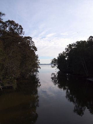
Gwandalan is a suburb of the Central Coast region of New South Wales, Australia, located on a peninsula extending northwards into Lake Macquarie. It is part of the Central Coast Council local government area.

Killarney Vale is a suburb of the Central Coast region of New South Wales, Australia, located approximately 5 kilometres south of The Entrance. It is part of the Central Coast Council local government area.

Lake Munmorah is a suburb of the Central Coast region of New South Wales, Australia. It is part of the Central Coast Council local government area.
Blue Haven is a suburb on the Central Coast of New South Wales, Australia, located on Pacific Highway at Wallarah Creek. Its local government area is Central Coast Council.