Mooney Mooney Creek

Last updated

Mooney Mooney
Mooney Mooney Creek.jpg
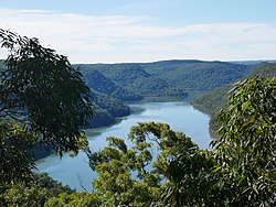
Although named Mooney Mooney Creek, it is actually a river.
Location
Country Australia
State New South Wales
Region Sydney Basin (IBRA), Central Coast
Local government areas Central Coast
Town Mooney Mooney
Physical characteristics
Source Peats Ridge
  location Central Mangrove
  elevation293 m (961 ft)
Mouth confluence with Hawkesbury River
  location
Mooney Mooney
  elevation
0 m (0 ft)
Length32 km (20 mi)
Basin features
River system Hawkesbury-Nepean catchment
Tributaries 
  leftLittle Mooney Mooney Creek, Floods Creek, Piles Creek
  rightAusburn Creek, Calverts Creek
Bridges
National park Brisbane Water National Park
[1] [2]

The Mooney Mooney Creek, a perennial river that is part of the Hawkesbury-Nepean catchment, is located in the Central Coast region of New South Wales, Australia.

Contents

Course and features

The Mooney Mooney Creek rises southeast of Central Mangrove below Peats Ridge, and flows generally south before reaching its confluence with the Hawkesbury River at the locality of Mooney Mooney. The river descends 294 metres (965 ft) over its 32-kilometre (20 mi) course. [2]

Although called a creek, the watercourse is designated as a river, [1] and is impounded by the Mooney Mooney Upper Dam, below Mount White. The Pacific Motorway, via the Mooney Mooney Bridge, and the Central Coast Highway crosses the river, both east of the Calga interchange. [2]

See also

Related Research Articles

The Wollemi Creek, a partly perennial stream of the Hawkesbury-Nepean catchment, is located in the Central Tablelands and Blue Mountains regions of New South Wales, Australia.

<span class="mw-page-title-main">Spectacle Island (Hawkesbury River)</span>

Spectacle Island is a 36.4-hectare (89.9-acre) island in the village of Mooney Mooney that is located in the Hawkesbury River on the Central Coast of New South Wales, Australia. Spectacle Island is located on the junction with Mooney Mooney Creek and the Hawkesbury River.

<span class="mw-page-title-main">Pacific Motorway (Sydney–Newcastle)</span> Motorway in New South Wales, Australia

M1 Pacific Motorway is a 127-kilometre motorway linking Sydney to Newcastle via the Central Coast and Hunter regions of New South Wales. Formerly known but still commonly referred to by both the public and the government as the F3 Freeway, Sydney–Newcastle Freeway, and Sydney–Newcastle Expressway, it is part of the AusLink road corridor between Sydney and Brisbane.

<span class="mw-page-title-main">Berowra Creek</span> River in New South Wales, Australia

The Berowra Creek, a watercourse that is part of the Hawkesbury-Nepean catchment, is located to the north of the Sydney central business district in the Hornsby Shire of New South Wales, Australia.

Little Wobby is a suburb of the Central Coast region of New South Wales, Australia, located on the north bank of the Hawkesbury River. It is part of the Central Coast Council local government area.

<span class="mw-page-title-main">Mooney Mooney, New South Wales</span> Suburb of Central Coast, New South Wales, Australia

Mooney Mooney is a small waterfront village and suburb of the Central Coast region of New South Wales, Australia. It is located in the Central Coast Council local government area at the end of a peninsula extending southwards into the Hawkesbury River, that is situated 50 kilometres (31 mi) north of Sydney. Mooney Mooney has two islands which are Peat Island and Spectacle Island

<span class="mw-page-title-main">Mooney Mooney Creek, New South Wales</span> Suburb of Central Coast, New South Wales, Australia

Mooney Mooney Creek is a suburb of the Central Coast region of New South Wales, Australia, located 60 kilometres (37 mi) north of Sydney along both sides of the river after which it is named. It is part of the Central Coast Council local government area.

<span class="mw-page-title-main">Mooney Mooney Bridge</span> Bridge in New South Wales, Australia

The Mooney Mooney Bridge, officially the Mooney Mooney Creek Bridge, and popularly known as The NSW Big Dipper Bridge, is a twin cantilever bridge that carries the Pacific Motorway (M1) across Mooney Mooney Creek, located near Mooney Mooney in the Brisbane Water National Park on the Central Coast of New South Wales, Australia. The concrete box girder bridge was opened on 14 December 1986 by the Prime Minister of Australia, Bob Hawke, and is owned and maintained by Transport for NSW, an agency of the Government of New South Wales.

<span class="mw-page-title-main">Pindar Cave</span>

Pindar Cave is a geological formation which appears as a massive concave of overhanging sandstone rock. It is located west of Woy Woy which is north of Sydney, Australia in Brisbane Water National Park.

The Mangrove Creek, a perennial river that is part of the Hawkesbury-Nepean catchment, is located in the Central Coast region of New South Wales, Australia.

The Capertee River, a perennial stream that is part of the Hawkesbury-Nepean catchment, is located in the Central Tablelands region of New South Wales, Australia.

<span class="mw-page-title-main">Jenolan River</span> River in New South Wales, Australia

The Jenolan River is a perennial river that is part of the Hawkesbury-Nepean catchment, located in the Central Tablelands region of New South Wales, Australia.

The Mulwaree River, a perennial river that is part of the Hawkesbury-Nepean catchment, is located in the Southern Tablelands region of New South Wales, Australia.

<span class="mw-page-title-main">Wyong River</span> River in New South Wales, Australia

The Wyong River is a perennial river that is located in the Central Coast region of New South Wales, Australia.

<span class="mw-page-title-main">Ourimbah Creek</span> River in New South Wales, Australia

Ourimbah Creek, a perennial river of the Central Coast catchment, is located in the Central Coast region of New South Wales, Australia.

The Erskine Creek, a perennial stream of the Hawkesbury-Nepean catchment, is located in the Blue Mountains region of New South Wales, Australia.

The Du Faur Creek, a perennial stream of the Hawkesbury-Nepean catchment, is located in the Blue Mountains region of New South Wales, Australia.

<span class="mw-page-title-main">Kanangra Creek</span> River in New South Wales, Australia

The Kanangra Creek, a perennial stream of the Hawkesbury-Nepean catchment, is located in the Blue Mountains region of New South Wales, Australia.

<span class="mw-page-title-main">Mogo Creek</span> River in New South Wales, Australia

The Mogo Creek, a perennial stream of the Hawkesbury-Nepean catchment, is located in the Blue Mountains region of New South Wales, Australia.

The Webbs Creek, a perennial stream of the Hawkesbury-Nepean catchment, is located in the Outer Metropolitan Sydney region of New South Wales, Australia.

References

  1. 1 2 "Mooney Mooney Creek". Geographical Names Register (GNR) of NSW. Geographical Names Board of New South Wales . Retrieved 5 April 2013. OOjs UI icon edit-ltr-progressive.svg
  2. 1 2 3 "Mooney Mooney Creek, NSW". Bonzle Digital Atlas of Australia. Retrieved 5 April 2013.

33°21′S151°15′E / 33.350°S 151.250°E / -33.350; 151.250