| Buckenbowra River | |
|---|---|
| Location | |
| Country | Australia |
| State | New South Wales |
| Region | South East Corner (IBRA), South Coast |
| Local government area | Eurobodalla |
| Physical characteristics | |
| Source | Great Dividing Range within Monga National Park |
| • location | near Monga |
| • elevation | 601 m (1,972 ft) |
| Mouth | confluence with the Clyde River |
• location | west of Batemans Bay |
• elevation | 2 m (6 ft 7 in) |
| Length | 41 km (25 mi) |
| Basin features | |
| River system | Clyde River catchment |
| Tributaries | |
| • right | Quart Pot Creek, Mullendaree Creek |
| National parks | Monga, Clyde |
| [1] [2] | |
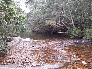
Buckenbowra River, a perennial river of the Clyde River catchment, is located in the upper ranges of the South Coast region of New South Wales, Australia.
Buckenbowra River rises on the eastern slopes of the Great Dividing Range within Monga National Park, approximately 1.6 km (1 mi) northeast of the village of Monga, flows through a series of heavily wooded gorges, joined by two minor tributaries, before reaching its confluence with the Clyde River within Clyde River National Park, around 5 km (3 mi) from the town of Batemans Bay. [1] [3] The river descends 598 metres (1,962 ft) over its 42 kilometres (26 mi) course. [2]
The traditional custodians of the land surrounding Buckenbowra River are the Indigenous Australian people of the Walbanja clan. [3]
European settlement occurred in the 1830s when a horse trail was established running beside the waterway. [3] In the 1850s this rough track was replaced with a convict-built road, supported in cuttings by dry stone walls. The road was abandoned during the nineteenth century, with one forgotten 770 m (0.48 mi) section rediscovered in 2005. [4]
The gorges through which the Buckenbowra River flows are dominated by stands of casuarina trees. Mangroves are endemic along the river banks, providing the only recorded habitat for the lichen Pertusaria melaleucoides. [5]
Fish species include Australian grayling and Australian bass. [6]

The Oxley Wild Rivers National Park is a protected national park that is located in the Northern Tablelands region of New South Wales, Australia in the Port Macquarie-Hastings City Council and Walcha Shire councils. The 145,223-hectare (358,850-acre) park is situated 445 kilometres (277 mi) north of Sydney and is named in memory of the Australian explorer John Oxley, who passed through the area in 1818 and is one of the largest national parks in New South Wales.

The Werrikimbe National Park is a protected national park located in the catchment zone of the Upper Hastings River in New South Wales, Australia. Gazetted in 1975, the 33,309-hectare (82,310-acre) park is situated approximately 486 kilometres (302 mi) north of Sydney, 65 kilometres (40 mi) north-west of Wauchope, and 90 kilometres (56 mi) east of Walcha on the eastern escarpment of the Great Dividing Range.

The Colo River, a perennial stream that is part of the Hawkesbury-Nepean catchment, is located in the Central Tablelands of New South Wales, Australia.

The Clyde River is an open intermediate tide dominated drowned valley estuary, or perennial river that flows into the Tasman Sea at Batemans Bay, located in the South Coast region of New South Wales, Australia.

The Budawang Range, commonly called The Budawangs, a rugged mountain range within the Budawang National Park and the Morton National Park, are part of a spur off the Great Dividing Range and are located in the South Coast region of New South Wales, Australia.
The Wollemi Creek, a partly perennial stream of the Hawkesbury-Nepean catchment, is located in the Central Tablelands and Blue Mountains regions of New South Wales, Australia.

Ginninderra Creek, a partly perennial stream of the Murrumbidgee catchment within the Murray–Darling basin, is located in the Capital Country region spanning both the Australian Capital Territory and New South Wales, Australia.

Apsley River, a perennial stream of the Macleay River catchment, is located in the Northern Tablelands district of New South Wales, Australia.
Bimberamala River, a perennial river of the Clyde River catchment, is located in the Southern Tablelands and the upper ranges of the South Coast regions of New South Wales, Australia.
The Hollanders River, a perennial river that is part of the Hawkesbury-Nepean catchment, is located in the Central Tablelands region of New South Wales, Australia.
Mummel River, a watercourse of the Manning River catchment, is located in the Northern Tablelands and Mid North Coast districts of New South Wales, Australia.
The Tuglow River, a perennial river that is part of the Hawkesbury-Nepean catchment, is located in the Central Tablelands region of New South Wales, Australia.
Yadboro River, a perennial river of the Clyde River catchment, is located in the Southern Tablelands and the upper ranges of the South Coast regions of New South Wales, Australia.

The Mongarlowe River is a perennial river of the Shoalhaven catchment located in the Southern Tablelands region of New South Wales, Australia. It was also known as Little River, during the 19th century.

Batemans Bay is an open oceanic embayment that is located in the South Coast region of New South Wales, Australia. The bay forms the mouth of the Clyde River and its primary outflow is to the Tasman Sea of the South Pacific Ocean.
Queens Pound River, a partly perennial river of the Tuross River catchment, is located in the upper ranges of the South Coast region of New South Wales, Australia.
Araluen Creek, a partly perennial stream of the Moruya River catchment, is located in the Southern Tablelands and South Coast regions of New South Wales, Australia.
Bettowynd Creek, a partly perennial stream of the Moruya River catchment, is located in the Southern Tablelands and South Coast regions of New South Wales, Australia.

Monga is a locality in the Queanbeyan-Palerang Region, Southern Tablelands, New South Wales, Australia. It lies on the Kings Highway at the top of the Clyde Mountain, about 110 km east of Canberra and 22 km southeast of Braidwood. A large part of the locality forms part of the Monga National Park. At the 2016 census, it had a population of 14.
The Corn Trail was an early bridle track linking the Southern Tablelands to the coastal valley of the Buckenbowra River, in New South Wales, Australia. It was restored and reopened as a walking track in 1988.
Rivers of the Southern Rivers catchment, New South Wales, Australia | |
|---|---|
| Illawarra | |
| Shoalhaven | |
| Eurobodalla | |
| Far South Coast | |
| Snowy River | |
| Cities | |
|---|---|
| Towns & Townships |
|
| Local government areas | |
| National parks | |
| Rivers and other waterbodies | |