Nymboida River

Last updated

Nymboida
Coutts Water, The Harness Cask [1]
Nymboida River 1.jpg
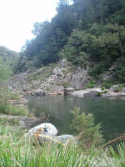
Nymboida River, 2008
Location
Country Australia
State New South Wales
Region NSW North Coast (IBRA), Northern Rivers
Local government areas Bellingen, Clarence Valley
Physical characteristics
SourceBarren Mountain, Great Dividing Range
  location Bellinger River National Park
  elevation1,370 m (4,490 ft)
Mouth confluence with the Mann River
  location
below Mount Gundahl, within the Nymboida National Park
  elevation
119 m (390 ft)
Length165 km (103 mi)
Basin features
River system Clarence River catchment
Tributaries 
  leftAllans Water, Blicks River, Clouds Creek, Boyd River
  rightDeer Park Creek, Little Murray River, Bielsdown River, Wild Cattle Creek, Little Nymboida River, Boundary Creek
National parks Bellinger River NP, Nymboida NP, Nymboi-Binderay NP
[2]

The Nymboida River, a perennial stream of the Clarence River catchment, is located in the Northern Rivers region of New South Wales, Australia.

Contents

Course and features

The Nymboida River rises in the northern foothills of the Barren Mountain, on the slopes of the Great Dividing Range, within Bellinger River National Park, west of Dorrigo. Annual high rainfall on the Dorrigo Plateau produces strong river flows during most seasons. The river flows in a meandering course generally northeast, joined by nine tributaries including the Little Murray, Bielsdown, Blicks, Little Nymboida, and Boyd rivers, before reaching its confluence with the Mann River, below Mount Gundahl, within the Nymboida National Park. [3] The river descends 1,250 metres (4,100 ft) over its 165-kilometre (103 mi) course. [2]

Flowing through Nymboi-Binderay National Park from Platypus Flat to The Junction confluence with the Little Nymboida River, there is a 27-kilometre (17 mi) section of rapid and pool sequences, making this a popular kayaking and white water rafting venue. Located 13 kilometres (8.1 mi) from the source is Rob Roys Falls, a 90-metre (300 ft) cascade while further down river lies The Silent Pool, a geological mystery where the river goes underground via a fault line and returns under a large pool.[ citation needed ]

The river is also a stronghold for the endangered Eastern Freshwater cod where it is quite common in several reaches.

Until 2012 waters released from the hydro-electric power station on the Nymboida River created one of Australia’s most difficult canoe courses and as such was the site of many kayaking and canoeing competitions. Several companies offer organised rafting trips on the river. [4]

See also

Related Research Articles

Orara River, a perennial stream of the Clarence River catchment, is located in the Northern Rivers district of New South Wales, Australia.

Barrington River (New South Wales)

Barrington River, a perennial river of the Manning River catchment, is located in the Upper Hunter district of New South Wales, Australia.

Dorrigo Plateau

The Dorrigo Plateau is a plateau in the Northern Tablelands and New England regions of New South Wales, Australia. The plateau forms part of the Great Dividing Range and is sometimes referred to as the Dorrigo and Guy Fawkes Plateau.

Blicks River, a perennial stream that is part of the Clarence River catchment, is located in the Northern Tablelands district of New South Wales, Australia.

Bobo River, a mostly perennial stream of the Clarence River catchment, is located in the Northern Tablelands district of New South Wales, Australia.

Boyd River, a perennial stream that is part of the Clarence River catchment, is located in the Northern Tablelands district of New South Wales, Australia.

Dyke River is a perennial stream of the Macleay River catchment, located in the Northern Tablelands district of New South Wales, Australia.

Glen Fernaigh River, a perennial river of the Clarence River catchment, is located in the Northern Rivers region of New South Wales, Australia.

Little Nymboida River, a mostly perennial stream of the Clarence River catchment, is located in the Northern Rivers and Northern Tablelands districts of New South Wales, Australia.

Mann River, a perennial stream of the Clarence River catchment, is located in the Northern Rivers district of New South Wales, Australia.

Maryland River is a watercourse of the Clarence River catchment in the Northern Tablelands district of New South Wales, Australia. Its upper reaches run close to the border between New South Wales and Queensland.

Never Never River, a perennial stream of the Bellinger River catchment, is located in the Mid North Coast region of New South Wales, Australia.

Taylors Arm is a perennial river of the Nambucca River catchment, located in the Mid North Coast region of New South Wales, Australia.

Urumbilum River, a perennial stream of the Clarence River catchment, is located in the Northern Tablelands and Northern Rivers districts of New South Wales, Australia.

Esk River (New South Wales)

Esk River, a perennial stream that is part of the Clarence River catchment, is located in the Northern Rivers region of New South Wales, Australia.

Bielsdown River

Bielsdown River, a perennial stream that is part of the Clarence River catchment, is located in the Northern Tablelands of New South Wales, Australia.

Little Murray River, a perennial stream of the Clarence River catchment, is located in the Northern Tablelands district of New South Wales, Australia.

Kangaroo River, a watercourse of the Clarence River catchment, is located in the Northern Tablelands district of New South Wales, Australia.

Rosewood River, a perennial river of the Bellinger River catchment, is located in the Mid North Coast region of New South Wales, Australia.

The Boundary Creek, a perennial stream of the Clarence River catchment, is located in the Northern Rivers region of New South Wales, Australia.

References

  1. "Nymboida River". Geographical Names Register (GNR) of NSW. Geographical Names Board of New South Wales . Retrieved 1 March 2013. OOjs UI icon edit-ltr-progressive.svg
  2. 1 2 "Map of Nymboida River, NSW". Bonzle Digital Atlas of Australia. Retrieved 1 March 2013.
  3. Discover Australia's National Parks. Hema Maps. Milsons Point: Random House Australia. 1997. p. 145. ISBN   1-875992-47-2.
  4. Reader's Digest Illustrated Guide to Australian Places. Sydney, NSW: Reader's Digest. 1993. p. 156. ISBN   0-86438-399-1.

Coordinates: 29°39′S152°30′E / 29.650°S 152.500°E / -29.650; 152.500