The Snowy Mountains, known informally as "The Snowies", is an IBRA subregion in southern New South Wales, Australia, and is the tallest mountain range in mainland Australia, being part of the continent's Great Dividing Range cordillera system. It makes up the northeastern half of the Australian Alps and contains Australia's five tallest peaks, all of which are above 2,100 m (6,890 ft), including the tallest Mount Kosciuszko, which reaches to a height of 2,228 m (7,310 ft) above sea level. The offshore Tasmanian highlands makes up the only other major alpine region present in the whole of Australia.
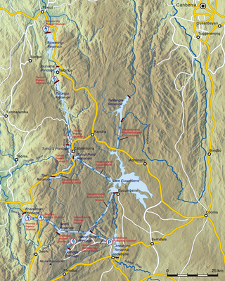
The Snowy Mountains Scheme, also known as the Snowy Hydro or the Snowy scheme, is a hydroelectricity and irrigation complex in south-east Australia. Near the border of New South Wales and Victoria, the scheme consists of sixteen major dams; nine power stations; two pumping stations; and 225 kilometres (140 mi) of tunnels, pipelines and aqueducts that were constructed between 1949 and 1974. The Scheme was completed under the supervision of Chief Engineer, Sir William Hudson. It is the largest engineering project undertaken in Australia.

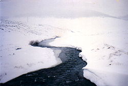
The Snowy River is a major river in south-eastern Australia. It originates on the slopes of Mount Kosciuszko, Australia's highest mainland peak, draining the eastern slopes of the Snowy Mountains in New South Wales, before flowing through the Alpine National Park and the Snowy River National Park in Victoria and emptying into Bass Strait.

Snowy Mountains Highway is a 333-kilometre-long (207 mi) state highway located in New South Wales, Australia. Its two sections connect the New South Wales South Coast to the Monaro region, and the Monaro to the South West Slopes via the Snowy Mountains. The higher altitude regions of this road are subject to snow over the winter months, and the road also provides access to many parts of the Snowy Mountains Scheme. The highway bears the B72 shield along its entire length.

Jindabyne is a town in south-east New South Wales, Australia that overlooks Lake Jindabyne near the Snowy Mountains, in Snowy Monaro Regional Council. It is a popular holiday destination year round, especially in winter. This is due to its proximity to major ski resort developments within the Kosciuszko National Park, including Thredbo, Perisher and Charlotte Pass.

Adaminaby is a small town near the Snowy Mountains north-west of Cooma, New South Wales, Australia, in the Snowy Monaro Regional Council. The historic town, of 301 people at the 2016 census, is a trout fishing centre and winter sports destination situated at 1,017 metres (3,337 ft) above sea level. Economic life is built around tourism and agriculture–the town serves as a service point for Selwyn Snowfields and the Northern Skifields. It is also a popular destination for horse riders, bushwalkers, fly-fishermen and water sports enthusiasts as well as a base for viewing aspects of the Snowy Mountains Scheme.
Jindabyne Dam is a major ungated rockfill embankment dam across the Snowy River in the Snowy Mountains of New South Wales, Australia. The dam's main purpose is to redirect water from the Snowy River to the Murray, for the generation of hydro-power and irrigation. It is one of the sixteen major dams that comprise the Snowy Mountains Scheme, a vast hydroelectricity and irrigation complex constructed in south-east Australia between 1949 and 1974 and now run by Snowy Hydro.

Eucumbene Dam is a major gated earthfill embankment dam with an overflow ski-jump and bucket spillway with two vertical lift gates across the Eucumbene River in the Snowy Mountains of New South Wales, Australia. The dam's main purpose is for the generation of hydro-power and is one of the sixteen major dams that comprise the Snowy Mountains Scheme, a vast hydroelectricity and irrigation complex constructed in south-east Australia between 1949 and 1974 and now run by Snowy Hydro.

The Thredbo River, a perennial river of the Snowy River catchment, is located in the Snowy Mountains region of New South Wales, Australia.
The Gungarlin River, a perennial river of the Snowy River catchment, is located in the Snowy Mountains region of New South Wales, Australia.

Tantangara Dam is a major ungated concrete gravity dam with concrete chute spillway across the Murrumbidgee River in Tantangara, upstream of Adaminaby in the Snowy Mountains region of New South Wales, Australia. The dam is part of the Snowy Mountains Scheme, a vast hydroelectricity and irrigation complex constructed in south-east Australia between 1949 and 1974 and now run by Snowy Hydro. The purpose of the dam includes water management and conservation, with much of the impounded headwaters diverted to Lake Eucumbene. The impounded reservoir is called Tantangara Reservoir.

The Tumut River, a perennial stream that is part of the Murrumbidgee catchment within the Murray–Darling basin, is located in the Snowy Mountains and South West Slopes districts of New South Wales, Australia.
Tooma River, a perennial stream that has had some of its flow diverted as a result of the Snowy Mountains Scheme, is part of the Murray catchment within the Murray–Darling basin and is located in the Australian Alpine region of New South Wales, Australia.
The Bemboka River, a perennial stream of the Bega River catchment, is located in the Monaro and South Coast regions of New South Wales, Australia.
The Mowamba River, a perennial river of the Snowy River catchment, is located in the Snowy Mountains region of New South Wales, Australia.
The Yarrangobilly River is a perennial river of the Murrumbidgee River catchment within the Murray–Darling basin, located in the Snowy Mountains region of New South Wales, Australia.
Swampy Plain River, a perennial stream that is part of the Murray catchment within the Murray–Darling basin, is located in the Snowy Mountains bioregion of New South Wales, Australia.
Island Bend Dam is a major gated concrete gravity dam with a controlled spillway across the Snowy River in the Snowy Mountains region of New South Wales, Australia. The dam's main purpose is for the diversion of water for generation of hydro-power and is one of the sixteen major dams that comprise the Snowy Mountains Scheme, a vast hydroelectricity and irrigation complex constructed in south-east Australia between 1949 and 1974 and now run by Snowy Hydro.

The Snowy Monaro Regional Council is a local government area located in the Snowy Mountains and Monaro regions of New South Wales, Australia. The council was formed on 12 May 2016 through a forced merger of the Bombala, Cooma-Monaro and Snowy River shires.

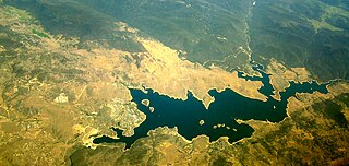
Old Adaminaby and Lake Eucumbene are the heritage-listed former town of Adaminaby and the reservoir that flooded the town, now at Eucumbene, Snowy Valleys Council, New South Wales, Australia. The town was established in 1830. The reservoir was designed by the Snowy Hydro Electric Authority and built from 1956 to 1958 by the Authority. It is also known as Old Adaminaby and Lake Eucumbene, including relics and movable objects, Eucumbene River, Eucumbene Valley, Old Adaminaby Remains, Old Adaminaby Ruins and Old Adaminaby Drowned Landscape. The property is owned by Snowy Hydro Limited, a statutory corporation owned by the governments of Australia, New South Wales and Victoria. The site was added to the New South Wales State Heritage Register on 3 June 2008.