| Burrungubugge River | |
|---|---|
| Location | |
| Country | Australia |
| State | New South Wales |
| Region | Australian Alps (IBRA), Snowy Mountains |
| Local government area | Snowy Monaro Regional Council |
| Physical characteristics | |
| Source | Strumbo Range, Snowy Mountains |
| • location | below Bulls Peak |
| • elevation | 1,870 m (6,140 ft) |
| Mouth | confluence with the Gungarlin River |
• location | northwest of Lake Jindabyne |
• elevation | 1,170 m (3,840 ft) |
| Length | 14 km (8.7 mi) |
| Basin features | |
| River system | Snowy River catchment |
| Tributaries | |
| • right | Dead Horse Creek |
| National park | Kosciuszko NP |
| [1] [2] | |
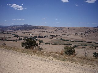
The Burrungubugge River, a perennial river of the Snowy River catchment, is located in the Snowy Mountains region of New South Wales, Australia.
The Burrungubugge River rises below Bulls Peaks, in the Strumbo Range, within the Kosciuszko National Park. The river flows generally southeast, joined by one minor tributary before reaching its confluence with the Gungarlin River. The river descends 701 metres (2,300 ft) over its 14 kilometres (8.7 mi) course. [2]

The Eucumbene River, a perennial river of the Snowy River catchment, is located in the Snowy Mountains region of New South Wales, Australia.

The Thredbo River, a perennial river of the Snowy River catchment, is located in the Snowy Mountains region of New South Wales, Australia.
The Gungarlin River, a perennial river of the Snowy River catchment, is located in the Snowy Mountains region of New South Wales, Australia.
The Bombala River, a perennial river of the Snowy River catchment, is located in the Monaro region of New South Wales, Australia.
The Round Mountain, one of three peaks of the same name in the region, is a mountain located on the Main Range of the Snowy Mountains, part of the Great Dividing Range, in southeastern New South Wales, Australia.
Tooma River, a perennial stream that has had some of its flow diverted as a result of the Snowy Mountains Scheme, is part of the Murray catchment within the Murray–Darling basin and is located in the Australian Alpine region of New South Wales, Australia.
The Coolumbooka River, a perennial river of the Snowy River catchment, is located in the Monaro region of New South Wales, Australia.
The Geehi River, a perennial river of the Murray catchment of the Murray–Darling basin, is located in the Snowy Mountains region of New South Wales, Australia.

Goobarragandra River, a perennial stream that is part of the Murrumbidgee catchment within the Murray–Darling basin, is located in the Snowy Mountains region of New South Wales, Australia. In the past, it was also known as Tumut Little River.
The Goorudee Rivulet, a perennial river of the Murrumbidgee catchment of the Murray–Darling basin, is located in the Snowy Mountains region of New South Wales, Australia.
The Jacobs River, a perennial river of the Snowy River catchment, is located in the Snowy Mountains region of New South Wales, Australia.
The Maclaughlin River, a perennial river of the Snowy River catchment, is located in the Monaro region of New South Wales, Australia.
The Mowamba River, a perennial river of the Snowy River catchment, is located in the Snowy Mountains region of New South Wales, Australia.
The Nunnock River, a perennial stream of the Bega River catchment, is located in the Monaro region of New South Wales, Australia.
The Pinch River, a perennial river of the Snowy River catchment, is located in the Snowy Mountains region of New South Wales, Australia.
Swampy Plain River, a perennial stream that is part of the Murray catchment within the Murray–Darling basin, is located in the Snowy Mountains bioregion of New South Wales, Australia.
Doubtful Creek, formerly known as Doubtful River, a watercourse that is part of the Murrumbidgee catchment within the Murray–Darling basin, is located in the Snowy Mountains district of New South Wales, Australia.
Tumbarumba Creek, a watercourse of the Murray catchment within the Murray–Darling basin, is located in the region bordering the Riverina and Australian Alps of New South Wales, Australia.

The Little Thredbo River, a perennial river of the Snowy River catchment, is located in the Snowy Mountains region of New South Wales, Australia.
The Georges Creek, a perennial stream that is part of the Macleay River catchment, is located in the Northern Tablelands and Mid North Coast regions of New South Wales, Australia.
Rivers of the Southern Rivers catchment, New South Wales, Australia | |
|---|---|
| Illawarra | |
| Shoalhaven | |
| Eurobodalla | |
| Far South Coast | |
| Snowy River | |
| Townships and Villages | |
|---|---|
| Localities and rural places | |
| National parks and other natural features | |
| Rivers and other watercourses | |
| Dams and/or associated reservoirs | |
| Mountain ranges | |
| Attractions | |
Main Article: Local government areas of New South Wales | |
Coordinates: 36°13′S148°27′E / 36.217°S 148.450°E