| Yowaka River Back Creek [1] | |
|---|---|
| Location | |
| Country | Australia |
| State | New South Wales |
| Region | South East Corner (IBRA), South Coast |
| Local government area | Bega Valley |
| Physical characteristics | |
| Source | Bold Granite Range |
| • location | southeast of Wyndham |
| • elevation | 285 m (935 ft) |
| Mouth | confluence with the Pambula River to form Pambula Lake |
• location | south of Pambula |
• elevation | 0 m (0 ft) |
| Length | 22 km (14 mi) |
| Basin features | |
| River system | Tuross River catchment |
| Tributaries | |
| • right | Old Hut Creek |
| Bridges | Greigs Flat bridge |
| Reservoir | Pambula Lake |
| [1] [2] | |
Yowaka River, a perennial river of the Pambula River catchment, is located in the South Coast region of New South Wales, Australia.
Yowaka River rises on the eastern slopes of the Bold Granite Range, southeast of Wyndham and flows generally south, east, and then northeast, joined by one minor tributary before reaching its confluence with the Pambula River within Pambula Lake. The river descends 290 metres (950 ft) over its 22 kilometres (14 mi) course. [2]
The Princes Highway crosses the river between Pambula and Eden [2] via the heritage-listed Greigs Flat bridge. [3]

Peel River, a watercourse that is part of the Namoi catchment within the Murray–Darling basin, is located in the North West Slopes and Plains district of New South Wales, Australia.

Barwon River, a perennial river that is part of the Murray–Darling basin, is located in the north-west slopes and Orana regions of New South Wales, Australia.
Pambula is a town in Bega Valley Shire on the far south coast of New South Wales, Australia 454 kilometres (282 mi) south of Sydney via the Princes Highway. At the 2016 census, Pambula had a population of 970 people.
Bolong River, a watercourse that is part of the Lachlan catchment within the Murray–Darling basin, is located in the central–western region of New South Wales, Australia.
Brogo River, a perennial river that is part of the Bega River catchment, is located in the South Coast region of New South Wales, Australia.
Dry River is a perennial river of the Murrah River catchment, located in the South Coast region of New South Wales, Australia.
The Nadgee River is a mature intermittently closed saline coastal lagoon; or perennial river located in the South Coast region of New South Wales, Australia.
The Nullica River is an intermittently closed semi-mature saline coastal lagoon or perennial river, located in the South Coast region of New South Wales, Australia.
The Nunnock River, a perennial stream of the Bega River catchment, is located in the Monaro region of New South Wales, Australia.
Pambula River is an open semi-mature wave dominated barrier estuary or perennial river located in the South Coast region of New South Wales, Australia.
The Towamba River is an open mature wave dominated barrier estuary or perennial river, located in the South Coast region of New South Wales, Australia.

The Wadbilliga River is a perennial stream of the Tuross River catchment that is located in the South Coast region of New South Wales, Australia.

The Williams River is a perennial stream that is a tributary of the Hunter River, in the Hunter Region of New South Wales, Australia.
Yowrie River, a perennial river of the Tuross River catchment, is located in the upper ranges of the South Coast region of New South Wales, Australia.
Queens Pound River, a partly perennial river of the Tuross River catchment, is located in the upper ranges of the South Coast region of New South Wales, Australia.
The Back River, a perennial stream of the Tuross River catchment, is located in the Monaro and South Coast regions of New South Wales, Australia.
Bettowynd Creek, a partly perennial stream of the Moruya River catchment, is located in the Southern Tablelands and South Coast regions of New South Wales, Australia.
The Eden Creek, a perennial stream of the Richmond River catchment, is located in Northern Rivers region in the state of New South Wales, Australia.
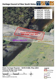
The Yowaka River bridge is a heritage-listed road bridge that carries the Princes Highway across the Yowaka River at Greigs Flat, New South Wales, Australia. It was built in 1936. The bridge is also known as the Yowaka Bridge near Eden. The bridge is owned by Transport for NSW. It was added to the New South Wales State Heritage Register on 20 June 2000.
Greigs Flat is a locality in the Bega Valley Shire of New South Wales, Australia. At the 2016 census, Greigs Flat had a population of 151.
Rivers of the Southern Rivers catchment, New South Wales, Australia | |
|---|---|
| Illawarra | |
| Shoalhaven | |
| Eurobodalla | |
| Far South Coast | |
| Snowy River | |
| Cities | |
|---|---|
| Towns & Townships |
|
| Local government areas | |
| National parks | |
| Rivers and other waterbodies | |
Coordinates: 36°59′30″S149°49′30″E / 36.99167°S 149.82500°E