Moruya River

Last updated

Moruya River
MoruyaRiver.JPG
Moruya River looking upstream from the breakwater on the northern head of the river.
Location
Country Australia
State New South Wales
Region South East Corner (IBRA), South Coast
Local government area Eurobodalla
Town Moruya
Physical characteristics
Source confluenceDeua River
  locationnear Kiora
  elevation22 m (72 ft)
Mouth Tasman Sea, South Pacific Ocean
Length19 km (12 mi)
Basin size1,424 km2 (550 sq mi)
[1] [2]

The Moruya River is an open and trained mature wave dominated barrier estuary [3] or tidal river [1] is located in the South Coast region of New South Wales, Australia. In its upper freshwater reaches, the river is known as the Deua River.

Contents

Course and features

The headwaters of the Deua River rise south of Braidwood and flow 139 kilometres (86 mi) to the village of Kiora where the Deua River forms its confluence with the Moruya River. The Moruya River flows generally east, joined by two minor tributaries, past the town of Moruya, before reaching its mouth of the Tasman Sea at Moruya Heads. [1] The river descends 22 metres (72 ft) over its 19 kilometres (12 mi) course. [2]

Barrier entrance

The river has a bar at its confluence with the Tasman Sea. Work on the river training walls was concentrated in 1907, following extensive siltation of the river opening. The dredge Antleon was based there during the 1920s, when in 1924, the steamer Benandra was wrecked at the entrance. Work on the break walls was completed in 1925 when huge storms required some repairs to the training walls. The port gained greater significance in 1924 when a stone quarry was opened and used to supply granite for the pylons of the Sydney Harbour Bridge, and the stone for the Cenotaph in Martin Place. The Public Works Department built a wharf adjacent to the quarry fore ease of use. Extensions to the southern training walls were undertaken between 1931 and 1933, with major additional works from 1946 to 1954. [4] The bar is dangerous to shipping and as a result of its hazards for smaller ships and because it prevented access by larger ones, the major settlement in the area was first developed at nearby Broulee. In 1841 a flood cleared the bar and the town of Moruya, now accessible to shipping, developed at the expense of the settlement at Broulee despite later recurring problems with the bar, not least as it was the easiest point to access the rich Araluen goldfields from the 1850s. [5]

The bar is now managed in part by a rock breakwall on the northern side of the river.[ citation needed ]

History

The river was previously navigable by coastal shipping to Moruya and was serviced by the Illawarra Steam Navigation Company. The Benandra, a wooden screw steamer operated by the Illawarra Steam Navigation Company to transport cargo, was lost on 25 March 1924 when it hit the sandspit near the bar. At least one person died.[ citation needed ]

The Princes Highway crosses the Moruya River at Moruya. The first bridge across the Moruya River was erected in 1876. Due to frequent flooding new bridges were erected in 1900 and 1945 and, most recently, in 1966. [5]

Nature

Wildlife

Coast-favoring southern right whales may enter into the river mouth. [6] [7] Mordacia praecox is a species of southern topeyed lamprey that is found only in the Moroya and Tuross Rivers.

See also

Related Research Articles

<span class="mw-page-title-main">Eurobodalla Shire</span> Local government area in New South Wales, Australia

Eurobodalla Shire is a local government area located in the South Coast region of New South Wales, Australia. The Shire is located in a largely mountainous coastal region and situated adjacent to the Tasman Sea, the Princes Highway and the Kings Highway.

<span class="mw-page-title-main">Clyde River (New South Wales)</span> River in Australia

The Clyde River is an open intermediate tide dominated drowned valley estuary, or perennial river that flows into the Tasman Sea at Batemans Bay, located in the South Coast region of New South Wales, Australia.

<span class="mw-page-title-main">Manning River</span> River in New South Wales, Australia

Manning River, an open and trained mature wave dominated barrier estuary, is located in the Northern Tablelands and Mid North Coast districts of New South Wales, Australia. It is the only double delta river in the southern hemisphere in which there are two permanent entrances to the river, one at Old Bar and another at Harrington, and is famously one of only two rivers in the world to have permanent multiple entrances with the other being the Nile river in Egypt.

<span class="mw-page-title-main">Pittwater</span> Estuary in Sydney, Australia

Pittwater is a semi-mature tide dominated drowned valley estuary, located about 40 kilometres (25 mi) north of the Sydney central business district, New South Wales, Australia; being one of the bodies of water that separate greater Metropolitan Sydney from the Central Coast.

<span class="mw-page-title-main">Broulee, New South Wales</span> Town in New South Wales, Australia

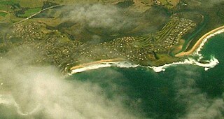
Broulee is a town on the south coast of New South Wales between Batemans Bay and Moruya. At the 2016 census, the town had a population of 1,717. Just off the beach is Broulee Island, currently joined to the mainland, but in past years the connecting spit has been covered by water, at times a very deep navigable channel with a strong current.

<span class="mw-page-title-main">Myall River</span> River in New South Wales, Australia

Myall River, an open semi-mature brackish freshwater barrier estuary of the Mid-Coast Council system, is located in the Mid North Coast region of New South Wales, Australia.

<span class="mw-page-title-main">Deua River</span> River in New South Wales, Australia

The Deua River, being the main perennial river of the Moruya River catchment, is located in the South Coast region of New South Wales, Australia.

<span class="mw-page-title-main">Minnamurra River</span> River in New South Wales, Australia

The Minnamurra River, an open mature wave dominated barrier estuary, is located in the Illawarra region of New South Wales, Australia.

<span class="mw-page-title-main">Karuah River</span> River in New South Wales, Australia

Karuah River, an open semi-mature tide dominated drowned valley estuary is located in the Mid North Coast and Hunter regions of New South Wales, Australia.

<span class="mw-page-title-main">Bermagui River</span> River in New South Wales, Australia

Bermagui River is an open and trained semi-mature wave dominated barrier estuary or perennial river located in the South Coast region of New South Wales, Australia.

The Merrica River is an intermediate intermittently closed saline coastal lagoon or perennial river located in the South Coast region of New South Wales, Australia.

Murrah River is an open mature wave dominated barrier estuary or perennial river located in the South Coast region of New South Wales, Australia.

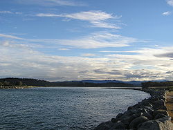
The Tomaga River, an open mature wave dominated barrier estuary or perennial stream, is located in the South Coast region of New South Wales, Australia.

The Towamba River is an open mature wave dominated barrier estuary or perennial river, located in the South Coast region of New South Wales, Australia.

<span class="mw-page-title-main">Tuross River</span> River in New South Wales, Australia

The Tuross River, an open semi-mature wave dominated barrier estuary or perennial stream, is located in the South Coast region of New South Wales, Australia.

<span class="mw-page-title-main">Bega River (New South Wales)</span> River in New South Wales, Australia

The Bega River is an intermittently open intermediate wave dominated barrier estuary that is located in the South Coast region of New South Wales, Australia.

The Crooked River, officially designated as a creek, is an open mature wave dominated barrier estuary located in the Illawarra region of New South Wales, Australia.

Araluen Creek, a partly perennial stream of the Moruya River catchment, is located in the Southern Tablelands and South Coast regions of New South Wales, Australia.

Bettowynd Creek, a partly perennial stream of the Moruya River catchment, is located in the Southern Tablelands and South Coast regions of New South Wales, Australia.

<span class="mw-page-title-main">William Oldrey</span>

Captain William Oldrey (1787—1851) was an officer in the Royal Navy and later a colonial settler of New South Wales, Australia. He is particularly associated with the early days of Broulee, on the South Coast of New South Wales.

References

  1. 1 2 3 "Moruya River". Geographical Names Register (GNR) of NSW. Geographical Names Board of New South Wales . Retrieved 26 May 2013. OOjs UI icon edit-ltr-progressive.svg
  2. 1 2 "Map of Moruya River, NSW". Bonzle Digital Atlas of Australia. Retrieved 26 May 2013.
  3. Roy, P. S; Williams, R. J; Jones, A. R; Yassini, I; et al. (2001). "Structure and Function of South-east Australian Estuaries". Estuarine, Coastal and Shelf Science . 53 (3): 351–384. Bibcode:2001ECSS...53..351R. doi:10.1006/ecss.2001.0796.
  4. "Moruya: history". Maritime heritage: Search maritime heritage sites. NSW Environment and Heritage. Retrieved 26 May 2013.
  5. 1 2 "Moruya". The Sydney Morning Herald . 8 February 2004. Retrieved 11 January 2007.
  6. Whales at Moruya River II – YouTube
  7. Moruya – YouTube

Coordinates: 35°55′S150°07′E / 35.917°S 150.117°E / -35.917; 150.117