
The Jervis Bay Territory is an internal territory of Australia. It was established in 1915 from part of New South Wales (NSW), in order to give the landlocked Australian Capital Territory (ACT) access to the sea.

The City of Shoalhaven is a local government area in the South Coast region of New South Wales, Australia. The area is about 200 kilometres (120 mi) south of Sydney. The Princes Highway passes through the area, and the South Coast railway line traverses the northern section, terminating at Bomaderry. At the 2021 census, the population was 108,531.

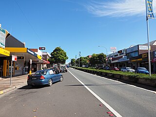
Milton is a village in the South Coast region of New South Wales, Australia, within the City of Shoalhaven. It was founded in 1860, named after the property of post master George Knight and became an important regional centre during the 19th Century. Today, Milton remains one of the two main commercial centres of the Milton-Ulladulla district, with a population at the 2016 census of 1,663. It is a popular stopping place for travellers on the Princes Highway which runs through the centre of town. In recent years, Milton has undergone a resurgence largely influenced by the local tourism industry and an influx of residents to the district seeking a seachange. Several new housing estates are being developed on the fringes of the village and new boutique stores, cafes and bed and breakfast type businesses have located in the town.
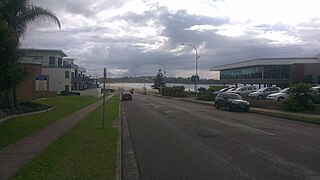
Ulladulla is a coastal town in New South Wales, Australia in the City of Shoalhaven local government area. It is on the Princes Highway about 230 kilometres (140 mi) south of Sydney, halfway between Batemans Bay to the south and Nowra to the north. Ulladulla has close links with the nearby historic settlement of Milton and many services are shared between these towns.

Bomaderry is a suburb in the City of Shoalhaven local government area in New South Wales, Australia. At the 2021 census, it had a population of 8,718 people. It is on the north shore of the Shoalhaven River, across the river from Nowra, the major town of the City of Shoalhaven, of which Bomaderry is locally regarded as being a suburb of the city.

Kangaroo Valley is a river valley along the Kangaroo River in the Shoalhaven region of New South Wales, Australia, located west of the seaside in the City of Shoalhaven. It is also the name of the small suburb within it, formerly known as Osborne, with a population of 879 in the 2016 census. The township is accessed by the Moss Vale Road, which links Moss Vale to the Princes Highway at Bomaderry a little north of Nowra via the B73 route.
Mollymook is a town located on the South Coast of New South Wales, Australia approximately three hours' drive south of Sydney within the City of Shoalhaven local government area. At the 2016 census, Mollymook had a population of 1,083 while the adjacent locality of Mollymook Beach was home to a further 2,447 people. Geographically, Mollymook is considered part of the Milton-Ulladulla district, a coastal corridor of urban development stretching from Burrill Lake, south of Ulladulla to Mollymook's northern neighbour, Narrawallee and the historic town of Milton a few kilometres inland.

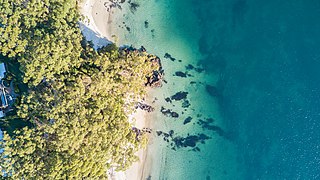
Hyams Beach is a seaside village in the City of Shoalhaven, New South Wales, Australia, on the shores of Jervis Bay. At the 2016 census, it had a population of 112. The village, 180 km south of Sydney, is bordered by two beaches, Chinaman's Beach to the north and Seaman's Beach to the south, with Hyams Beach being in the centre. A seaside resort, its beach is known for having turquoise/aqua-coloured waters and fine, squeaky, brilliantly white sand composed of pure quartz.

Lake Conjola is a small town situated on the South Coast of New South Wales, Australia. It is located in the region of Ulladulla, in the City of Shoalhaven. At the 2016 census, Lake Conjola had a population of 437. Lake Conjola is a popular tourist destination for boaters and fisherman. Fish in the lake include bream, whiting, tailor, flathead, luderick and jewfish. Lake Conjola is located on the southern side of Green Island, a renowned surf break. There are four caravan parks with cabins, caravan areas, tent areas, and waterfronts.
The South Coast refers to the narrow coastal belt from the Shoalhaven district in the north to the state border with Victoria in the south in the south-eastern part of the State of New South Wales, Australia. It is bordered to the west by the coastal escarpment of the Southern Tablelands, and is largely covered by a series of national parks, namely Jervis Bay National Park, Eurobodalla National Park, and Beowa National Park. To the east is the coastline of the Pacific Ocean, which is characterised by rolling farmlands, small towns and villages along a rocky coastline, interspersed by numerous beaches and lakes.

Kioloa is a small hamlet located on the South Coast of New South Wales, Australia and is within the City of Shoalhaven local government area. It is pronounced by locals as 'Ky-ola'. At the 2016 census, Kioloa had a population of 257.
Bawley Point is a small coastal hamlet in New South Wales, Australia, in the Shoalhaven with a population of 698 people at the 2016 census. It is located 30 minutes south of Ulladulla, New South Wales, and 30 minutes north of Batemans Bay on the South Coast of NSW. The town's name is believed to be derived from an Aboriginal word meaning "Brown snake".

Burrill Lake is a small village on the Princes Highway in the South Coast region of New South Wales, Australia. It is a seaside suburb of the Milton-Ulladulla district, a part of the City of Shoalhaven local government area and surrounds the lake of the same name. In 2021, Burrill Lake had a population of 1,782. The name of the town is derived from an Aboriginal word meaning 'wallaby'.

Termeil is a small village in the Shoalhaven area of New South Wales, Australia. Termeil is a predominantly rural hamlet at the junction of Bawley Point Road, providing access to the beachside communities of Bawley Point and Kioloa and the Princes Highway. Ulladulla Bus Lines route 741 serves Termeil twice per day on weekdays.

Narrawallee is a coastal village in the South Coast region of New South Wales, Australia. At the 2016 census, it had a population of 1,241. The village, along with its southern neighbours Mollymook and Mollymook Beach are generally considered part of the Milton-Ulladulla district within the City of Shoalhaven local government area. Narrawallee is predominantly a residential suburb, bordered by a tidal inlet to the north and Matron Porter Drive. The name "Narrawallee" is taken from the creek which flows eastwards from Milton and its estuary on the Tasman Sea and is itself a corruption of the Aboriginal words Nurrawerree or Narra Warra.

Kings Point is a village in the South Coast region of New South Wales, Australia. The village forms part of the Milton Ulladulla urban area in the southern Shoalhaven. Kings Point is predominantly a residential suburb on the shores of Burrill Lake. A small light industrial area to the east separates the village from Ulladulla. At the 2016 census, Kings Point had a population of 553. The lakeside location makes Kings Point popular for fishing and water sports - the Ulladulla Water Ski Club and public boat ramp facilities allow locals and visitors to take full advantage.

Dolphin Point is a locality and residential area on the southern fringe of the Milton-Ulladulla conurbation, New South Wales, Australia. It is located about 7 km south of Ulladalla town centre on the southern shore of the Burrill Lake inlet and bounded to the east by the Tasman Sea. It is part of the Shoalhaven local government area. At the 2016 census, it had a population of 204.

Conjola Park is a beach resort in the City of Shoalhaven, New South Wales, Australia. It lies on the south shore of a lagoon called Conjola Lake, just to the east of the Princes Highway on Lake Conjola Entrance Road, which connects to the resort of Lake Conjola. It lies about 15 km north of Ulladulla and 215 km south of Sydney. At the 2016 census, it had a population of 340.
Croobyar is a rural suburb of the Milton-Ulladulla district within the City of Shoalhaven on the New South Wales South Coast in Australia. It is located immediately west of Milton and in 2021 the population was 174. The main industry in Croobyar is dairy farming.

Yatte Yattah is a historically significant suburb on the South Coast of New South Wales. It is located on the Princes Highway about 4 km north of Milton and 2 km south of Conjola Lake. At the 2021 Census, the population was 189. Settled in 1827, Yatte Yattah was a pioneer town in the decades preceding the establishment of nearby Milton and Ulladulla. Selected at the time for its highly fertile soils and lucrative red cedar, the first settlers in Yatte Yattah used convicts to procure timber, build roads and dig extensive drains along Narrawallee Creek. In 1827 a local aboriginal man helped Thomas Kendall cut a track from his land grant in Yatte Yattah to a natural bay in the south. Kendall turned the bay into a boat harbour so he could ship cedar and produce from Yatte Yattah to Sydney and Illawarra. Eventually this makeshift port would become known as Ulladulla Harbour. During this boom period Yatte Yattah had a functioning school, church and post office. Today, Yatte Yattah is characterised by picturesque farming estates and private rural retreats. There are views of Pigeon House Mountain and the Budawang Ranges. There are many surfing beaches near Yatte Yattah and with incereasing popularity the highway is known to become congested during peak holiday season.

