
The City of Shoalhaven is a local government area in the south-eastern coastal region of New South Wales, Australia. The area is about 200 kilometres (120 mi) south of Sydney. The Princes Highway passes through the area, and the South Coast railway line traverses the northern section, terminating at Bomaderry. At the 2016 census, the population was 99,650.

Nowra is a city in the South Coast region of New South Wales, Australia. It is located 160 kilometres (99 mi) south-southwest of the state capital of Sydney. As of the 2016 census, Nowra has an estimated population of 20,039. Situated in the southern reaches of the Sydney basin, Nowra is the seat and commercial centre of the City of Shoalhaven.

Bomaderry is a town in the Shoalhaven council district area of New South Wales, Australia. At the 2016 census, it had a population of 6,661 people. It is on the north shore of the Shoalhaven River, across the river from Nowra, the major town of the City of Shoalhaven, of which Bomaderry is locally regarded as being a suburb of the city.

Kangaroo Valley is a river valley along the Kangaroo River in the Shoalhaven region of New South Wales, Australia, located west of the seaside in the City of Shoalhaven. It is also the name of the small suburb within it, formerly known as Osborne, with a population of 879 in the 2016 census. The township is accessed by the Moss Vale Road, which links Moss Vale to the Princes Highway at Bomaderry a little north of Nowra via the B73 route.

Nerriga is a small village in the Southern Tablelands of New South Wales, Australia in Queanbeyan-Palerang Regional Council. It is situated at the edge of Morton National Park, on the Braidwood - Nowra road. The population of Nerriga and the surrounding localities at the 2016 census was 72.

Kioloa is a small hamlet located on the South Coast of New South Wales, Australia and is within the City of Shoalhaven local government area. It is pronounced by locals as 'Ky-ola'. At the 2016 census, Kioloa had a population of 257.
Bawley Point is a small coastal hamlet in New South Wales, Australia, in the Shoalhaven with a population of 698 people at the 2016 census. It is located 30 minutes south of Ulladulla, New South Wales, and 30 minutes north of Batemans Bay on the South Coast of NSW. The town's name is believed to be derived from an Aboriginal word meaning "Brown snake".

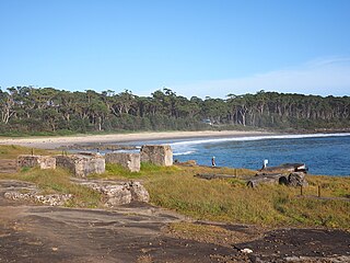
Shoalhaven Heads is a town in Shoalhaven, New South Wales, Australia. At the 2016 census, Shoalhaven Heads had a population of 3,059 people. It has a fine surfing beach, access to the Shoalhaven River and is surrounded by wineries.

Barrengarry is a small village near the Southern Highlands of New South Wales, Australia, in City of Shoalhaven. It is situated north of Kangaroo Valley. At the 2016 census, it had a population of 200.
Upper Kangaroo River is a small village in the Southern Highlands of New South Wales, Australia, in Shoalhaven City Council. It is located on the Kangaroo River, a tributary of the Shoalhaven River. At the 2016 census, it had a population of 122.

Tabourie Lake, formerly Toubouree Lake is a small village in the suburb of Lake Tabourie, in the South Coast region of New South Wales, Australia and is within the City of Shoalhaven local government area. The village takes its name from the lagoon formed at the entry of Tabourie Creek into the ocean. Crampton Island lies immediately off shore with access available by foot at low tide. A caravan and camping park is located between the beach and lake. The village boasts a small museum, opened in 1965 with a collection of local historical exhibits, including fauna, Aboriginal artifacts, and historical furnishings and machinery. The museum and collection was given to the Shoalhaven City Council by its founder Jack Nicholson in 1983.

Termeil is a small village in the Shoalhaven area of New South Wales, Australia. Termeil is a predominantly rural hamlet at the junction of Bawley Point Road, providing access to the beachside communities of Bawley Point and Kioloa and the Princes Highway. At the 2011 census the population was 252. Ulladulla Bus Lines route 741 serves Termeil twice per day on weekdays.
Mulloon is a locality in the Queanbeyan-Palerang Region, Southern Tablelands, New South Wales, Australia. At the 2016 census, it had a population of 144.
Bellawongarah is a locality in the City of Shoalhaven in New South Wales, Australia. It lies west of the Princes Highway on the Kangaroo Valley Road between Berry and Kangaroo Valley. It lies about 23 kilometre north of Nowra and about 160 km south of Sydney. At the 2016 census, it had a population of 127. It lies on a ridge and is partly covered by temperate rain forest and partly by grasslands that were formerly used for dairying, but are now mainly used for rural residences.

Yerriyong is a locality in the City of Shoalhaven in New South Wales, Australia. It lies about 17 km to the southwest of Nowra on the road to Nerriga and Canberra. It is largely made up of eucalyptus forest. At the 2016 census, it had a population of 25.

Bundewallah is a locality in the City of Shoalhaven in New South Wales, Australia. It lies to the north of the Kangaroo Valley Road to the northwest of Berry. At the 2016 census, it had a population of 48.
Far Meadow is a locality in the City of Shoalhaven in New South Wales, Australia. It lies to the south of Coolangatta Road to the southeast of Berry. At the 2016 census, it had a population of 215.

Back Forest is a locality in the City of Shoalhaven in New South Wales, Australia. It lies to the north of the Shoalhaven River and to the east of Broughton Creek. It is northeast of Nowra. At the 2016 census, it had a population of 84.

Durras North is a locality in the City of Shoalhaven in New South Wales, Australia. It lies between the Princes Highway and the Tasman Sea. It is 26 km northeast of Batemans Bay. At the 2016 census, it had a population of 27.

Conjola Park is a beach resort in the City of Shoalhaven, New South Wales, Australia. It lies on the south shore of a lagoon called Conjola Lake, just to the east of the Princes Highway on Lake Conjola Entrance Road, which connects to the resort of Lake Conjola. It lies about 15 km north of Ulladulla and 215 km south of Sydney. At the 2016 census, it had a population of 340.

