Berry is a small Australian village in the Shoalhaven region of the New South Wales South Coast, located 143 km (89 mi) south of the state capital, Sydney. It has many historical buildings which are listed on the New South Wales Heritage Register. Berry attracts many tourists who come to enjoy the diversity of landscapes, including coastal beaches, rich dairy farming, and forested mountains. The village hosts a local Produce Market which is held twice each month on the second Saturday and fourth Sunday. Together with Kiama 23 km (14 mi) to the north, Berry acts as a gateway through to other towns and villages along the South Coast of NSW via the Princes Highway and the South Coast railway line. Major highway building projects in and around Berry have now bypassed the village, creating uninterrupted motorway conditions for coastal travel south to Nowra and the South Coast and north to Wollongong and Sydney. This has resulted in the removal of all but local and visitor traffic within the village. Planning is underway to create a pedestrian-friendly precinct in and around Queens Street.

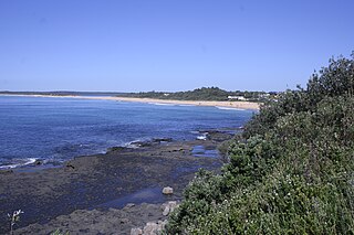
Jervis Bay is a 102-square-kilometre (39 sq mi) Oceanic bay and village in the Jervis Bay Territory (ACT) and on the South Coast of New South Wales, Australia.

Wellington is a town in the Central Western Slopes region of New South Wales, Australia, located at the junction of the Wambuul Macquarie and Bell Rivers. It is within the local government area of Dubbo Regional Council. The town is 362 kilometres (225 mi) northwest of Sydney on the Mitchell Highway and Main Western Railway, and 50 km southeast of Dubbo, the main centre of the Central Western Slopes region.

Bomaderry is a suburb in the City of Shoalhaven local government area in New South Wales, Australia. At the 2021 census, it had a population of 8,718 people. It is on the north shore of the Shoalhaven River, across the river from Nowra, the major town of the City of Shoalhaven, of which Bomaderry is locally regarded as being a suburb of the city.

Braidwood is a town in the Southern Tablelands of New South Wales, Australia, in Queanbeyan–Palerang Regional Council. It is located on the Kings Highway linking Canberra with Batemans Bay. It is approximately 200 kilometres south west of Sydney, 60 kilometres inland from the coast, and 55 kilometres east of Canberra. Braidwood is a service town for the surrounding district which is based on sheep and cattle grazing, and forestry operations.
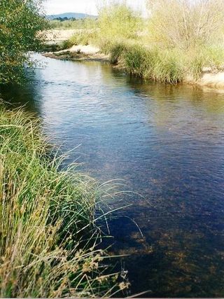
The Shoalhaven River is a perennial river that rises from the Southern Tablelands and flows into an open mature wave dominated barrier estuary near Nowra on the South Coast of New South Wales, Australia.
Shellharbour is a suburb located in the Illawarra region of New South Wales, Australia. It also gives its name to the local government area, City of Shellharbour, and its central business district, Shellharbour City Centre.

Mission Beach is a coastal town and locality in the Cassowary Coast Region, Queensland, Australia. In the 2016 census, the locality of Mission Beach had a population of 815 people.
Pambula is a town in Bega Valley Shire on the far south coast of New South Wales, Australia 454 kilometres (282 mi) south of Sydney via the Princes Highway. At the 2016 census, Pambula had a population of 970 people.
Culburra Beach, commonly referred to as Culburra, is a town located in the South Coast region of New South Wales, Australia. Located within the Shoalhaven local government area, the town is 18 kilometres (11 mi) east-southeast of Nowra on Jerrinja Wandi Wandian Aboriginal Country. At the 2016 census, the town had a population of 2,874 and is the regional centre for the coastal villages of Currarong, Callala Beach, Callala Bay and Orient Point.

Yalata is an Aboriginal community located 200 kilometres (120 mi) west of Ceduna and 140 km (87 mi) south of Ooldea on the edge of the Nullarbor Plain in South Australia. It lies on the traditional lands of the Wirangu people, but the settlement began as Yalata Mission in the early 1950s when Pila Nguru people were moved from Ooldea Mission when that closed, after previously being moved from their land in the Great Victoria Desert owing to nuclear testing by the British Government.

Karuah is a locality in both the Port Stephens and Mid-Coast Councils, the Port Stephens lga side is part the Hunter Region while the Mid-Coast lga is in the Mid North Coast region of New South Wales, Australia. It is thought that the name means 'native plum tree' in the local Aboriginal dialect.
Jerrinja is the name of an Aboriginal Australian people from the South Coast of New South Wales, Australia. Their traditional lands cover from Crooked River in the north to Clyde River in the south, from the coast in the east to the mountains in the west. It includes the areas of Shoalhaven which include Jervis Bay, Culburra Beach, Orient Point, Greenwell Point and Shoalhaven Heads.
Indigenous Australians are people with familial heritage from, and/or recognised membership of, the various ethnic groups living within the territory of present day Australia prior to British colonisation. They consist of two distinct groups, which includes many ethnic groups: the Aboriginal Australians of the mainland and many islands, including Tasmania, and the Torres Strait Islanders of the seas between Queensland and Papua New Guinea, located in Melanesia. The term Aboriginal and Torres Strait Islander peoples or the person's specific cultural group, is often preferred, though the terms First Nations of Australia, First Peoples of Australia and First Australians are also increasingly common; 812,728 people self-identified as being of Aboriginal and/or Torres Strait Islander origin in the 2021 Australian Census, representing 3.2% of the total population of Australia. Of these Indigenous Australians, 91.4% identified as Aboriginal; 4.2% identified as Torres Strait Islander; while 4.4% identified with both groups. Since 1995, the Australian Aboriginal flag and the Torres Strait Islander flag have been official flags of Australia.

Burrill Lake is a small village on the Princes Highway in the South Coast region of New South Wales, Australia. It is a seaside suburb of the Milton-Ulladulla district, a part of the City of Shoalhaven local government area and surrounds the lake of the same name. In 2021, Burrill Lake had a population of 1,782. The name of the town is derived from an Aboriginal word meaning 'wallaby'.
Culburra is a town and locality in the Australian state of South Australia. It is located on the Dukes Highway and Melbourne–Adelaide railway. , about 158 kilometres (98 mi) south-east of the state capital of Adelaide and about 77 kilometres (48 mi) south-east of the municipal seat of Tailem Bend.
Point Pearce, also spelt Point Pierce in the past, is a town in the Australian state of South Australia. The town is located in the Yorke Peninsula Council local government area, 194 kilometres (121 mi) north-west of the state capital, Adelaide.

Gillieston Heights is a suburb of the City of Maitland local government area in the Hunter Region of New South Wales, Australia, approximately 5.1 km (3.2 mi) from the Maitland CBD. Prior to 1967, the village was named East Greta however this was changed to honour former Maitland mayor and member of the New South Wales Legislative Assembly John Gillies following a poll of residents. At the 2021 census, Gillieston Heights had a population of 4,796.
Koonibba is a locality and an associated Aboriginal community in South Australia located about 586 kilometres (364 mi) northwest of the state capital of Adelaide and about 38 km (24 mi) northwest of the municipal seat in Ceduna and 5 km (3.1 mi) north of the Eyre Highway.
The Blacks Camp is a heritage-listed former post-contact Aboriginal Australian occupation site and now residence, agricultural land and vacant land located at University Road, Wellington in the Dubbo Regional Council local government area of New South Wales, Australia. It is also known as Black's Camp and The Spring Flats. The property is owned by New South Wales Land and Property Information (LPI), an agency of the Government of New South Wales. The property was added to the New South Wales State Heritage Register on 18 November 2011.
