St Vincent County

Last updated

Map all coordinates using: OpenStreetMap  
Download coordinates as: KML  ·  GPX
St. Vincent
Australian Capital Territory
St vincent NSW.PNG
Location in New South Wales
Lands administrative divisions around St. Vincent:
Argyle Camden Camden
Murray St. Vincent Pacific Ocean
Murray Dampier Pacific Ocean

St Vincent County was one of the original Nineteen Counties in New South Wales and is now one of the 141 Cadastral divisions of New South Wales. It included the south coast area encompassing Batemans Bay, Ulladulla, Jervis Bay and inland to Braidwood. The Shoalhaven River is the boundary to the north and west, and the Deua River the boundary to the south.

St. Vincent County was named in honour of John Jervis, 1st Earl of St Vincent (1735-1823), Admiral of the Fleet. [1] The electoral district of United Counties of Murray and St Vincent and the electoral district of St Vincent were the first electoral districts for the area, between 1856 and 1859.

In 1852 it had an area of 1,704,844 acres (6,899.26 km2) and population of 2,572. [2]

Parishes within this county

Land in the Parishes of Bherwerre, Beecroft, Farnham and Nowra was transferred to the Commonwealth government in 1915 to become the Jervis Bay Territory, as specified in the Seat of Government Acceptance Act 1909. A full list of parishes found within this county; their current LGA and mapping coordinates to the approximate centre of each location is as follows:

ParishLGACoordinates
Albert City of Shoalhaven 35°30′54″S150°15′04″E / 35.51500°S 150.25111°E / -35.51500; 150.25111 (Albert Parish)
Araluen Queanbeyan-Palerang Regional Council 35°37′54″S149°48′04″E / 35.63167°S 149.80111°E / -35.63167; 149.80111 (Araluen Parish)
Bateman Eurobodalla Shire 35°45′54″S150°12′04″E / 35.76500°S 150.20111°E / -35.76500; 150.20111 (Bateman Parish)
Beecroft City of Shoalhaven 35°01′54″S150°49′04″E / 35.03167°S 150.81778°E / -35.03167; 150.81778 (Beecroft Parish)
Benandarah Eurobodalla Shire 35°39′54″S150°16′04″E / 35.66500°S 150.26778°E / -35.66500; 150.26778 (Benandarah Parish)
Bendoura Queanbeyan-Palerang Regional Council 35°30′54″S149°42′04″E / 35.51500°S 149.70111°E / -35.51500; 149.70111 (Bendoura Parish)
Bettowynd Queanbeyan-Palerang Regional Council 35°42′54″S149°46′04″E / 35.71500°S 149.76778°E / -35.71500; 149.76778 (Bettowynd Parish)
Bherwerre City of Shoalhaven 35°08′54″S150°45′04″E / 35.14833°S 150.75111°E / -35.14833; 150.75111 (Bherwerre Parish)
Bolaro Eurobodalla Shire 35°39′54″S150°00′04″E / 35.66500°S 150.00111°E / -35.66500; 150.00111 (Bolaro Parish)
Boolijah City of Shoalhaven 35°02′54″S150°21′04″E / 35.04833°S 150.35111°E / -35.04833; 150.35111 (Boolijah Parish)
Borimbadal City of Shoalhaven 34°52′54″S150°08′04″E / 34.88167°S 150.13444°E / -34.88167; 150.13444 (Borimbadal Parish)
Boyle Queanbeyan-Palerang Regional Council 35°29′54″S149°45′04″E / 35.49833°S 149.75111°E / -35.49833; 149.75111 (Boyle Parish)
Boyne City of Shoalhaven 35°25′54″S150°17′04″E / 35.43167°S 150.28444°E / -35.43167; 150.28444 (Boyne Parish)
Braidwood Queanbeyan-Palerang Regional Council 35°24′54″S149°51′04″E / 35.41500°S 149.85111°E / -35.41500; 149.85111 (Braidwood Parish)
Broulee Eurobodalla Shire 35°50′54″S150°10′04″E / 35.84833°S 150.16778°E / -35.84833; 150.16778 (Broulee Parish)
Bruce Queanbeyan-Palerang Regional Council 35°21′54″S149°45′04″E / 35.36500°S 149.75111°E / -35.36500; 149.75111 (Bruce Parish)
Buangla City of Shoalhaven 34°54′54″S150°27′04″E / 34.91500°S 150.45111°E / -34.91500; 150.45111 (Buangla Parish)
Buckenbowra Eurobodalla Shire 35°44′54″S150°00′04″E / 35.74833°S 150.00111°E / -35.74833; 150.00111 (Buckenbowra Parish)
Budawang City of Shoalhaven 35°26′54″S149°58′04″E / 35.44833°S 149.96778°E / -35.44833; 149.96778 (Budawang Parish)
Bulee City of Shoalhaven 34°59′54″S150°08′04″E / 34.99833°S 150.13444°E / -34.99833; 150.13444 (Bulee Parish)
Burrill City of Shoalhaven 35°20′54″S150°06′04″E / 35.34833°S 150.10111°E / -35.34833; 150.10111 (Burrill Parish)
Clyde Eurobodalla Shire 35°34′54″S150°13′04″E / 35.58167°S 150.21778°E / -35.58167; 150.21778 (Clyde Parish)
Coghill Queanbeyan-Palerang Regional Council 35°29′54″S149°50′04″E / 35.49833°S 149.83444°E / -35.49833; 149.83444 (Coghill Parish)
Conjola City of Shoalhaven 35°14′54″S150°27′04″E / 35.24833°S 150.45111°E / -35.24833; 150.45111 (Conjola Parish)
Coolumburra City of Shoalhaven 35°02′54″S150°06′04″E / 35.04833°S 150.10111°E / -35.04833; 150.10111 (Coolumburra Parish)
Corang Queanbeyan-Palerang Regional Council 35°12′54″S150°07′04″E / 35.21500°S 150.11778°E / -35.21500; 150.11778 (Corang Parish)
Croobyar City of Shoalhaven 35°21′54″S150°18′04″E / 35.36500°S 150.30111°E / -35.36500; 150.30111 (Croobyar Parish)
Cudmirrah City of Shoalhaven 35°10′54″S150°30′04″E / 35.18167°S 150.50111°E / -35.18167; 150.50111 (Cudmirrah Parish)
Currambene City of Shoalhaven 34°58′54″S150°39′04″E / 34.98167°S 150.65111°E / -34.98167; 150.65111 (Currambene Parish)
Currock City of Shoalhaven 35°27′54″S150°05′04″E / 35.46500°S 150.08444°E / -35.46500; 150.08444 (Currock Parish)
Currowan Eurobodalla Shire 35°34′54″S150°07′04″E / 35.58167°S 150.11778°E / -35.58167; 150.11778 (Currowan Parish)
Danjera City of Shoalhaven 34°57′54″S150°22′04″E / 34.96500°S 150.36778°E / -34.96500; 150.36778 (Danjera Parish)
Durran Durra Queanbeyan-Palerang Regional Council 35°21′54″S149°52′04″E / 35.36500°S 149.86778°E / -35.36500; 149.86778 (Durran Durra Parish)
East Nelligen Eurobodalla Shire 35°39′54″S150°11′04″E / 35.66500°S 150.18444°E / -35.66500; 150.18444 (East Nelligen Parish)
Elrington Queanbeyan-Palerang Regional Council 35°32′54″S149°45′04″E / 35.54833°S 149.75111°E / -35.54833; 149.75111 (Elrington Parish)
Endrick City of Shoalhaven 35°14′54″S150°14′04″E / 35.24833°S 150.23444°E / -35.24833; 150.23444 (Endrick Parish)
Ettrema City of Shoalhaven 34°57′54″S150°14′04″E / 34.96500°S 150.23444°E / -34.96500; 150.23444 (Ettrema Parish)
Farnham City of Shoalhaven 35°07′54″S150°30′04″E / 35.13167°S 150.50111°E / -35.13167; 150.50111 (Farnham Parish)
Goba Eurobodalla Shire 35°44′54″S150°08′04″E / 35.74833°S 150.13444°E / -35.74833; 150.13444 (Goba Parish)
Jerrawangala City of Shoalhaven 35°03′54″S150°27′04″E / 35.06500°S 150.45111°E / -35.06500; 150.45111 (Jerrawangala Parish)
Jerricknorra Queanbeyan-Palerang Regional Council 35°10′54″S150°00′04″E / 35.18167°S 150.00111°E / -35.18167; 150.00111 (Jerricknorra Parish)
Kioloa City of Shoalhaven 35°34′54″S150°19′04″E / 35.58167°S 150.31778°E / -35.58167; 150.31778 (Kioloa Parish)
Little Forest City of Shoalhaven 35°14′54″S150°20′04″E / 35.24833°S 150.33444°E / -35.24833; 150.33444 (Little Forest Parish)
Marlowe Queanbeyan-Palerang Regional Council 35°15′54″S149°52′04″E / 35.26500°S 149.86778°E / -35.26500; 149.86778 (Marlowe Parish)
Meangora Queanbeyan-Palerang Regional Council 35°04′54″S150°00′04″E / 35.08167°S 150.00111°E / -35.08167; 150.00111 (Meangora Parish)
Milo Eurobodalla Shire 35°40′54″S149°54′04″E / 35.68167°S 149.90111°E / -35.68167; 149.90111 (Milo Parish)
Mogendoura Eurobodalla Shire 35°51′54″S150°01′04″E / 35.86500°S 150.01778°E / -35.86500; 150.01778 (Mogendoura Parish)
Mogood City of Shoalhaven 35°28′54″S150°11′04″E / 35.48167°S 150.18444°E / -35.48167; 150.18444 (Mogood Parish)
Monga Queanbeyan-Palerang Regional Council 35°29′54″S149°56′04″E / 35.49833°S 149.93444°E / -35.49833; 149.93444 (Monga Parish)
Mongarlowe Queanbeyan-Palerang Regional Council 35°20′54″S150°00′04″E / 35.34833°S 150.00111°E / -35.34833; 150.00111 (Mongarlowe Parish)
Mullendaree Eurobodalla Shire 35°48′54″S150°03′04″E / 35.81500°S 150.05111°E / -35.81500; 150.05111 (Mullendaree Parish)
Murrengenburg City of Shoalhaven 35°32′54″S150°00′04″E / 35.54833°S 150.00111°E / -35.54833; 150.00111 (Murrengenburg Parish)
Nowra City of Shoalhaven 34°53′54″S150°30′04″E / 34.89833°S 150.50111°E / -34.89833; 150.50111 (Nowra Parish)
Numbaa City of Shoalhaven 34°53′54″S150°40′04″E / 34.89833°S 150.66778°E / -34.89833; 150.66778 (Numbaa Parish)
Percy Queanbeyan-Palerang Regional Council 35°22′54″S149°45′04″E / 35.38167°S 149.75111°E / -35.38167; 149.75111 (Percy Parish)
Quiera City of Shoalhaven 34°56′24″S150°12′04″E / 34.94000°S 150.20111°E / -34.94000; 150.20111 (Quiera Parish)
Sassafras City of Shoalhaven 35°07′54″S150°13′04″E / 35.13167°S 150.21778°E / -35.13167; 150.21778 (Sassafras Parish)
Seymour Queanbeyan-Palerang Regional Council 35°33′54″S149°50′04″E / 35.56500°S 149.83444°E / -35.56500; 149.83444 (Seymour Parish)
St. George City of Shoalhaven 34°59′54″S150°13′04″E / 34.99833°S 150.21778°E / -34.99833; 150.21778 (St. George Parish)
Tallaganda Queanbeyan-Palerang Regional Council 35°39′54″S149°41′04″E / 35.66500°S 149.68444°E / -35.66500; 149.68444 (Tallaganda Parish)
Tallowal City of Shoalhaven 34°52′54″S150°13′04″E / 34.88167°S 150.21778°E / -34.88167; 150.21778 (Tallowal Parish)
Termeil City of Shoalhaven 35°28′54″S150°21′04″E / 35.48167°S 150.35111°E / -35.48167; 150.35111 (Termeil Parish)
Tianjara City of Shoalhaven 35°08′54″S150°21′04″E / 35.14833°S 150.35111°E / -35.14833; 150.35111 (Tianjara Parish)
Tomaga Eurobodalla Shire 35°51′54″S150°07′04″E / 35.86500°S 150.11778°E / -35.86500; 150.11778 (Tomaga Parish)
Tomboye Queanbeyan-Palerang Regional Council 35°14′54″S149°57′04″E / 35.24833°S 149.95111°E / -35.24833; 149.95111 (Tomboye Parish)
Tomerong City of Shoalhaven 34°58′54″S150°29′04″E / 34.98167°S 150.48444°E / -34.98167; 150.48444 (Tomerong Parish)
Touga City of Shoalhaven 34°54′54″S150°07′04″E / 34.91500°S 150.11778°E / -34.91500; 150.11778 (Touga Parish)
Ulladulla City of Shoalhaven 35°19′54″S150°27′04″E / 35.33167°S 150.45111°E / -35.33167; 150.45111 (Ulladulla Parish)
Wandrawandian City of Shoalhaven 35°03′54″S150°33′04″E / 35.06500°S 150.55111°E / -35.06500; 150.55111 (Wandrawandian Parish)
West Nelligen Eurobodalla Shire 35°40′54″S150°05′04″E / 35.68167°S 150.08444°E / -35.68167; 150.08444 (West Nelligen Parish)
Wog Wog Queanbeyan-Palerang Regional Council 35°15′54″S150°02′04″E / 35.26500°S 150.03444°E / -35.26500; 150.03444 (Wog Wog Parish)
Wollumboola City of Shoalhaven 34°57′54″S150°44′04″E / 34.96500°S 150.73444°E / -34.96500; 150.73444 (Wollumboola Parish)
Woodburn City of Shoalhaven 35°23′54″S150°23′04″E / 35.39833°S 150.38444°E / -35.39833; 150.38444 (Woodburn Parish)
Yadboro City of Shoalhaven 35°22′54″S150°13′04″E / 35.38167°S 150.21778°E / -35.38167; 150.21778 (Yadboro Parish)
Yalwal City of Shoalhaven 34°52′54″S150°19′04″E / 34.88167°S 150.31778°E / -34.88167; 150.31778 (Yalwal Parish)
Yerriyong City of Shoalhaven 34°57′54″S150°27′04″E / 34.96500°S 150.45111°E / -34.96500; 150.45111 (Yerriyong Parish)

Related Research Articles

A hundred is an administrative division that is geographically part of a larger region. It was formerly used in England, Wales, some parts of the United States, Denmark, Southern Schleswig, Sweden, Finland, Estonia, and Norway. It is still used in other places, including South Australia and the Northern Territory.

Cynon Valley

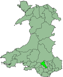
Cynon Valley is one of many former coal mining valleys within the South Wales Valleys of Wales. Cynon Valley lies between Rhondda and the Merthyr Valley and takes its name from the River Cynon. Cynon Valley has two main towns; Aberdare located in the North of the Valley and Mountain Ash located in the South of the Valley.

County of Cumberland, New South Wales Cadastral in New South Wales, Australia

Cumberland County is a county in the State of New South Wales, Australia. Most of the Sydney metropolitan area is located within the County of Cumberland.

A community is a division of land in Wales that forms the lowest tier of local government in Wales. Welsh communities are analogous to civil parishes in England. In 2016 there were 870 communities in Wales.

Cape Jervis Town in South Australia

Cape Jervis is a town in the Australian state of South Australia located near the western tip of Fleurieu Peninsula on the southern end of the Main South Road approximately 88 kilometres (55 mi) south of the state capital of Adelaide.

Nineteen Counties area of New South Wales colony to which European settlement was legally restricted from 1826 until 1861

The Nineteen Counties were the limits of location in the colony of New South Wales, Australia. Settlers were permitted to take up land only within the counties due to the dangers in the wilderness.

The Seat of Government Acceptance Act 1909 is an Australian Commonwealth Government act, that in conjunction with the Seat of Government Surrender Act 1909 transferred land from the state of New South Wales to the Commonwealth for the creation of the Federal Capital Territory.

County of Stanley, Queensland Cadastral in Queensland, Australia

The County of Stanley is a cadastral division centred on the city of Brisbane in Queensland, Australia, that is used mainly for the purpose of registering land titles. It was named after Edward Stanley, who was three times British prime minister in the 1850s and 1860s. It is bounded by the Logan River in the south, the Brisbane River at what is now Lake Wivenhoe in the west, the Stanley River at what is now Lake Somerset in the north-west, and Caboolture River in the north. It includes Moreton Island and Stradbroke Island, and extends west to Ipswich's CBD, south to Loganlea and north to Morayfield.

Lands administrative divisions of New South Wales Wikimedia list article

The lands administrative divisions of New South Wales refers to the 141 counties within the Colony of New South Wales, that later became the Australian state of New South Wales.

Lands administrative divisions of Australia

Lands administrative divisions of Australia are the cadastral divisions of Australia for the purposes of identification of land to ensure security of land ownership. Most states term these divisions as counties, parishes, hundreds, and other terms. The eastern states of Queensland, New South Wales, Victoria and Tasmania were divided into counties and parishes in the 19th century, although the Tasmanian counties were renamed land districts in the 20th century. Parts of South Australia (south-east) and Western Australia (south-west) were similarly divided into counties, and there were also five counties in a small part of the Northern Territory. However South Australia has subdivisions of hundreds instead of parishes, along with the Northern Territory, which was part of South Australia when the hundreds were proclaimed. There were also formerly hundreds in Tasmania. There have been at least 600 counties, 544 hundreds and at least 15,692 parishes in Australia, but there are none of these units for most of the sparsely inhabited central and western parts of the country.

Northumberland County, New South Wales Cadastral in New South Wales, Australia

Northumberland County was one of the original Nineteen Counties in New South Wales and is now one of the 141 Cadastral divisions of New South Wales. It included the area to the north of Broken Bay, including Lake Macquarie and Newcastle. It was bounded by the part of the Hawkesbury River to the south, the Macdonald River to the south-west, and the Hunter River to the north.

Camden County, New South Wales Cadastral in New South Wales, Australia

Camden County was one of the original Nineteen Counties in New South Wales and is now one of the 141 Cadastral divisions of New South Wales. It included the coastal area near Wollongong south to the Shoalhaven River, and also inland encompassing Berrima and Picton. Its western boundary was the Wollondilly River. The first settlement in the area was Camden Park, established by John Macarthur in 1806, just across the Nepean River from Cumberland County. It was the first land across the Nepean to be settled. Camden is a present-day suburb of Sydney in the same area, although parts of it are in Cumberland.

Murray County, New South Wales Cadastral in New South Wales, Australia

Murray County was one of the original Nineteen Counties in New South Wales and is now one of the 141 Lands administrative divisions of New South Wales. It included the area which is now part of Canberra and as far north as Lake George and Yass. It was originally bounded on the west by the Murrumbidgee River, on the east by the Shoalhaven River and on the north by the Yass River. A large area of the county was transferred to the Commonwealth government in 1909 in the Seat of Government Acceptance Act to make part of the Australian Capital Territory, along with land in Cowley County. Since then, the ACT border is now part of the western boundary. Part of the ACT border is determined by property boundaries in the Parish of Keewong, in the County of Murray; specifically the southern end of portions 177, 218, 211, 36, and 38. This is mentioned in the Seat of Government Acceptance Act of 1909.

Argyle County Cadastral in New South Wales, Australia

Argyle County was one of the original Nineteen Counties in New South Wales and is now one of the 141 Cadastral divisions of New South Wales. It includes the area around Goulburn. It is bounded by Lake George in the south-west, the Shoalhaven River in the east, and the Wollondilly River in the north-east.

Bathurst County Cadastral in New South Wales, Australia

Bathurst County was one of the original Nineteen Counties in New South Wales and is now one of the 141 Cadastral divisions of New South Wales. It includes the area to the south-west of Bathurst to Cowra and Orange. The Lachlan River is the boundary to the south-west, the Belubula River forms part of the northern boundary, with the Fish River on the northeastern boundary. Blayney is located roughly in the middle.

United Counties of Murray and St Vincent was an electoral district of the Legislative Assembly in the Australian state of New South Wales from 1856 to 1859. It was named after Murray and St Vincent counties, including Canberra and Braidwood, although Braidwood and Queanbeyan were exclaves of the electoral district and formed parts of Southern Boroughs. Coastal St Vincent county were included in the electoral district of St Vincent. Its only member was William Forster. Murray and St Vincent was replaced by Queanbeyan and Braidwood.

St Vincent was an electoral district of the Legislative Assembly in the Australian state of New South Wales existing from 1856 until 1859. It was named after St Vincent County. It included Batemans Bay and the Jervis Bay area. It was largely replaced by Shoalhaven, while some of the southern portions became part of Braidwood and Eden.

Murrumbidgee District Cadastral in New South Wales, Australia

The Murrumbidgee District was a district used in New South Wales in the nineteenth century to refer to the land between the Murrumbidgee River and Murray River, that is now mostly known as the Riverina region. Some maps show the district included the parts of what is now the Australian Capital Territory that was to the west of the Murrumbidgee River. The district was originally one of the districts used to refer to the area outside the limits of location, but later continued to be used as the name after counties were proclaimed within this area. It went out of use after 1884, when new districts were proclaimed.

Parish of Bherwerre Cadastral in New South Wales, Australia

The Parish of Bherwerre is a parish of the County of St Vincent in New South Wales which formerly included the area that is now the Jervis Bay Territory, which was transferred to the Commonwealth of Australia in 1915. Because of this, the parish is now less than half the size it was in the nineteenth century. The Jervis Bay Territory Acceptance Act of 1915 mentions that 18,000 acres (7,300 ha) of the parish were transferred to the Commonwealth. The Seat of Government Acceptance Act of 1909 mentions that three separate parcels in the parish were planned to be transferred to the Commonwealth from Bherwerre, along with land in other nearby parishes, although the actual land transfer in 1915 was only made up of land in the Parish of Bherwerre. The land mentioned in the 1909 act was a 2-square-mile (5.2 km2) portion, a 412-acre (167 ha) portion, and the 132 acres (53 ha) of Bowen Island. At the time, the parish was located in Clyde Shire.

The Electoral district of Counties of St Vincent and Auckland was an electorate of the partially elected New South Wales Legislative Council, created for the first elections for the Council in 1843. The electoral district consisted of the two south coast counties of St Vincent and Auckland, extending from Jervis Bay south to Eden and west to Braidwood. Polling took place at Jervis Bay, Ulladulla, Braidwood, Broulee and Eden. The district was abolished with the expansion of the Council in 1851. St Vincent was combined with Murray to the west as the Counties of Murray and St Vincent while Auckland became part of the Pastoral District of Maneroo.

References

  1. "St. Vincent". Geographical Names Register (GNR) of NSW. Geographical Names Board of New South Wales. OOjs UI icon edit-ltr-progressive.svg
  2. "Old Welsh Books with English Translations" Archived 2007-05-27 at Archive.today , The Land of Gold: the Companion for the Welsh Emigrant to Australia, 1852