Gowen County

Last updated

Map all coordinates using: OpenStreetMap  
Download coordinates as: KML  ·  GPX
Gowen
New South Wales
Gowen NSW.PNG
Location in New South Wales
Lands administrative divisions around Gowen:
Leichhardt Baradine White
Ewenmar Gowen Napier
Ewenmar Lincoln Napier

Gowen County is one of the 141 Cadastral divisions of New South Wales. It is located to the east of the Castlereagh River in the area to the east of Gilgandra, to Coonabarabran in the north-east. This includes land on both sides of the Newell Highway.

The origin of the name Gowen County is unknown. [1] [ failed verification ]

Parishes within this county

A full list of parishes found within this county; their current LGA and mapping coordinates to the approximate centre of each location is as follows:

ParishLGACoordinates
Baby Warrumbungle Shire 31°17′54″S149°30′04″E / 31.29833°S 149.50111°E / -31.29833; 149.50111 (Baby)
Balumbridal Warrumbungle Shire 31°20′54″S149°09′04″E / 31.34833°S 149.15111°E / -31.34833; 149.15111 (Balumbridal)
Bandulla Warrumbungle Shire 31°43′54″S149°08′04″E / 31.73167°S 149.13444°E / -31.73167; 149.13444 (Bandulla)
Bearbong Gilgandra Shire 31°38′54″S148°57′04″E / 31.64833°S 148.95111°E / -31.64833; 148.95111 (Bearbong)
Belar Warrumbungle Shire 31°29′54″S149°15′04″E / 31.49833°S 149.25111°E / -31.49833; 149.25111 (Belar)
Biralbung Gilgandra Shire 31°38′54″S148°48′04″E / 31.64833°S 148.80111°E / -31.64833; 148.80111 (Biralbung)
Bone Bone Warrumbungle Shire 31°35′54″S149°10′04″E / 31.59833°S 149.16778°E / -31.59833; 149.16778 (Bone Bone)
Boyben Gilgandra Shire 31°46′54″S148°52′04″E / 31.78167°S 148.86778°E / -31.78167; 148.86778 (Boyben)
Breelong Gilgandra Shire 31°44′54″S148°48′04″E / 31.74833°S 148.80111°E / -31.74833; 148.80111 (Breelong)
Burrendah Gilgandra Shire 31°42′54″S148°55′04″E / 31.71500°S 148.91778°E / -31.71500; 148.91778 (Burrendah)
Caigan Warrumbungle Shire 31°41′54″S149°14′04″E / 31.69833°S 149.23444°E / -31.69833; 149.23444 (Caigan)
Callangoan Gilgandra Shire 31°29′54″S148°36′04″E / 31.49833°S 148.60111°E / -31.49833; 148.60111 (Callangoan)
Caraghnan Coonamble Shire 31°17′54″S149°01′04″E / 31.29833°S 149.01778°E / -31.29833; 149.01778 (Caraghnan)
Cobbinbil Coonamble Shire 31°18′54″S148°39′04″E / 31.31500°S 148.65111°E / -31.31500; 148.65111 (Cobbinbil)
Coonabarabran Warrumbungle Shire 31°15′54″S149°16′04″E / 31.26500°S 149.26778°E / -31.26500; 149.26778 (Coonabarabran)
Cuttabulloo Warrumbungle Shire 31°38′54″S149°18′04″E / 31.64833°S 149.30111°E / -31.64833; 149.30111 (Cuttabulloo)
Deringulla Warrumbungle Shire 31°20′54″S149°14′04″E / 31.34833°S 149.23444°E / -31.34833; 149.23444 (Deringulla)
Dilly Gilgandra Shire 31°31′54″S148°54′04″E / 31.53167°S 148.90111°E / -31.53167; 148.90111 (Dilly)
Eringanerin Gilgandra Shire 31°41′54″S148°42′04″E / 31.69833°S 148.70111°E / -31.69833; 148.70111 (Eringanerin)
Gowang Warrumbungle Shire 31°22′54″S149°01′04″E / 31.38167°S 149.01778°E / -31.38167; 149.01778 (Gowang)
Greenbah Warrumbungle Shire 31°33′54″S149°19′04″E / 31.56500°S 149.31778°E / -31.56500; 149.31778 (Greenbah)
Gulargambone Coonamble Shire 31°23′54″S148°14′04″E / 31.39833°S 148.23444°E / -31.39833; 148.23444 (Gulargambone)
Gumin Coonamble Shire 31°17′54″S148°53′04″E / 31.29833°S 148.88444°E / -31.29833; 148.88444 (Gumin)
Gundi Warrumbungle Shire 31°17′54″S149°11′04″E / 31.29833°S 149.18444°E / -31.29833; 149.18444 (Gundi)
Kirban Gilgandra Shire 31°31′54″S149°04′04″E / 31.53167°S 149.06778°E / -31.53167; 149.06778 (Kirban)
Mundar Gilgandra Shire 31°31′54″S148°48′04″E / 31.53167°S 148.80111°E / -31.53167; 148.80111 (Mundar)
Naman Coonamble Shire 31°20′54″S149°00′04″E / 31.34833°S 149.00111°E / -31.34833; 149.00111 (Naman)
Nandi Warrumbungle Shire 31°14′54″S149°13′04″E / 31.24833°S 149.21778°E / -31.24833; 149.21778 (Nandi)
Orandelbinia Warrumbungle Shire 31°32′54″S149°11′04″E / 31.54833°S 149.18444°E / -31.54833; 149.18444 (Orandelbinia)
Piangula Gilgandra Shire 31°38′54″S149°02′04″E / 31.64833°S 149.03444°E / -31.64833; 149.03444 (Piangula)
Pibbon Gilgandra Shire 31°34′54″S149°04′04″E / 31.58167°S 149.06778°E / -31.58167; 149.06778 (Pibbon)
Quandong Coonamble Shire 31°18′54″S148°46′04″E / 31.31500°S 148.76778°E / -31.31500; 148.76778 (Quandong)
Tannabar Warrumbungle Shire 31°23′54″S149°09′04″E / 31.39833°S 149.15111°E / -31.39833; 149.15111 (Tannabar)
Tarambijal Coonamble Shire 31°21′54″S148°44′04″E / 31.36500°S 148.73444°E / -31.36500; 148.73444 (Tarambijal)
Terrabile Gilgandra Shire 31°31′54″S148°42′04″E / 31.53167°S 148.70111°E / -31.53167; 148.70111 (Terrabile)
Timor Warrumbungle Shire 31°16′54″S149°07′04″E / 31.28167°S 149.11778°E / -31.28167; 149.11778 (Timor)
Tonderburine Coonamble Shire 31°21′54″S148°52′04″E / 31.36500°S 148.86778°E / -31.36500; 148.86778 (Tonderburine)
Tooraweenah Gilgandra Shire 31°27′54″S148°54′04″E / 31.46500°S 148.90111°E / -31.46500; 148.90111 (Tooraweenah)
Uargon Gilgandra Shire 31°29′54″S149°00′04″E / 31.49833°S 149.00111°E / -31.49833; 149.00111 (Uargon)
Ulamambri Warrumbungle Shire 31°14′54″S149°30′04″E / 31.24833°S 149.50111°E / -31.24833; 149.50111 (Ulamambri)
Ulungra Gilgandra Shire 31°43′54″S149°02′04″E / 31.73167°S 149.03444°E / -31.73167; 149.03444 (Ulungra)
Urabrible Warrumbungle Shire 31°19′54″S149°17′04″E / 31.33167°S 149.28444°E / -31.33167; 149.28444 (Urabrible)
Wallumburrawang Gilgandra Shire 31°33′54″S149°00′04″E / 31.56500°S 149.00111°E / -31.56500; 149.00111 (Wallumburrawang)
Wilber Coonamble Shire 31°17′54″S148°33′04″E / 31.29833°S 148.55111°E / -31.29833; 148.55111 (Wilber)
Windurong Gilgandra Shire 31°27′54″S148°40′04″E / 31.46500°S 148.66778°E / -31.46500; 148.66778 (Windurong)
Wingabutta Warrumbungle Shire 31°29′54″S149°11′04″E / 31.49833°S 149.18444°E / -31.49833; 149.18444 (Wingabutta)
Woorut Warrumbungle Shire 31°18′54″S149°04′04″E / 31.31500°S 149.06778°E / -31.31500; 149.06778 (Woorut)
Yalcogrin Gilgandra Shire 31°37′54″S148°41′04″E / 31.63167°S 148.68444°E / -31.63167; 148.68444 (Yalcogrin)
Yarragrin Warrumbungle Shire 31°40′54″S149°08′04″E / 31.68167°S 149.13444°E / -31.68167; 149.13444 (Yarragrin)
Yarrawin Warrumbungle Shire 31°24′54″S149°15′04″E / 31.41500°S 149.25111°E / -31.41500; 149.25111 (Yarrawin)
Youlbung Gilgandra Shire 31°27′54″S148°51′04″E / 31.46500°S 148.85111°E / -31.46500; 148.85111 (Youlbung)

Related Research Articles

James McGowen

James Sinclair Taylor McGowen was an Australian politician and the first Labor Premier of New South Wales from 21 October 1910 to 30 June 1913.

Darbalara, New South Wales Town in New South Wales, Australia

Darbalara is a rural community on the east bank of the junction of the Murrumbidgee River and Tumut River in the Riverina. It is situated by road, about 25 kilometres north east of Gundagai and 25 kilometres south of Coolac.

Gulargambone Parish, New South Wales Town in New South Wales, Australia

Gulargambone Parish, New South Wales is a bounded rural locality of Coonamble Shire and a civil parish of Gowen County, a cadastral division of New South Wales. The only town of the county is Gulargambone.

Wilber, New South Wales New South Wales, Australia

Wilber Parish, New South Walesis a bounded rural locality of Coonamble Shire and a civil parish of Gowen County, New South Wales.

Naman, New South Wales civil parish in New South Wales, Australia

Naman, New South Wales is a bounded rural locality of Coonamble Shire and a civil parish of Gowen County, New South Wales.

Youlbung, New South Wales New South Wales, Australia

Youlbung, New South Wales is a bounded rural locality of Gilgandra Shire and a civil parish of Gowen County, a cadastral division of New South Wales.

Kirban, New South Wales

Kirban, New South Wales is a bounded rural locality of Gilgandra Shire and a civil parish of Gowen County, New South Wales.

Dilly, New South Wales New South Wales, Australia

Dilly Parish, New South Wales is a bounded rural locality of Gilgandra Shire and a civil parish of Gowen County, a cadastral division of New South Wales.

Bearbong, New South Wales New South Wales, Australia

Bearbong, New South Wales is a bounded rural locality of Gilgandra Shire and a civil parish of Gowen County, a county of New South Wales.

Biralbung, New South Wales New South Wales, Australia

Biralbung, New South Wales is a bounded rural locality of Gilgandra Shire and a civil parish of Gowen County, a civil county of New South Wales.

Burrendah, New South Wales New South Wales, Australia

Burrendah, New South Wales is a bounded rural locality of Gilgandra Shire and a civil parish of Gowen County, a county of New South Wales.

Boyben, New South Wales

Boyben, New South Wales is a bounded rural locality of Gilgandra Shire and a civil parish of Gowen County, a county of New South Wales.

Callangoan, New South Wales

Callangoan, New South Wales is a bounded rural locality of Coonamble Shire, and a civil parish of Gowen County, a county of New South Wales.

Baby, New South Wales

Baby, New South Wales is a bounded rural locality and a civil parish of Gowen County, in New South Wales.

Cuttabulloo, New South Wales is a bounded rural locality and a civil parish of Gowen County, New South Wales.

Pibbon, New South Wales

Pibbon, New South Wales is a bounded rural locality and a civil parish of Gowen County, New South Wales.

Yarrawin, New South Wales

Yarrawin, New South Wales is a bounded rural locality and a civil parish of Gowen County, New South Wales.

Belar, New South Wales

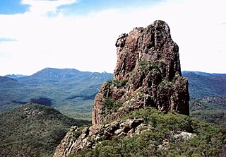
Belar, New South Wales is a bounded rural locality of the Warrumbungle Shire and a civil parish of Gowen County, New South Wales. “Mobla” station near Binnaway is located at the south-east corner of Belar parish near the junction of Greenbah Creek with the Castlereagh River.

Terrabile, New South Wales

Callangoan, New South Wales is a bounded rural locality of Gilgandra Shire, and a civil parish of Gowen County, a county of New South Wales.

Urabrible, New South Wales New South Wales, Australia

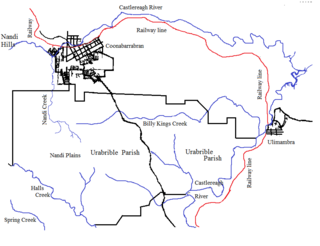
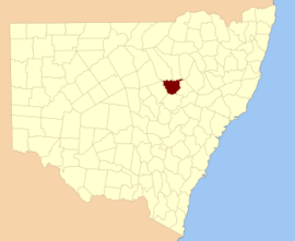
Urabrible, New South Wales is a rural locality of Warrumbungle Shire in Northern New South Wales and a civil parish of Gowen County, New South Wales.

References

  1. "Gowen". Geographical Names Register (GNR) of NSW. Geographical Names Board of New South Wales . Retrieved 30 July 2013. OOjs UI icon edit-ltr-progressive.svg