Leichhardt County

Last updated

Map all coordinates using: OpenStreetMap  
Download coordinates as: KML  ·  GPX
Leichhardt
New South Wales
Leichhardt NSW.png
Location in New South Wales
Lands administrative divisions around Leichhardt:
Narran Finch Baradine
Clyde Leichhardt Baradine
Gregory Ewenmar Gowen

Leichhardt County is one of the 141 Cadastral divisions of New South Wales. It is located south of the Namoi River and includes land on both sides of the Castlereagh River, including Coonamble.

Namoi River

The Namoi River, a major perennial river that is part of the Barwon catchment of the Murray–Darling basin, is located in the Northern Tablelands and North West Slopes districts of New South Wales, Australia.

Castlereagh River river in New South Wales

The Castlereagh River is located in the central–western district of New South Wales, Australia. It is part of the Macquarie-Castlereagh catchment within the Murray–Darling basin and is an unregulated river, meaning no dams or storage have been built on it to control flows. On a map of NSW, the Castlereagh has a distinctive appearance among the north-western rivers for its fish-hook-like shape: from upstream in the north at its confluence with the Macquarie River it extends southwards to a hook-shape, flattened-out at the base, which curves to the right through to the tip of the hook in the Warrumbungle Mountains at the river's source.

Leichhardt County was named in honour of the Prussian naturalist and explorer Friedrich Wilhelm Ludwig Leichhardt (1813-1848). [1]

Ludwig Leichhardt German explorer of Australia

Friedrich Wilhelm Ludwig Leichhardt, known as Ludwig Leichhardt, was a German explorer and naturalist, most famous for his exploration of northern and central Australia.

Parishes within the county

A full list of parishes found within this county; their current LGA and mapping coordinates to the approximate centre of each location is as follows:

Local government in Australia

Local government in Australia is the third tier of government in Australia administered by the states and territories, which in turn are beneath the federal tier. Local government is not mentioned in the Constitution of Australia and two referenda in the 1970s and 1980s to alter the Constitution relating to local government were unsuccessful. Every state government recognises local government in their respective constitutions. Unlike Canada or the United States, there is only one level of local government in each state, with no distinction such as cities and counties.

ParishLGACoordinates
Aberfoyle Walgett Shire 30°05′54″S147°50′04″E / 30.09833°S 147.83444°E / -30.09833; 147.83444 (Aberfoyle)
Amos Walgett Shire 30°13′54″S147°54′04″E / 30.23167°S 147.90111°E / -30.23167; 147.90111 (Amos)
Baronne Coonamble Shire 31°11′54″S148°40′04″E / 31.19833°S 148.66778°E / -31.19833; 148.66778 (Baronne)
Bimble Coonamble Shire 30°51′54″S148°24′04″E / 30.86500°S 148.40111°E / -30.86500; 148.40111 (Bimble)
Bogewang Walgett Shire 30°13′54″S147°44′04″E / 30.23167°S 147.73444°E / -30.23167; 147.73444 (Bogewang)
Borgara Walgett Shire 30°11′54″S147°46′04″E / 30.19833°S 147.76778°E / -30.19833; 147.76778 (Borgara)
Brewan Walgett Shire 30°07′54″S147°36′04″E / 30.13167°S 147.60111°E / -30.13167; 147.60111 (Brewan)
Buchanan Coonamble Shire 31°05′54″S148°48′04″E / 31.09833°S 148.80111°E / -31.09833; 148.80111 (Buchanan)
Budgeon Coonamble Shire 31°07′54″S148°18′04″E / 31.13167°S 148.30111°E / -31.13167; 148.30111 (Budgeon)
Bulgah Coonamble Shire 30°27′54″S148°20′04″E / 30.46500°S 148.33444°E / -30.46500; 148.33444 (Bulgah)
Bulgogar Coonamble Shire 30°41′54″S148°29′04″E / 30.69833°S 148.48444°E / -30.69833; 148.48444 (Bulgogar)
Bullarora Coonamble Shire 30°37′54″S148°20′04″E / 30.63167°S 148.33444°E / -30.63167; 148.33444 (Bullarora)
Calga Coonamble Shire 31°00′54″S148°42′04″E / 31.01500°S 148.70111°E / -31.01500; 148.70111 (Calga)
Cambara Coonamble Shire 31°11′54″S148°18′04″E / 31.19833°S 148.30111°E / -31.19833; 148.30111 (Cambara)
Campbell Coonamble Shire 30°47′54″S148°28′04″E / 30.79833°S 148.46778°E / -30.79833; 148.46778 (Campbell)
Carrabear Coonamble Shire 30°57′54″S148°02′04″E / 30.96500°S 148.03444°E / -30.96500; 148.03444 (Carrabear)
Carwell Coonamble Shire 31°12′54″S148°45′04″E / 31.21500°S 148.75111°E / -31.21500; 148.75111 (Carwell)
Castlereagh Walgett Shire 30°17′54″S147°54′04″E / 30.29833°S 147.90111°E / -30.29833; 147.90111 (Castlereagh)
Collinouie Coonamble Shire 30°27′54″S148°24′04″E / 30.46500°S 148.40111°E / -30.46500; 148.40111 (Collinouie)
Colmia Walgett Shire 30°15′54″S148°04′04″E / 30.26500°S 148.06778°E / -30.26500; 148.06778 (Colmia)
Colomy Walgett Shire 30°19′54″S147°58′04″E / 30.33167°S 147.96778°E / -30.33167; 147.96778 (Colomy)
Conimbia Coonamble Shire 30°41′54″S148°04′04″E / 30.69833°S 148.06778°E / -30.69833; 148.06778 (Conimbia)
Cooeyah Warrah Coonamble Shire 30°27′54″S148°14′04″E / 30.46500°S 148.23444°E / -30.46500; 148.23444 (Cooeyah Warrah)
Coonamble Coonamble Shire 30°57′54″S148°20′04″E / 30.96500°S 148.33444°E / -30.96500; 148.33444 (Coonamble)
Coonamoona Coonamble Shire 30°55′08″S148°37′08″E / 30.91889°S 148.61889°E / -30.91889; 148.61889 (Coonamoona)
Dahomey Walgett Shire 30°27′54″S148°08′04″E / 30.46500°S 148.13444°E / -30.46500; 148.13444 (Dahomey)
Devon Walgett Shire 30°21′54″S147°54′04″E / 30.36500°S 147.90111°E / -30.36500; 147.90111 (Devon)
Dinoa Coonamble Shire 30°51′54″S148°14′04″E / 30.86500°S 148.23444°E / -30.86500; 148.23444 (Dinoa)
Edgeroi Coonamble Shire 30°57′54″S148°08′04″E / 30.96500°S 148.13444°E / -30.96500; 148.13444 (Edgeroi)
Ellis Coonamble Shire 31°07′54″S148°30′04″E / 31.13167°S 148.50111°E / -31.13167; 148.50111 (Ellis)
Elongery Coonamble Shire 31°12′54″S148°55′04″E / 31.21500°S 148.91778°E / -31.21500; 148.91778 (Elongery)
Eulah Coonamble Shire 31°03′54″S148°14′04″E / 31.06500°S 148.23444°E / -31.06500; 148.23444 (Eulah)
Euroka Walgett Shire 30°05′54″S148°06′04″E / 30.09833°S 148.10111°E / -30.09833; 148.10111 (Euroka)
Geelnoy Coonamble Shire 30°45′54″S148°46′04″E / 30.76500°S 148.76778°E / -30.76500; 148.76778 (Geelnoy)
Gelambula Coonamble Shire 30°51′54″S148°28′04″E / 30.86500°S 148.46778°E / -30.86500; 148.46778 (Gelambula)
Gidgerygah Walgett Shire 30°21′54″S147°48′04″E / 30.36500°S 147.80111°E / -30.36500; 147.80111 (Gidgerygah)
Gidginbilla Walgett Shire 30°23′54″S148°14′04″E / 30.39833°S 148.23444°E / -30.39833; 148.23444 (Gidginbilla)
Gilgooma Coonamble Shire 30°46′39″S148°32′16″E / 30.77750°S 148.53778°E / -30.77750; 148.53778 (Gilgooma)
Gilguldry Coonamble Shire 31°11′54″S148°22′04″E / 31.19833°S 148.36778°E / -31.19833; 148.36778 (Gilguldry)
Gilwarny Walgett Shire 30°25′54″S147°50′04″E / 30.43167°S 147.83444°E / -30.43167; 147.83444 (Gilwarny)
Goorianawa Coonamble Shire 31°06′55″S148°52′40″E / 31.11528°S 148.87778°E / -31.11528; 148.87778 (Goorianawa)
Gungalman North Coonamble Shire 30°25′54″S147°58′04″E / 30.43167°S 147.96778°E / -30.43167; 147.96778 (Gungalman North)
Gungalman Coonamble Shire 30°31′54″S148°02′04″E / 30.53167°S 148.03444°E / -30.53167; 148.03444 (Gungalman)
Gunna Walgett Shire 30°11′54″S148°10′04″E / 30.19833°S 148.16778°E / -30.19833; 148.16778 (Gunna)
Keadool Coonamble Shire 30°25′54″S148°22′04″E / 30.43167°S 148.36778°E / -30.43167; 148.36778 (Keadool)
Kidgar Walgett Shire 30°15′54″S147°50′04″E / 30.26500°S 147.83444°E / -30.26500; 147.83444 (Kidgar)
Magometon Coonamble Shire 31°03′54″S148°35′04″E / 31.06500°S 148.58444°E / -31.06500; 148.58444 (Magometon)
Matouree Coonamble Shire 30°25′54″S148°18′04″E / 30.43167°S 148.30111°E / -30.43167; 148.30111 (Matouree)
Mogil Coonamble Shire 30°51′54″S148°04′04″E / 30.86500°S 148.06778°E / -30.86500; 148.06778 (Mogil)
Moolambong Coonamble Shire 31°07′54″S148°24′04″E / 31.13167°S 148.40111°E / -31.13167; 148.40111 (Moolambong)
Moora Walgett Shire 30°17′54″S148°14′04″E / 30.29833°S 148.23444°E / -30.29833; 148.23444 (Moora)
Moorambilla Coonamble Shire 30°57′54″S148°24′04″E / 30.96500°S 148.40111°E / -30.96500; 148.40111 (Moorambilla)
Mourabie Walgett Shire 30°07′54″S147°44′04″E / 30.13167°S 147.73444°E / -30.13167; 147.73444 (Mourabie)
Mowlma Coonamble Shire 30°41′54″S148°10′04″E / 30.69833°S 148.16778°E / -30.69833; 148.16778 (Mowlma)
Mundare Coonamble Shire 30°57′54″S148°30′04″E / 30.96500°S 148.50111°E / -30.96500; 148.50111 (Mundare)
Mundare Coonamble Shire 30°59′54″S148°32′04″E / 30.99833°S 148.53444°E / -30.99833; 148.53444 (Mundare)
Mungery Coonamble Shire 31°05′54″S148°40′04″E / 31.09833°S 148.66778°E / -31.09833; 148.66778 (Mungery)
Munna Munna Coonamble Shire 30°31′54″S147°56′04″E / 30.53167°S 147.93444°E / -30.53167; 147.93444 (Munna Munna)
Murraiman Coonamble Shire 30°58′26″S148°42′27″E / 30.97389°S 148.70750°E / -30.97389; 148.70750 (Murraiman)
Narratigah Coonamble Shire 31°00′54″S148°48′04″E / 31.01500°S 148.80111°E / -31.01500; 148.80111 (Narratigah)
Nebea Coonamble Shire 30°51′22″S148°33′54″E / 30.85611°S 148.56500°E / -30.85611; 148.56500 (Nebea)
Nedgera Coonamble Shire 30°27′54″S147°56′04″E / 30.46500°S 147.93444°E / -30.46500; 147.93444 (Nedgera)
Neinby Coonamble Shire 31°03′54″S148°06′04″E / 31.06500°S 148.10111°E / -31.06500; 148.10111 (Neinby)
Nelgowrie Coonamble Shire 30°53′54″S148°10′04″E / 30.89833°S 148.16778°E / -30.89833; 148.16778 (Nelgowrie)
Nimbia Coonamble Shire 30°41′54″S147°56′04″E / 30.69833°S 147.93444°E / -30.69833; 147.93444 (Nimbia)
Ningear Coonamble Shire 30°47′54″S148°08′04″E / 30.79833°S 148.13444°E / -30.79833; 148.13444 (Ningear)
Noonbar Coonamble Shire 30°59′54″S148°35′04″E / 30.99833°S 148.58444°E / -30.99833; 148.58444 (Noonbar)
Nugal Walgett Shire 30°21′54″S148°05′04″E / 30.36500°S 148.08444°E / -30.36500; 148.08444 (Nugal)
Oural Coonamble Shire 30°35′54″S148°08′04″E / 30.59833°S 148.13444°E / -30.59833; 148.13444 (Oural)
Parmiduan Coonamble Shire 31°08′54″S148°51′04″E / 31.14833°S 148.85111°E / -31.14833; 148.85111 (Parmiduan)
Pier Pier Coonamble Shire 30°35′54″S147°54′04″E / 30.59833°S 147.90111°E / -30.59833; 147.90111 (Pier Pier)
Quanda Quanda Coonamble Shire 31°06′54″S148°46′04″E / 31.11500°S 148.76778°E / -31.11500; 148.76778 (Quanda Quanda)
Quonmoona Coonamble Shire 31°01′54″S148°18′04″E / 31.03167°S 148.30111°E / -31.03167; 148.30111 (Quonmoona)
Sussex Walgett Shire 30°09′54″S147°58′04″E / 30.16500°S 147.96778°E / -30.16500; 147.96778 (Sussex)
Tahrone Coonamble Shire 30°43′54″S148°22′04″E / 30.73167°S 148.36778°E / -30.73167; 148.36778 (Tahrone)
Tallegar Coonamble Shire 31°05′54″S148°14′04″E / 31.09833°S 148.23444°E / -31.09833; 148.23444 (Tallegar)
Terembone Coonamble Shire 30°37′54″S148°41′04″E / 30.63167°S 148.68444°E / -30.63167; 148.68444 (Terembone)
Teridgerie Coonamble Shire 30°55′54″S149°48′04″E / 30.93167°S 149.80111°E / -30.93167; 149.80111 (Teridgerie)
Thara Coonamble Shire 30°37′54″S148°26′04″E / 30.63167°S 148.43444°E / -30.63167; 148.43444 (Thara)
Toloora Walgett Shire 30°09′54″S148°04′04″E / 30.16500°S 148.06778°E / -30.16500; 148.06778 (Toloora)
Tooloon Coonamble Shire 30°57′54″S148°14′04″E / 30.96500°S 148.23444°E / -30.96500; 148.23444 (Tooloon)
Toora Coonamble Shire 30°33′54″S148°02′04″E / 30.56500°S 148.03444°E / -30.56500; 148.03444 (Toora)
Trielmon Walgett Shire 30°15′54″S147°58′04″E / 30.26500°S 147.96778°E / -30.26500; 147.96778 (Trielmon)
Ularbie Walgett Shire 30°03′54″S148°00′04″E / 30.06500°S 148.00111°E / -30.06500; 148.00111 (Ularbie)
Ulundry Coonamble Shire 31°12′54″S148°30′04″E / 31.21500°S 148.50111°E / -31.21500; 148.50111 (Ulundry)
Urawilkie Coonamble Shire 30°50′28″S148°42′42″E / 30.84111°S 148.71167°E / -30.84111; 148.71167 (Urawilkie)
Waddiwong Walgett Shire 30°07′54″S147°54′04″E / 30.13167°S 147.90111°E / -30.13167; 147.90111 (Waddiwong)
Walcha Council Coonamble Shire 30°36′54″S148°35′04″E / 30.61500°S 148.58444°E / -30.61500; 148.58444 (Walcha Council)
Walla Walla Coonamble Shire 31°08′54″S148°34′04″E / 31.14833°S 148.56778°E / -31.14833; 148.56778 (Walla Walla)
Wambelong Coonamble Shire 31°12′54″S148°50′04″E / 31.21500°S 148.83444°E / -31.21500; 148.83444 (Wambelong)
Warraba East Coonamble Shire 30°42′54″S148°39′04″E / 30.71500°S 148.65111°E / -30.71500; 148.65111 (Warraba East)
Warrabah Coonamble Shire 30°55′54″S148°02′04″E / 30.93167°S 148.03444°E / -30.93167; 148.03444 (Warrabah)
Warragan Walgett Shire 30°17′54″S148°08′04″E / 30.29833°S 148.13444°E / -30.29833; 148.13444 (Warragan)
Warren Downs Walgett Shire 30°17′54″S147°44′04″E / 30.29833°S 147.73444°E / -30.29833; 147.73444 (Warren Downs)
Warrena Coonamble Shire 30°57′54″S148°28′04″E / 30.96500°S 148.46778°E / -30.96500; 148.46778 (Warrena)
Weetaliba Coonamble Shire 30°42′54″S148°34′04″E / 30.71500°S 148.56778°E / -30.71500; 148.56778 (Weetaliba)
Willaga Coonamble Shire 30°47′15″S148°38′33″E / 30.78750°S 148.64250°E / -30.78750; 148.64250 (Willaga)
Wingadee Coonamble Shire 30°09′54″S148°12′04″E / 30.16500°S 148.20111°E / -30.16500; 148.20111 (Wingadee)
Wingadee Coonamble Shire 30°27′54″S148°12′04″E / 30.46500°S 148.20111°E / -30.46500; 148.20111 (Wingadee)
Winnaba Coonamble Shire 30°29′54″S148°34′04″E / 30.49833°S 148.56778°E / -30.49833; 148.56778 (Winnaba)
Woolingar Coonamble Shire 30°39′54″S148°14′04″E / 30.66500°S 148.23444°E / -30.66500; 148.23444 (Woolingar)
Worinjerong Coonamble Shire 31°12′54″S148°34′04″E / 31.21500°S 148.56778°E / -31.21500; 148.56778 (Worinjerong)
Yarragoora Coonamble Shire 30°45′54″S148°14′04″E / 30.76500°S 148.23444°E / -30.76500; 148.23444 (Yarragoora)
Yarrayin Coonamble Shire 30°47′54″S148°02′04″E / 30.79833°S 148.03444°E / -30.79833; 148.03444 (Yarrayin)
Yoee Coonamble Shire 30°51′54″S148°20′04″E / 30.86500°S 148.33444°E / -30.86500; 148.33444 (Yoee)
Youendah Walgett Shire 30°03′54″S147°56′04″E / 30.06500°S 147.93444°E / -30.06500; 147.93444 (Youendah)
Yuma Coonamble Shire 30°47′54″S148°22′04″E / 30.79833°S 148.36778°E / -30.79833; 148.36778 (Yuma)

Related Research Articles

Inner West Region in New South Wales, Australia

The Inner West Sydney is an area directly west of the Sydney central business district, New South Wales, Australia. The suburbs of the Inner West are predominantly located along the southern shore of Port Jackson, stretching south to the shores of the Cooks River. The western boundary is Homebush Bay Drive & Centenary Drive.

Leichhardt, New South Wales Suburb of Sydney, New South Wales, Australia

Leichhardt is a suburb in the Inner West of Sydney, in the state of New South Wales, Australia. Leichhardt is located 5 kilometres west of the Sydney central business district (CBD) and is the administrative centre for the local government area (LGA) of the Inner West Council. The suburb is bordered by Haberfield to the west, Annandale to the east, Lilyfield to the north and Petersham, Lewisham and Stanmore to the south.

County of Cumberland, New South Wales Cadastral in New South Wales, Australia

Cumberland County is a county in the State of New South Wales, Australia. Most of the Sydney metropolitan area is located within the County of Cumberland.

Lilyfield, New South Wales Suburb of Sydney, New South Wales, Australia

Lilyfield is a suburb in the Inner West of Sydney, in the state of New South Wales, Australia. Lilyfield is located 6 kilometres west of the Sydney central business district, in the local government area of the Inner West Council.

Barwon Highway highway in Queensland

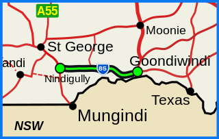
The Barwon Highway is one of the shorter state highways of Queensland, Australia. It starts at the Carnarvon Highway in Nindigully, 44 kilometres south of St George, and travels east for about 155 kilometres until it reaches Goondiwindi, where it terminates at the Leichhardt Highway.

Sydney Secondary College

Sydney Secondary College is a multi-campus urban government-funded, co-educational, dual modality, partially academically selective and comprehensive secondary day school, located in the Inner-West region of Sydney, New South Wales, Australia.

Corowa Town in New South Wales, Australia

Corowa is a town in the state of New South Wales in Australia. It is on the bank of the Murray River, the border between New South Wales and Victoria, opposite the Victorian town of Wahgunyah. It is the largest town in the Federation Council and was the administrative centre of the former Corowa Shire. The name could have derived from an Aboriginal word referring to the curra pine which yielded gum used by Aborigines to fasten the heads of spears to the shafts. Another translation is rocky river.

Municipality of Leichhardt Local government area in New South Wales, Australia

The Municipality of Leichhardt was a local government area in the inner-west region of Sydney, New South Wales, Australia. It is about 10 kilometres (6.2 mi) west of the Sydney central business district. On 12 May 2016, Leichhardt merged with Marrickville Council and the Municipality of Ashfield to form the Inner West Council.

Leichhardt Oval

Leichhardt Oval is a football and soccer stadium in Leichhardt, New South Wales, Australia. It is currently one of 3 home grounds for the Wests Tigers National Rugby League team, along with Campbelltown Stadium and Western Sydney Stadium. Prior to its merger with the Western Suburbs Magpies, it was the longtime home of the Balmain Tigers, who used the ground from 1934–1994 and 1997–1999.

Hawthorne Canal

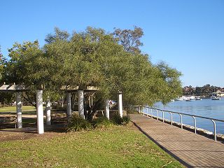
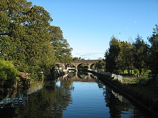
The Hawthorne Canal, a southern tributary of the Parramatta River, is a heritage–listed artificial waterway located in the western reaches of Sydney Harbour, in the inner–western Sydney suburbs of Lewisham, Summer Hill, Haberfield, and Leichhardt in New South Wales, Australia.

Dawson River (Queensland) river in Queensland, Australia

The Dawson River is a river located in Central Queensland, Australia.

The following lists events that happened during 1848 in Australia.

Leichhardt was an electoral district of the Legislative Assembly in the Australian state of New South Wales, created in 1894, with the abolition of multi-member electorates and partly replacing Balmain, and named after and including the Sydney suburb of Leichhardt. With the introduction of proportional representation, it was absorbed into the multi-member electorate of Western Suburbs. It was recreated in 1927, but was abolished in 1962.

Parish of Petersham Cadastral in New South Wales, Australia

Petersham Parish is one of the 57 parishes of Cumberland County, New South Wales, a cadastral unit for use on land titles. It is located to the south of Iron Cove, Rozelle Bay and the Parramatta River, and to the north of Cooks River. It includes the suburbs of Balmain, Leichhardt, Petersham, Newtown, Marrickville, Tempe, Glebe and St Peters.

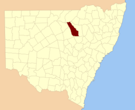
Moreton, Wide Bay, Burnett and Maranoa, and from 1857 Moreton, Wide Bay, Burnett, Maranoa, Leichhardt and Port Curtis, was an electoral district of the Legislative Assembly in the Australian state of New South Wales created in 1856 and consisted of the pastoral districts around the early settlements of Moreton Bay; Wide Bay, near Maryborough; the Burnett River, near Bundaberg; and the Maranoa region of South-western Queensland. In September 1856 the pastoral districts around the Leichhardt River in the Gulf of Carpentaria region and Port Curtis (Gladstone) were added to the electorate. The district was abolished for the 1859 election and replaced by the separate districts of East Moreton, West Moreton, Burnett and Leichhardt, while Maranoa became part of Darling Downs. All of these districts became part of Queensland when it was established as a separate colony in late 1859.

Leichhardt was an electoral district of the Legislative Assembly in the Australian state of New South Wales

Johnstons Creek (New South Wales) river in New South Wales, Australia

Johnstons Creek, formerly Johnston's Creek, is an urban gully, located in Sydney, Australia and situated in the Leichhardt local government area. The creek flows from Petersham, past Annandale, Camperdown, Forest Lodge and Harold Park, before spilling into Rozelle Bay, within Sydney Harbour.

William Henry Suttor (Senior) was an Australian pastoralist and politician.

Sydney Secondary College Leichhardt Campus

The Leichhardt Campus of the Sydney Secondary College is a government-funded, co-educational, dual modality, partially academically selective and comprehensive junior secondary day school, located in the inner-western Sydney suburb of Leichhardt, New South Wales, Australia. Together with the senior school at the Blackwattle Bay Campus and the other junior school at Balmain Campus, the school is a part of the Sydney Secondary College.

References

  1. "Leichhardt". Geographical Names Register (GNR) of NSW. Geographical Names Board of New South Wales . Retrieved 4 August 2013. OOjs UI icon edit-ltr-progressive.svg