Ewenmar County

Last updated

Ewenmar
New South Wales
Ewenmar NSW.PNG
Location in New South Wales
Lands administrative divisions around Ewenmar:
Gregory Leichhardt Gowen
Oxley Ewenmar Gowen
Narromine Narromine Lincoln

Ewenmar County is one of the 141 cadastral divisions of New South Wales. It is located between the Macquarie River on the west and the Castlereagh River on the east, between Warren and Gilgandra. The name derives from a local Aboriginal word. [1]

Parishes

A full list of parishes in this county, their current LGA and approximately central mapping coordinates follow:

ParishLGACoordinates
Allamurgoola Gilgandra Shire 31°25′54″S148°30′04″E / 31.43167°S 148.50111°E / -31.43167; 148.50111 (Allamurgoola)
Armatree Coonamble Shire 31°23′54″S148°24′04″E / 31.39833°S 148.40111°E / -31.39833; 148.40111 (Armatree)
Balladoran Gilgandra Shire 31°47′54″S148°35′04″E / 31.79833°S 148.58444°E / -31.79833; 148.58444 (Balladoran)
Beemunnel Warren Shire 31°41′54″S148°02′04″E / 31.69833°S 148.03444°E / -31.69833; 148.03444 (Beemunnel)
Berida Gilgandra Shire 31°34′54″S148°28′04″E / 31.58167°S 148.46778°E / -31.58167; 148.46778 (Berida)
Bobarah Gilgandra Shire 31°39′54″S148°37′04″E / 31.66500°S 148.61778°E / -31.66500; 148.61778 (Bobarah)
Boebung Gilgandra Shire 31°27′54″S148°24′04″E / 31.46500°S 148.40111°E / -31.46500; 148.40111 (Boebung)
Bourbah Warren Shire 31°23′54″S148°16′04″E / 31.39833°S 148.26778°E / -31.39833; 148.26778 (Bourbah)
Breelong Gilgandra Shire 31°47′21″S148°41′44″E / 31.78917°S 148.69556°E / -31.78917; 148.69556 (Breelong)
Bugabada Narromine Shire 31°53′54″S148°18′04″E / 31.89833°S 148.30111°E / -31.89833; 148.30111 (Bugabada)
Bullagreen Warren Shire 31°23′54″S148°10′04″E / 31.39833°S 148.16778°E / -31.39833; 148.16778 (Bullagreen)
Bundemar Warren Shire 31°49′54″S148°14′04″E / 31.83167°S 148.23444°E / -31.83167; 148.23444 (Bundemar)
Bundijoe Warren Shire 31°47′54″S148°16′04″E / 31.79833°S 148.26778°E / -31.79833; 148.26778 (Bundijoe)
Bundilla Warren Shire 31°27′54″S148°08′04″E / 31.46500°S 148.13444°E / -31.46500; 148.13444 (Bundilla)
Bundobering Gilgandra Shire 31°41′54″S148°26′04″E / 31.69833°S 148.43444°E / -31.69833; 148.43444 (Bundobering)
Bungey Gilgandra Shire 31°43′54″S148°33′04″E / 31.73167°S 148.55111°E / -31.73167; 148.55111 (Bungey)
Buramilong Gilgandra Shire 31°37′54″S148°31′04″E / 31.63167°S 148.51778°E / -31.63167; 148.51778 (Buramilong)
Burroway Narromine Shire 32°01′54″S148°17′04″E / 32.03167°S 148.28444°E / -32.03167; 148.28444 (Burroway)
Carrigan Narromine Shire 31°51′54″S148°10′04″E / 31.86500°S 148.16778°E / -31.86500; 148.16778 (Carrigan)
Cobboco Gilgandra Shire 31°59′54″S148°26′04″E / 31.99833°S 148.43444°E / -31.99833; 148.43444 (Cobboco)
Collemburrawang Warren Shire 31°27′54″S147°50′04″E / 31.46500°S 147.83444°E / -31.46500; 147.83444 (Collemburrawang)
Collie Warren Shire 31°15′54″S148°42′04″E / 31.26500°S 148.70111°E / -31.26500; 148.70111 (Collie)
Connibong Gilgandra Shire 31°27′54″S148°20′04″E / 31.46500°S 148.33444°E / -31.46500; 148.33444 (Connibong)
Coolbaggie Narromine Shire 32°08′54″S148°24′04″E / 32.14833°S 148.40111°E / -32.14833; 148.40111 (Coolbaggie)
Coradgerie Warren Shire 31°35′54″S148°14′04″E / 31.59833°S 148.23444°E / -31.59833; 148.23444 (Coradgerie)
Driel Warren Shire 31°39′54″S147°56′04″E / 31.66500°S 147.93444°E / -31.66500; 147.93444 (Driel)
Drillwarrina Gilgandra Shire 31°52′54″S148°33′04″E / 31.88167°S 148.55111°E / -31.88167; 148.55111 (Drillwarrina)
Eiraban Gilgandra Shire 31°47′54″S148°24′04″E / 31.79833°S 148.40111°E / -31.79833; 148.40111 (Eiraban)
Emogandry Narromine Shire 31°57′54″S148°16′04″E / 31.96500°S 148.26778°E / -31.96500; 148.26778 (Emogandry)
Emu Gilgandra Shire 31°55′54″S148°40′04″E / 31.93167°S 148.66778°E / -31.93167; 148.66778 (Emu)
Eumungerie Gilgandra Shire 31°56′54″S148°32′04″E / 31.94833°S 148.53444°E / -31.94833; 148.53444 (Eumungerie)
Eura Gilgandra Shire 31°49′54″S148°42′04″E / 31.83167°S 148.70111°E / -31.83167; 148.70111 (Eura)
Eurombedah Narromine Shire 32°12′54″S148°19′04″E / 32.21500°S 148.31778°E / -32.21500; 148.31778 (Eurombedah)
Gewah Warren Shire 31°35′54″S148°18′04″E / 31.59833°S 148.30111°E / -31.59833; 148.30111 (Gewah)
Gulargambone Coonamble Shire 31°19′54″S148°16′04″E / 31.33167°S 148.26778°E / -31.33167; 148.26778 (Gulargambone)
Healy Warren Shire 31°25′54″S148°22′04″E / 31.43167°S 148.36778°E / -31.43167; 148.36778 (Healy)
Kickabil Gilgandra Shire 31°53′54″S148°22′04″E / 31.89833°S 148.36778°E / -31.89833; 148.36778 (Kickabil)
Killendoon Warren Shire 31°45′54″S147°56′04″E / 31.76500°S 147.93444°E / -31.76500; 147.93444 (Killendoon)
Merrigal Warren Shire 31°27′54″S148°14′04″E / 31.46500°S 148.23444°E / -31.46500; 148.23444 (Merrigal)
Meryon Warren Shire 31°35′54″S148°08′04″E / 31.59833°S 148.13444°E / -31.59833; 148.13444 (Meryon)
Milda Gilgandra Shire 31°31′54″S148°31′04″E / 31.53167°S 148.51778°E / -31.53167; 148.51778 (Milda)
Milpulling Gilgandra Shire 31°46′54″S148°30′04″E / 31.78167°S 148.50111°E / -31.78167; 148.50111 (Milpulling)
Moonul City of Dubbo 32°00′54″S148°28′04″E / 32.01500°S 148.46778°E / -32.01500; 148.46778 (Moonul)
Narroweema Warren Shire 31°43′54″S148°10′04″E / 31.73167°S 148.16778°E / -31.73167; 148.16778 (Narroweema)
Tacklebang Gilgandra Shire 31°41′54″S148°20′04″E / 31.69833°S 148.33444°E / -31.69833; 148.33444 (Tacklebang)
Tenandra Warren Shire 31°27′54″S147°56′04″E / 31.46500°S 147.93444°E / -31.46500; 147.93444 (Tenandra)
Umangla Warren Shire 31°35′54″S147°48′04″E / 31.59833°S 147.80111°E / -31.59833; 147.80111 (Umangla)
Urobula Warren Shire 31°41′54″S148°10′04″E / 31.69833°S 148.16778°E / -31.69833; 148.16778 (Urobula)
Wambianna Warren Shire 31°51′54″S148°06′04″E / 31.86500°S 148.10111°E / -31.86500; 148.10111 (Wambianna)
Warrie Coonamble Shire 31°17′54″S148°22′04″E / 31.29833°S 148.36778°E / -31.29833; 148.36778 (Warrie)
Wemabung Warren Shire 30°59′54″S148°04′04″E / 30.99833°S 148.06778°E / -30.99833; 148.06778 (Wemabung)
Wirrigai Narromine Shire 32°06′54″S148°17′04″E / 32.11500°S 148.28444°E / -32.11500; 148.28444 (Wirrigai)
Wonbobbie Warren Shire 31°33′54″S147°58′04″E / 31.56500°S 147.96778°E / -31.56500; 147.96778 (Wonbobbie)

Related Research Articles

<span class="mw-page-title-main">Gloucester County, New South Wales</span> Cadastral in New South Wales, Australia

Gloucester County was one of the original Nineteen Counties in New South Wales, and is now one of the 141 cadastral divisions of New South Wales. It includes the area around Port Stephens. It is bounded on the north and west by the Manning River, and on the south-west by the Williams River.

<span class="mw-page-title-main">Northumberland County, New South Wales</span> Cadastral in New South Wales, Australia

Northumberland County was one of the original Nineteen Counties in New South Wales and is now one of the 141 Cadastral divisions of New South Wales. It included the area to the north of Broken Bay, which compasses the Central Coast region and Lake Macquarie as well as Newcastle(Greater Newcastle) in the Hunter region. It was bounded by the part of the Hawkesbury River to the south, the Macdonald River to the south-west, and the Hunter River to the north.

<span class="mw-page-title-main">Camden County, New South Wales</span> Cadastral in New South Wales, Australia

Camden County was one of the original Nineteen Counties in New South Wales and is now one of the 141 Cadastral divisions of New South Wales. It included the coastal area near Wollongong south to the Shoalhaven River, and also inland encompassing Berrima and Picton. Its western boundary was the Wollondilly River. The first settlement in the area was Camden Park, established by John Macarthur in 1806, just across the Nepean River from Cumberland County. It was the first land across the Nepean to be settled. Camden is a present-day suburb of Sydney in the same area, although parts of it are in Cumberland.

<span class="mw-page-title-main">St Vincent County</span> Cadastral in Australian Capital Territory

St Vincent County was one of the original Nineteen Counties in New South Wales and is now one of the 141 Cadastral divisions of New South Wales. It included the south coast area encompassing Batemans Bay, Ulladulla, Jervis Bay and inland to Braidwood. The Shoalhaven River is the boundary to the north and west, and the Deua River the boundary to the south.

<span class="mw-page-title-main">Hunter County</span> Cadastral in New South Wales, Australia

Hunter County was one of the original Nineteen Counties in New South Wales and is now one of the 141 Cadastral divisions of New South Wales. It lies between the Hunter River in the north, and the Colo River in the south, including much of Wollemi National Park. Macdonald River lies to the east.

<span class="mw-page-title-main">Cook County, New South Wales</span> Cadastral in New South Wales, Australia

Cook County was one of the original Nineteen Counties in New South Wales and is now one of the 141 Cadastral divisions of New South Wales. It includes the area to the west of Sydney in the Blue Mountains, between the Colo River in the north, and the Coxs River in the south and west, encompassing Lithgow, Mount Victoria, Katoomba, Wentworth Falls, Lawson and most of the other towns in the Blue Mountains. The Nepean River is the border to the east. Before 1834, the area was part of the Westmoreland, Northumberland and Roxburgh counties.

<span class="mw-page-title-main">Westmoreland County, New South Wales</span> Cadastral in New South Wales, Australia

Westmoreland County was one of the original Nineteen Counties in New South Wales and is now one of the 141 Cadastral divisions of New South Wales. It is to the west of Sydney in the Blue Mountains. Coxs River is the border to the north, and the Wollondilly River to the east. Campbells River is the border in the north-east, where the county extends to near Bathurst, with the Fish River part of the border. It includes the town of Oberon, and the Kanangra-Boyd National Park.

<span class="mw-page-title-main">Georgiana County</span> Cadastral in New South Wales, Australia

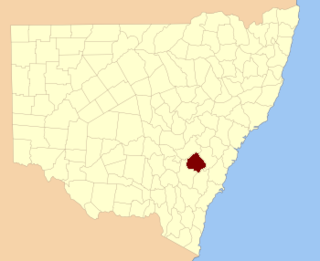
Georgiana County was one of the original Nineteen Counties in New South Wales and is now one of the 141 Cadastral divisions of New South Wales. It lies in the area about halfway between Bathurst and Goulburn. The Lachlan River is the western boundary, with the Crookwell River the southern boundary. It includes Bigga, and the area surrounding the Abercrombie River. It was part of the Electoral district of King and Georgiana from 1856 to 1859.

<span class="mw-page-title-main">King County, New South Wales</span> Cadastral in New South Wales, Australia

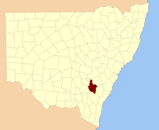
King County was one of the original Nineteen Counties in New South Wales and is now one of the 141 cadastral divisions of New South Wales. It is in the area to the east of Yass. The northern part of it lies between the Lachlan River and the Boorowa River, including the locations of Frogmore, Taylors Flat, Gunnary, Rugby and Rye Park. The Crookwell River is also part of the northern boundary. The Yass River is the southern boundary.

<span class="mw-page-title-main">Roxburgh County</span> Cadastral in New South Wales, Australia

Roxburgh County was one of the original Nineteen Counties in New South Wales and is now one of the 141 Cadastral divisions of New South Wales. It includes the area to the north east of Bathurst, lying to the north and east of the Fish River to the junction of the Turon River. It includes Sofala. The Gudgegong River is the border to the north.

<span class="mw-page-title-main">Bathurst County</span> Cadastral in New South Wales, Australia

Bathurst County was one of the original Nineteen Counties in New South Wales and is now one of the 141 Cadastral divisions of New South Wales. It includes the area to the south-west of Bathurst to Cowra and Orange. The Lachlan River is the boundary to the south-west, the Belubula River forms part of the northern boundary, with the Fish River on the northeastern boundary. Blayney is located roughly in the middle.

<span class="mw-page-title-main">Brisbane County</span> Cadastral in New South Wales, Australia

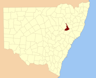
Brisbane County was one of the original Nineteen Counties in New South Wales and is now one of the 141 Cadastral divisions of New South Wales. It includes Scone, Merriwa and Murrurundi. The Goulburn River is the boundary to the south and the Hunter River the boundary to the south-east. The Liverpool Range area is the boundary to the north, and the Krui River the boundary to the west.

<span class="mw-page-title-main">Bligh County</span> Cadastral in New South Wales, Australia

Bligh County was one of the original Nineteen Counties in New South Wales and is now one of the 141 Cadastral divisions of New South Wales. The Cudgegong River and the Goulburn River are its southern boundaries; the Krui River is the eastern boundary, and the Burragundy River the northern boundary. It includes the villages of Cassilis and Dunedoo.

<span class="mw-page-title-main">Phillip County</span> Cadastral in New South Wales, Australia

Phillip County was one of the original Nineteen Counties in New South Wales and is now one of the 141 Cadastral divisions of New South Wales. It includes the area to the east of Mudgee and Gulgong. The Cudgegong River is the border to the south-west, and the Goulburn River the border to the north.

<span class="mw-page-title-main">Waradgery County</span> Cadastral in New South Wales, Australia

Waradgery County is one of the 141 Cadastral divisions of New South Wales. It contains the town of Hay. It includes the area between the Lachlan River and the Murrumbidgee River where they meet. The Lachlan River is the northern boundary of the county, and the Murrumbidgee for a small section is the southern boundary, but the county also includes some of the land to the south of the Murrumbidgee near Hay.

<span class="mw-page-title-main">Buckland County</span> Cadastral in New South Wales, Australia

Buckland County is one of the 141 Cadastral divisions of New South Wales. It is situated between a small part of the Namoi River in the north to the Liverpool Range in the south. The Mooki River is the boundary to the west. It includes Quirindi.

<span class="mw-page-title-main">Clyde County</span> Cadastral in New South Wales, Australia

Clyde County is one of the 141 Cadastral divisions of the Australian state of New South Wales. It is located between the Bogan River and Barwon River in the area between them where they join. This is the area to the south of Brewarrina, as far east as the Carinda area. A very small part of the Macquarie River and Castlereagh River is also part of the boundary in the north-east.

<span class="mw-page-title-main">Denham County</span> Cadastral in New South Wales, Australia

Denham County, is one of the 141 Cadastral divisions of New South Wales. It lies between the Barwon River and the Namoi River, where the two rivers meet. It includes the localities of Koothney, Cryon and Bugilbone.

<span class="mw-page-title-main">Narromine County</span> Cadastral in New South Wales, Australia

Narromine County is one of the 141 Cadastral divisions of New South Wales. It is located between the Bogan River on the west and the Macquarie River on the east, in the area around Narromine.

<span class="mw-page-title-main">Oxley County</span> Cadastral in New South Wales, Australia

Oxley County, New South Wales is one of the 141 Cadastral divisions of New South Wales. It is located between the Bogan River on the west, and the Macquarie River on the east. This is the area approximately between Warren and Nyngan.

References

  1. "Ewenmar County". Geographical Names Register (GNR) of NSW. Geographical Names Board of New South Wales. OOjs UI icon edit-ltr-progressive.svg