
Cumberland County is a county in the State of New South Wales, Australia. Most of the Sydney metropolitan area is located within the County of Cumberland.

The Yass River, a perennial river that is part of the Murrumbidgee catchment within the Murray–Darling basin, is located in the Southern Tablelands and South Western Slopes districts of New South Wales, Australia.
The Billabong Creek, a perennial river of the Murrumbidgee catchment within the Murray-Darling basin, is located in the South West Slopes region of New South Wales, Australia.

Darbalara is a rural community on the east bank of the junction of the Murrumbidgee River and Tumut River in the Riverina. It is situated by road, about 25 kilometres north east of Gundagai and 25 kilometres south of Coolac.
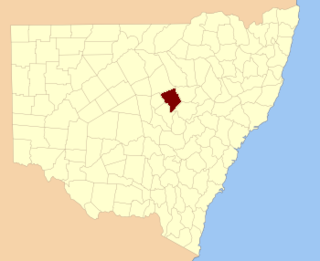
Ewenmar County is one of the 141 Cadastral divisions of New South Wales. It is located between the Macquarie River on the west, and the Castlereagh River on the east. This is the area between Warren and Gilgandra.

Mount Piddington (Aboriginal: Wirindi, a mountain in the Explorer Range of the Blue Mountains region, is located south of the village of Mount Victoria in New South Wales, Australia.

Cobrabald River, a mostly perennial river that is part of the Namoi catchment within the Murray–Darling basin, is located in the Northern Tablelands district of New South Wales, Australia.
Nubba is a locality and former railway station on the Main South railway line in New South Wales, Australia, located midway between Wallendbeen and Harden. The station was open between 1882 and 1975 and has now been demolished. At the 2006 census, Nubba had a population of 281 people.
Burroway is a bounded rural locality to the north of Narromine township and east of Buddah in New South Wales, Australia. The area at Latitude 32° 05' 00" S and Longitude 148° 16' 00" E is roughly equivalent to the cadastral parishes of Burroway and Emogandry in the county of Ewenmar and is in Narromine Shire.
Bettowynd Creek, a partly perennial stream of the Moruya River catchment, is located in the Southern Tablelands and South Coast regions of New South Wales, Australia.
Timbrebongie is a cadastral parish and former village on the Macquarie River to the north of Narromine township in New South Wales, Australia. and Buddah in the county of Ewenmar and is in Narromine Shire. The area is located 11.75km North of Narromine, 26.61 km South East of Trangie and about 340 km northwest of Sydney, New South Wales.

The Kindra Creek, a watercourse that is part of the Murrumbidgee catchment within the Murray–Darling basin, is located in the Riverina and South West Slopes regions of New South Wales, Australia.
Nanima is a locality in the Yass Valley Council area, New South Wales, Australia. It lies on the both sides of the Murrumbateman Road between Murrumbateman and Gundaroo, about 37 km north of Canberra. At the 2016 census, it had a population of 165.

Blowering, New South wales is a rural locality in the Snowy Mountains of New South wales and a civil Parish of Buccleuch County.
Goobarragandra, New South Wales is a rural locality in the Snowy Mountains west of Canberra, Australia.

Yarrangobilly, New South Wales is a rural locality in the Snowy Mountains, west of Canberra, Australia, and is also a civil Parish of Buccleuch County.
Wambianna is a rural locality of Warren Shire and it is a civil parish of County of Ewenmar Wambianna is on the Macquarie River east of Warren, New South Wales.
Driel is a rural locality of Warren Shire 31°39′54″S 147°56′04″E a few miles north of Warren, New South Wales Driel is also a civil Parish]] of Ewenmar County, a cadastral division of New South Wales.
Wirrigai is a rural locality of Warren Shire 31°39′54″S 147°56′04″E a few miles north of Warren, New South Wales Driel is also a civil Parish of Ewenmar County, a cadastral division of New South Wales.
