Murchison County

Last updated

Map all coordinates using: OpenStreetMap  
Download coordinates as: KML
Murchison
New South Wales
Murchison NSW.PNG
Location in New South Wales
Lands administrative divisions around Murchison:
Courallie Burnett Arrawatta
Jamison Murchison Hardinge
Nandewar Darling Hardinge

Murchison County is one of the 141 cadastral divisions of New South Wales, Australia.

Murchison County is named in honour of Sir Roderick Impey Murchison (1792–1871) First Baronet and geologist. [1]

Parishes

Murchison_County_(NSW)_Map_1886 Murchison County (NSW) Map 1886.png
Murchison_County_(NSW)_Map_1886

A full list of parishes found within this county; their current LGA and mapping coordinates to the approximate centre of each location is as follows:

ParishLGACoordinates
Anderson Gwydir Shire 30°07′54″S150°33′04″E / 30.13167°S 150.55111°E / -30.13167; 150.55111 (Anderson Parish)
AustenGwydir Shire 29°59′54″S150°21′04″E / 29.99833°S 150.35111°E / -29.99833; 150.35111 (Austen Parish)
Bangheet Gwydir Shire 29°48′54″S150°30′04″E / 29.81500°S 150.50111°E / -29.81500; 150.50111 (Bangheet Parish)
Bingara Gwydir Shire 29°51′54″S150°32′04″E / 29.86500°S 150.53444°E / -29.86500; 150.53444 (Bingara Parish)
Boomi Moree Plains Shire 30°12′54″S150°18′04″E / 30.21500°S 150.30111°E / -30.21500; 150.30111 (Boomi Parish)
CapelGwydir Shire 30°08′54″S150°40′04″E / 30.14833°S 150.66778°E / -30.14833; 150.66778 (Capel Parish)
Caroda Moree Plains Shire 29°59′54″S150°15′04″E / 29.99833°S 150.25111°E / -29.99833; 150.25111 (Caroda Parish)
Cobbadah Gwydir Shire 30°14′54″S150°34′04″E / 30.24833°S 150.56778°E / -30.24833; 150.56778 (Cobbadah Parish)
CrawleyGwydir Shire 30°14′54″S150°28′04″E / 30.24833°S 150.46778°E / -30.24833; 150.46778 (Crawley Parish)
CurrangandiGwydir Shire 30°09′54″S150°20′04″E / 30.16500°S 150.33444°E / -30.16500; 150.33444 (Currangandi Parish)
DelingeraGwydir Shire 29°43′54″S150°39′04″E / 29.73167°S 150.65111°E / -29.73167; 150.65111 (Delingera Parish)
Delungra Inverell Shire 29°36′54″S150°45′04″E / 29.61500°S 150.75111°E / -29.61500; 150.75111 (Delungra Parish)
Derra DerraGwydir Shire 29°52′24″S150°30′04″E / 29.87333°S 150.50111°E / -29.87333; 150.50111 (Derra Derra Parish)
DingoGwydir Shire 29°52′54″S150°50′04″E / 29.88167°S 150.83444°E / -29.88167; 150.83444 (Dingo Parish)
Dinoga Gwydir Shire 30°00′54″S150°34′04″E / 30.01500°S 150.56778°E / -30.01500; 150.56778 (Dinoga Parish)
DrummondGwydir Shire 30°06′54″S150°45′04″E / 30.11500°S 150.75111°E / -30.11500; 150.75111 (Drummond Parish)
DumboyGwydir Shire 29°39′54″S150°41′04″E / 29.66500°S 150.68444°E / -29.66500; 150.68444 (Dumboy Parish)
DunneeGwydir Shire 30°10′54″S150°30′04″E / 30.18167°S 150.50111°E / -30.18167; 150.50111 (Dunnee Parish)
DurhamGwydir Shire 29°48′54″S150°44′04″E / 29.81500°S 150.73444°E / -29.81500; 150.73444 (Durham Parish)
EulowrieGwydir Shire 30°03′54″S150°07′04″E / 30.06500°S 150.11778°E / -30.06500; 150.11778 (Eulowrie Parish)
EvansGwydir Shire 29°52′24″S150°42′04″E / 29.87333°S 150.70111°E / -29.87333; 150.70111 (Evans Parish)
FurberGwydir Shire 29°56′54″S150°51′04″E / 29.94833°S 150.85111°E / -29.94833; 150.85111 (Furber Parish)
GlassGwydir Shire 29°43′54″S150°20′04″E / 29.73167°S 150.33444°E / -29.73167; 150.33444 (Glass Parish)
GouronGwydir Shire 29°59′54″S150°40′04″E / 29.99833°S 150.66778°E / -29.99833; 150.66778 (Gouron Parish)
Gum Flat Inverell Shire 29°43′54″S150°59′04″E / 29.73167°S 150.98444°E / -29.73167; 150.98444 (Gum Flat Parish)
Gundamulda Gwydir Shire 30°14′54″S150°45′04″E / 30.24833°S 150.75111°E / -30.24833; 150.75111 (Gundamulda Parish)
HallGwydir Shire 30°04′54″S150°34′04″E / 30.08167°S 150.56778°E / -30.08167; 150.56778 (Hall Parish)
Horton Gwydir Shire 30°11′54″S150°24′04″E / 30.19833°S 150.40111°E / -30.19833; 150.40111 (Horton Parish)
Keera Gwydir Shire 30°01′54″S150°45′04″E / 30.03167°S 150.75111°E / -30.03167; 150.75111 (Keera Parish)
KingGwydir Shire 30°04′54″S150°28′04″E / 30.08167°S 150.46778°E / -30.08167; 150.46778 (King Parish)
Lindesay Gwydir Shire 30°18′54″S150°21′04″E / 30.31500°S 150.35111°E / -30.31500; 150.35111 (Lindesay Parish)
Little Plain Inverell Shire 29°48′54″S150°54′04″E / 29.81500°S 150.90111°E / -29.81500; 150.90111 (Little Plain Parish)
Macintyre Gwydir Shire 30°04′54″S150°41′04″E / 30.08167°S 150.68444°E / -30.08167; 150.68444 (Macintyre Parish)
McKinnonGwydir Shire 30°06′54″S150°50′04″E / 30.11500°S 150.83444°E / -30.11500; 150.83444 (Mckinnon Parish)
MehiGwydir Shire 29°59′54″S150°57′04″E / 29.99833°S 150.95111°E / -29.99833; 150.95111 (Mehi Parish)
Milroy Gwydir Shire 29°49′54″S150°34′04″E / 29.83167°S 150.56778°E / -29.83167; 150.56778 (Milroy Parish)
MunroGwydir Shire 30°01′54″S150°50′04″E / 30.03167°S 150.83444°E / -30.03167; 150.83444 (Munro Parish)
Myall Gwydir Shire 29°49′54″S150°39′04″E / 29.83167°S 150.65111°E / -29.83167; 150.65111 (Myall Parish)
PalerooGwydir Shire 30°06′54″S150°08′04″E / 30.11500°S 150.13444°E / -30.11500; 150.13444 (Paleroo Parish)
Pallal Gwydir Shire 29°59′54″S150°26′04″E / 29.99833°S 150.43444°E / -29.99833; 150.43444 (Pallal Parish)
PiedmontGwydir Shire 30°14′54″S150°40′04″E / 30.24833°S 150.66778°E / -30.24833; 150.66778 (Piedmont Parish)
PringleGwydir Shire 30°04′54″S150°16′04″E / 30.08167°S 150.26778°E / -30.08167; 150.26778 (Pringle Parish)
RiderGwydir Shire 29°51′54″S150°19′04″E / 29.86500°S 150.31778°E / -29.86500; 150.31778 (Rider Parish)
RusdenGwydir Shire 30°13′54″S150°13′04″E / 30.23167°S 150.21778°E / -30.23167; 150.21778 (Rusden Parish)
StagInverell Shire 29°47′54″S150°50′04″E / 29.79833°S 150.83444°E / -29.79833; 150.83444 (Stag Parish)
TangeGwydir Shire 29°56′54″S150°30′04″E / 29.94833°S 150.50111°E / -29.94833; 150.50111 (Tange Parish)
TurrawarraInverell Shire 29°41′54″S150°40′04″E / 29.69833°S 150.66778°E / -29.69833; 150.66778 (Turrawarra Parish)
WyndhamGwydir Shire 29°43′54″S150°33′04″E / 29.73167°S 150.55111°E / -29.73167; 150.55111 (Wyndham Parish)

Related Research Articles

<span class="mw-page-title-main">Roderick Murchison</span> British geologist (1792–1871)

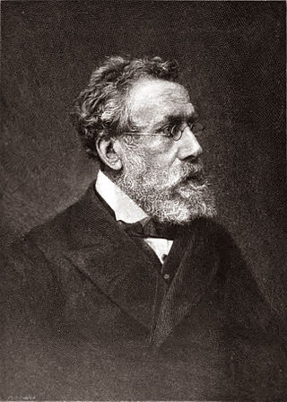
Sir Roderick Impey Murchison, 1st Baronet, was a Scottish geologist who served as director-general of the British Geological Survey from 1855 until his death in 1871. He is noted for investigating and describing the Silurian, Devonian and Permian systems.

<span class="mw-page-title-main">Bingara, New South Wales</span> Town in New South Wales, Australia

Bingara is a small town on the Gwydir River in Murchison County in the New England region of New South Wales, Australia. Bingara is currently the administrative centre for the Gwydir Shire that was created in 2003. The Gwydir River being a main highlight of the town is a main catchment of the Murray-Darling System.

<span class="mw-page-title-main">Wilcannia</span> Town in New South Wales, Australia

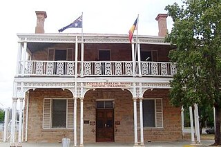
Wilcannia is a small town located within the Central Darling Shire in north western New South Wales, Australia. Located on the Darling River, the town was the third largest inland port in the country during the river boat era of the mid-19th century. At the 2016 census, Wilcannia had a population of 745.

<span class="mw-page-title-main">Murchison, New Zealand</span> Town in Tasman, New Zealand

Murchison is a town in the Tasman Region of the South Island of New Zealand. It is near the western end of the "Four Rivers Plain", at the confluence of the Buller River and the Matakitaki River. The other two rivers are the Mangles River, and the Matiri River. It is a rural service town for the surrounding mixed farming district, approximately halfway between Westport and Nelson. Murchison was named after the Scottish geologist Roderick Murchison, one of the founders of the Royal Geographical Society.

<span class="mw-page-title-main">Andrew Ramsay (geologist)</span> Scottish geologist

Sir Andrew Crombie Ramsay was a Scottish geologist.

Bluff or The Bluff may refer to:

<span class="mw-page-title-main">Buller Gorge</span>

The Buller Gorge is a gorge located in the northwest of the South Island of New Zealand. The Buller River flows through the deep canyon between Murchison and Westport. Land Information New Zealand lists two sections for the gorge, Upper Buller Gorge and Lower Buller Gorge. State Highway 6 runs alongside, but considerably above, the river through the gorge. The Stillwater - Westport Line railway also runs through the gorge.

Murchison may refer to:

<span class="mw-page-title-main">Murchison Falls</span> Waterfall on the Victoria Nile in Western Region, Uganda

Murchison Falls, also known as Kabalega Falls, is a waterfall at the apex of Lake Albert on the Victoria Nile in Uganda. At the top of Murchison Falls, the Nile forces its way through a gap in the rocks, only 7 m (23 ft) wide, and tumbles 43 m (141 ft), before flowing westward into Lake Albert. The outlet of Lake Victoria sends around 300 cubic meters per second (11,000 ft³/s) of water over the falls, squeezed into a gorge less than 10 m (33 ft) wide.

The Geographical Names Board of New South Wales, a statutory authority of the Department of Customer Service in the Government of New South Wales, is the official body for naming and recording details of places and geographical names in the state of New South Wales, Australia.

<span class="mw-page-title-main">Murchison Falls National Park</span> National park in Western Region, Uganda

Murchison Falls National Park (MFNP) is a national park in Uganda managed by the Ugandan Wildlife Authority. It is in north-western Uganda, spreading inland from the shores of Lake Albert, around the Victoria Nile, up to the Karuma Falls.

<span class="mw-page-title-main">Cusop</span> Human settlement in England

Cusop is a village and civil parish in Herefordshire, England that lies at the foot of Cusop Hill next to the town of Hay-on-Wye in Wales. It is a short walk from Hay, the distance between bus stops, and can be reached by walking or driving out of Hay towards Bredwardine, and turning right into Cusop Dingle.

<span class="mw-page-title-main">Kalbarri, Western Australia</span> Town in Western Australia

Kalbarri is a coastal town in the Mid West region located 592 km (368 mi) north of Perth, Western Australia. The town is located at the mouth of the Murchison River which has an elevation of 6 metres (20 ft). It is connected by public transport to Perth via Transwa coach services N1 and N2.

<span class="mw-page-title-main">Shire of Murchison</span> Local government area in the Mid West region of Western Australia

The Shire of Murchison covers a large area of the Murchison sub-region of the central part of Western Australia, 300 kilometres (186 mi) northeast of Geraldton. The shire and the older 'Murchison' region and goldfield are now part of the designated Mid West region. It is Australia's second least populated local government area and the only one without a town.

<span class="mw-page-title-main">Darbalara, New South Wales</span> Town in New South Wales, Australia

Darbalara is a rural community on the east bank of the junction of the Murrumbidgee River and Tumut River in the Riverina. It is situated by road, about 25 kilometres north east of Gundagai and 25 kilometres south of Coolac.

<span class="mw-page-title-main">Cowper County</span> Cadastral in New South Wales, Australia

Cowper County, New South Wales is one of the 141 Cadastral divisions of New South Wales.

<span class="mw-page-title-main">Murchison Promontory</span> Northernmost point of mainland North America

Murchison Promontory, a cape (promontory) in the northern Canadian Arctic, is the northernmost mainland point of the Americas and of Canada. Located 1,087 nautical miles from the North Pole, it is 64 km (40 mi) farther north than Point Barrow, Alaska, the northernmost point of all U.S. territory.

The Telegraph, Daily Telegraph, Sunday Telegraph and other variant names are popular names for newspapers. Newspapers with these titles include:

Bluff River may refer to:

References

  1. "Murchison County". Geographical Names Register (GNR) of NSW. Geographical Names Board of New South Wales. OOjs UI icon edit-ltr-progressive.svg