Jamison County

Last updated
Map all coordinates using: OpenStreetMap  ·  Google Maps
Download coordinates as: KML  ·  GPX
Jamison
New South Wales

Jamison NSW.PNG

Location in New South Wales
Lands administrative divisions around Jamison:
Benarba Benarba Courallie
Denham Jamison Murchison
Baradine White Nandewar

Jamison County is one of the 141 Cadastral divisions of New South Wales. It is located to the north of the Namoi River, near Wee Waa.

Namoi River river in Australia

The Namoi River, a major perennial river that is part of the Barwon catchment of the Murray–Darling basin, is located in the Northern Tablelands and North West Slopes districts of New South Wales, Australia.

Jamison County was named in honour of landowner and constitutional reformer Sir John Jamison (1776-1844). [1]

Sir John Jamison was an Australian physician, pastoralist, banker, politician, constitutional reformer and public figure.

Parishes within this county

A full list of parishes found within this county; their current LGA and mapping coordinates to the approximate centre of each location is as follows:

Local government in Australia is the third tier of government in Australia administered by the states and territories, which in turn are beneath the federal tier. Local government is not mentioned in the Constitution of Australia and two referenda in the 1970s and 1980s to alter the Constitution relating to local government were unsuccessful. Every state government recognises local government in their respective constitutions. Unlike Canada or the United States, there is only one level of local government in each state, with no distinction such as cities and counties.

Parish LGA Coordinates
Belar Narrabri Shire 29°58′54″S149°34′04″E / 29.98167°S 149.56778°E / -29.98167; 149.56778 (Belar)
Bibil Narrabri Shire 29°58′54″S149°40′04″E / 29.98167°S 149.66778°E / -29.98167; 149.66778 (Bibil)
Billaboo South Narrabri Shire 30°06′54″S149°13′04″E / 30.11500°S 149.21778°E / -30.11500; 149.21778 (Billaboo South)
Billaboo Narrabri Shire 30°00′54″S149°15′04″E / 30.01500°S 149.25111°E / -30.01500; 149.25111 (Billaboo)
Bobbiwaa Narrabri Shire 30°09′54″S149°49′04″E / 30.16500°S 149.81778°E / -30.16500; 149.81778 (Bobbiwaa)
Bolcarol Narrabri Shire 30°01′54″S149°19′04″E / 30.03167°S 149.31778°E / -30.03167; 149.31778 (Bolcarol)
Boorah Narrabri Shire 29°56′54″S149°46′04″E / 29.94833°S 149.76778°E / -29.94833; 149.76778 (Boorah)
Brigalow Narrabri Shire 29°58′54″S149°19′04″E / 29.98167°S 149.31778°E / -29.98167; 149.31778 (Brigalow)
Bulyeroi Narrabri Shire 29°53′54″S149°23′04″E / 29.89833°S 149.38444°E / -29.89833; 149.38444 (Bulyeroi)
Bunna Narrabri Shire 29°51′54″S149°15′04″E / 29.86500°S 149.25111°E / -29.86500; 149.25111 (Bunna)
Bunyah Narrabri Shire 29°54′54″S149°28′04″E / 29.91500°S 149.46778°E / -29.91500; 149.46778 (Bunyah)
Burcarroll Narrabri Shire 30°01′45″S149°25′21″E / 30.02917°S 149.42250°E / -30.02917; 149.42250 (Burcarroll)
Burren East Walgett Shire 30°04′17″S149°00′38″E / 30.07139°S 149.01056°E / -30.07139; 149.01056 (Burren East)
Burren Walgett Shire 29°54′54″S148°55′04″E / 29.91500°S 148.91778°E / -29.91500; 148.91778 (Burren)
Burrendong Narrabri Shire 29°58′54″S149°26′04″E / 29.98167°S 149.43444°E / -29.98167; 149.43444 (Burrendong)
Clements Narrabri Shire 29°49′54″S149°07′04″E / 29.83167°S 149.11778°E / -29.83167; 149.11778 (Clements)
Coolga Walgett Shire 30°14′54″S148°53′04″E / 30.24833°S 148.88444°E / -30.24833; 148.88444 (Coolga)
Coorong Narrabri Shire 29°59′54″S149°45′04″E / 29.99833°S 149.75111°E / -29.99833; 149.75111 (Coorong)
Cowimangarah Narrabri Shire 30°03′54″S150°03′04″E / 30.06500°S 150.05111°E / -30.06500; 150.05111 (Cowimangarah)
Cubbaroo North Narrabri Shire 30°11′36″S149°05′31″E / 30.19333°S 149.09194°E / -30.19333; 149.09194 (Cubbaroo North)
Cubbaroo Narrabri Shire 30°17′54″S148°58′04″E / 30.29833°S 148.96778°E / -30.29833; 148.96778 (Cubbaroo)
Dangar Narrabri Shire 29°49′54″S149°25′04″E / 29.83167°S 149.41778°E / -29.83167; 149.41778 (Dangar)
Dealwarraldi Walgett Shire 29°59′54″S149°01′04″E / 29.99833°S 149.01778°E / -29.99833; 149.01778 (Dealwarraldi)
Denham Narrabri Shire 29°59′54″S149°09′04″E / 29.99833°S 149.15111°E / -29.99833; 149.15111 (Denham)
Dewhurst Walgett Shire 30°03′54″S148°54′04″E / 30.06500°S 148.90111°E / -30.06500; 148.90111 (Dewhurst)
Dobikin Narrabri Shire 29°54′54″S149°40′04″E / 29.91500°S 149.66778°E / -29.91500; 149.66778 (Dobikin)
Doyle Narrabri Shire 30°07′54″S149°55′04″E / 30.13167°S 149.91778°E / -30.13167; 149.91778 (Doyle)
Drildool Narrabri Shire 30°14′54″S149°05′04″E / 30.24833°S 149.08444°E / -30.24833; 149.08444 (Drildool)
Eckford Narrabri Shire 29°53′54″S149°35′04″E / 29.89833°S 149.58444°E / -29.89833; 149.58444 (Eckford)
Edgeroi Narrabri Shire 29°59′54″S149°54′04″E / 29.99833°S 149.90111°E / -29.99833; 149.90111 (Edgeroi)
Galathera Narrabri Shire 30°10′54″S149°40′04″E / 30.18167°S 149.66778°E / -30.18167; 149.66778 (Galathera)
Gehan Narrabri Shire 29°48′54″S149°38′04″E / 29.81500°S 149.63444°E / -29.81500; 149.63444 (Gehan)
Gommel Narrabri Shire 30°09′54″S149°35′04″E / 30.16500°S 149.58444°E / -30.16500; 149.58444 (Gommel)
Graham Walgett Shire 30°29′54″S148°56′04″E / 30.49833°S 148.93444°E / -30.49833; 148.93444 (Graham)
Gundemain Narrabri Shire 30°04′54″S149°30′04″E / 30.08167°S 149.50111°E / -30.08167; 149.50111 (Gundemain)
Helebah Narrabri Shire 30°08′28″S149°25′03″E / 30.14111°S 149.41750°E / -30.14111; 149.41750 (Helebah)
Jamison Walgett Shire 30°10′54″S148°54′04″E / 30.18167°S 148.90111°E / -30.18167; 148.90111 (Jamison)
Keera Narrabri Shire 30°05′54″S149°45′04″E / 30.09833°S 149.75111°E / -30.09833; 149.75111 (Keera)
Long Point Narrabri Shire 30°03′42″S149°07′59″E / 30.06167°S 149.13306°E / -30.06167; 149.13306 (Long Point)
Manamoi Narrabri Shire 29°48′54″S149°45′04″E / 29.81500°S 149.75111°E / -29.81500; 149.75111 (Manamoi)
Markham Narrabri Shire 29°48′54″S149°16′04″E / 29.81500°S 149.26778°E / -29.81500; 149.26778 (Markham)
Mellburra Narrabri Shire 30°00′54″S150°00′04″E / 30.01500°S 150.00111°E / -30.01500; 150.00111 (Mellburra)
Merah North Narrabri Shire 30°11′54″S149°12′04″E / 30.19833°S 149.20111°E / -30.19833; 149.20111 (Merah North)
Merah Narrabri Shire 30°14′54″S149°12′04″E / 30.24833°S 149.20111°E / -30.24833; 149.20111 (Merah)
Meriah Narrabri Shire 30°05′54″S149°37′04″E / 30.09833°S 149.61778°E / -30.09833; 149.61778 (Meriah)
Millie Narrabri Shire 29°49′54″S149°11′04″E / 29.83167°S 149.18444°E / -29.83167; 149.18444 (Millie)
Moema Narrabri Shire 30°02′54″S149°56′04″E / 30.04833°S 149.93444°E / -30.04833; 149.93444 (Moema)
Morgan Walgett Shire 29°53′54″S149°00′04″E / 29.89833°S 149.00111°E / -29.89833; 149.00111 (Morgan)
Myall Hollow Narrabri Shire 29°54′54″S149°50′04″E / 29.91500°S 149.83444°E / -29.91500; 149.83444 (Myall Hollow)
Nowley Narrabri Shire 29°56′54″S149°11′04″E / 29.94833°S 149.18444°E / -29.94833; 149.18444 (Nowley)
Nundi Narrabri Shire 30°05′54″S149°52′04″E / 30.09833°S 149.86778°E / -30.09833; 149.86778 (Nundi)
Oreel Walgett Shire 29°44′54″S148°59′04″E / 29.74833°S 148.98444°E / -29.74833; 148.98444 (Oreel)
Oreel Walgett Shire 29°48′54″S149°02′04″E / 29.81500°S 149.03444°E / -29.81500; 149.03444 (Oreel)
Pian Narrabri Shire 30°37′54″S149°20′04″E / 30.63167°S 149.33444°E / -30.63167; 149.33444 (Pian)
Queerbri Narrabri Shire 30°08′54″S149°30′04″E / 30.14833°S 149.50111°E / -30.14833; 149.50111 (Queerbri)
Tarlee Narrabri Shire 30°07′54″S149°45′04″E / 30.13167°S 149.75111°E / -30.13167; 149.75111 (Tarlee)
Thalaba Narrabri Shire 29°51′54″S149°30′04″E / 29.86500°S 149.50111°E / -29.86500; 149.50111 (Thalaba)
Tulladunna Narrabri Shire 30°11′49″S149°22′38″E / 30.19694°S 149.37722°E / -30.19694; 149.37722 (Tulladunna)
Vickery Narrabri Shire 29°55′54″S149°05′04″E / 29.93167°S 149.08444°E / -29.93167; 149.08444 (Vickery)
Warrambool Narrabri Shire 30°11′47″S148°59′05″E / 30.19639°S 148.98472°E / -30.19639; 148.98472 (Warrambool)
Waterloo Narrabri Shire 29°52′54″S149°51′04″E / 29.88167°S 149.85111°E / -29.88167; 149.85111 (Waterloo)
Waugan Narrabri Shire 30°00′54″S149°39′04″E / 30.01500°S 149.65111°E / -30.01500; 149.65111 (Waugan)
Weeta Waa Narrabri Shire 30°14′54″S149°19′04″E / 30.24833°S 149.31778°E / -30.24833; 149.31778 (Weeta Waa)
Woolabrar Narrabri Shire 29°52′54″S149°45′04″E / 29.88167°S 149.75111°E / -29.88167; 149.75111 (Woolabrar)
Yarranbar Narrabri Shire 29°57′54″S149°15′04″E / 29.96500°S 149.25111°E / -29.96500; 149.25111 (Yarranbar)

Related Research Articles

Blue Mountains (New South Wales) Region in New South Wales, Australia

The Blue Mountains are a mountainous region and a mountain range located in New South Wales, Australia. The region borders on Sydney's metropolitan area, its foothills starting about 50 kilometres (31 mi) west of centre of the state capital. The public's understanding of the extent of the Blue Mountains is varied, as it forms only part of an extensive mountainous area associated with the Great Dividing Range. Officially the Blue Mountains region is bounded by the Nepean and Hawkesbury rivers in the east, the Coxs River and Lake Burragorang to the west and south, and the Wolgan and Colo rivers to the north. Geologically, it is situated in the central parts of the Sydney Basin.

Jamison Valley valley in New South Wales Australia

The Jamison Valley forms part of the Coxs River canyon system in the Blue Mountains of New South Wales, Australia. It is situated approximately 100 kilometres west of Sydney, capital of New South Wales, and a few kilometres south of Katoomba, the main town in the Blue Mountains.

South Creek (New South Wales) river in New South Wales, Australia

The South Creek or Wianamatta, a creek that is part of the Hawkesbury-Nepean catchment, is located on the Cumberland Plain, also referred to as Greater Western Sydney, New South Wales, Australia.

The Geographical Names Board of New South Wales, a statutory authority of the Land and Property Information division, Department of Finance and Services in the Government of New South Wales, is the official body for naming and recording details of places and geographical names in the state of New South Wales, Australia.

Wentworth Falls, New South Wales Suburb of City of Blue Mountains, New South Wales, Australia

Wentworth Falls is a town in the Blue Mountains region of New South Wales, situated approximately 100 kilometres (62 mi) west of the Sydney central business district, and about 8 kilometres (5.0 mi) east of Katoomba, Australia on the Great Western Highway, with a Wentworth Falls railway station on the Main Western line. The town is at an elevation of 867 metres (2,844 ft) AHD . At the 2016 census, Wentworth Falls had a population of 6,076.

Jamisontown, New South Wales is a suburb of Sydney, in the state of New South Wales, Australia. It is 56 kilometres west of the Sydney central business district, in the local government area of the City of Penrith, and is part of the Greater Western Sydney region. It is on the eastern side of the Nepean River, just south of Penrith and bears the name of Thomas Jamison, a pioneer landowner and First Fleet surgeon.

Thomas Jamison was a prominent surgeon, government official, mercantile trader and land owner of Sydney. Jamison was also a member of the First Fleet expedition of 11 ships which founded the Australian colony of New South Wales in 1788. Twenty years later he participated in the Rum Rebellion, which deposed the colony's governor, William Bligh.

Cook and Westmoreland was an electoral district of the Legislative Assembly in the Australian state of New South Wales in the first and second Parliaments (1856–1859), named after Cook and Westmoreland counties in the Blue Mountains, Lithgow and Oberon areas. It was largely replaced by Hartley. It elected two members simultaneously, with voters casting two votes and the first two candidates being elected.

Mount Solitary mountain in New South Wales, Australia

Mount Solitary, a mountain that is part of the Blue Mountains Range, a spur off the Great Dividing Range, is situated within the Blue Mountains National Park, New South Wales, Australia. Mount Solitary is located approximately 100 kilometres (62 mi) west of Sydney, and a few kilometres south of Katoomba, the main town in the Blue Mountains.

Wentworth Falls (waterfall)

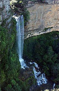
Wentworth Falls is a three-tiered waterfall fed by the Jamison Creek, near the town of Wentworth Falls in the Blue Mountains region of New South Wales, Australia. The falls are accessible via the National Pass Walking Trail and the Overcliff/Undercliff Walk. The total height of the waterfall is 187 metres (614 ft).

Jamison, California Former settlement in California, United States

Jamison is a former settlement in Plumas County, California. It lay at an elevation of 4774 feet. Jamison is located 1.25 miles (2.0 km) north-northeast of Johnsville.

Ruined Castle rock formation in the Jamison Valley area of the Blue Mountains, in New South Wales, Australia

The Ruined Castle is a famous rock formation in the Jamison Valley area of the Blue Mountains, in New South Wales, Australia. It is reached by a track which begins at the Golden Stairs descending from the Narrow Neck Plateau, south-west of Katoomba, and heads south-east towards the lower slopes of Mount Solitary. Nearby is the sealed opening of several coal mine adits. In this area is a large clearing which was once home to the mining community and is now used by campers. Used as a staging point for the south end of the aerial ropeway, there were several access points to the local coal seams used by John Britty North for retrieving coal and shale oil ore back to Malaita Point. After the collapse of the ropeway, the current walking track was developed as a horse drawn rail track to connect to the rail system used connecting Malaita Point to the Megalong Valley.

Kings Tableland

The Kings Tableland is a plateau, located in the Blue Mountains of New South Wales, Australia. The Tableland is an eroded remnant of a sandstone layer that is approximately 1,000 metres (3,300 ft) AMSL, situated immediately south of Wentworth Falls. The Tableland is the major southerly spur of the main spine of the Blue Mountains Range and forms the beginning of the Southern Escarpment, an unbroken series of tall sandstone cliffs which fringes the Jamison, Megalong, Kanimbla and Hartley Valleys.

Kedumba River river in New South Wales, Australia

The Kedumba River, a perennial river that is part of the Hawkesbury-Nepean catchment, is located in the Blue Mountains and Macarthur regions of New South Wales, Australia.

Robert Thomas Jamison was an Australian pastoralist and politician. He was a member of the New South Wales Legislative Assembly from 1856 until 1860.

Little Jamison, California Former settlement in California, United States

Little Jamison is a former settlement in Plumas County, California. It lay at an elevation of 5269 feet. Little Jamison is located on Little Jamison Creek, 6 miles (9.7 km) west of Clio. It still appeared on maps as of 1897.

Jamison, Pennsylvania Village in Pennsylvania, United States

Jamison is a small village in Warwick Township, Bucks County, Pennsylvania, United States, along Pennsylvania Route 263. Its ZIP Code is 18929.

Katoomba Falls

The Katoomba Falls is a segmented waterfall that is located close to Echo Point near Katoomba on the Kedumba River descending into the Jamison Valley located within the Blue Mountains National Park in the Blue Mountains region of New South Wales, Australia.

Bridal Veil Falls, Leura

The Bridal Veil Falls is a cascade waterfall on the Leura Falls Creek where it spills into the Jamison Valley, located south-east of Leura in the Blue Mountains region of New South Wales, Australia.

References

  1. "Jamison County". Geographical Names Register (GNR) of NSW. Geographical Names Board of New South Wales.