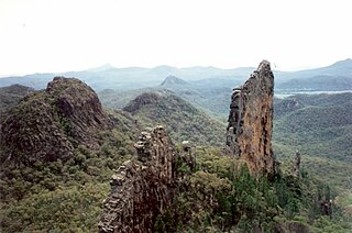
Warrumbungle National Park is a heritage listed national park located in the Orana region of New South Wales, Australia. The national park is located approximately 550 kilometres (340 mi) northwest of Sydney and contained within 23,311 hectares. The park attracts approximately 35,000 visitors per annum.

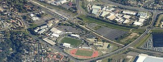
Campbelltown is a town located on the outskirts of the metropolitan area of Sydney, New South Wales, Australia. It is located in Greater Western Sydney 42 kilometres (26 mi) south-west of the Sydney central business district. Campbelltown is the administrative seat of the local government area of the City of Campbelltown. It is also acknowledged on the register of the Geographical Names Board of New South Wales as one of only four cities within the Sydney metropolitan area.

Eagle Vale is a suburb of Sydney, in the state of New South Wales, Australia. Eagle Vale is located 56 kilometres south-west of the Sydney central business district, in the local government area of the City of Campbelltown and is part of the Macarthur region.

Macquarie Fields is a suburb of Sydney, in the state of New South Wales, Australia. Macquarie Fields is located 38 kilometres south-west of the Sydney central business district, in the local government area of the City of Campbelltown and is part of the Macarthur region.

Varroville is a suburb of Sydney, in the state of New South Wales, Australia. Varroville is located 46 kilometres south-west of the Sydney central business district, in the local government area of the City of Campbelltown and is part of the Macarthur region. Varroville forms part of the scenic hills on the north-west side of the M5 South Western Motorway between Campbelltown and the Camden Valley Way. Of all Sydney suburbs, Varroville has the highest proportion of residents with PhDs.

The City of Campbelltown is a local government area in the Macarthur region of south-western Sydney, in New South Wales, Australia. The area is located about 55 kilometres (34 mi) south west of the Sydney central business district and comprises 312 square kilometres (120 sq mi).

Woodbine is a suburb of Sydney, in the state of New South Wales, Australia. It is 55 kilometres south-west of the Sydney central business district, in the local government area of the City of Campbelltown and is part of the Macarthur region. Woodbine shares the postcode of 2560 with Campbelltown.

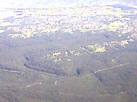
Wedderburn is a suburb of Sydney, in the state of New South Wales, Australia. Wedderburn is located 57 kilometres south-west of the Sydney central business district, in the local government area of the City of Campbelltown and is part of the Macarthur region.

St Andrews is a suburb of Sydney, in the state of New South Wales, Australia 55 kilometres south-west of the Sydney central business district, in the local government area of the City of Campbelltown. It is part of the Macarthur region.

Raby is a suburb of Sydney, in the state of New South Wales, Australia 55 kilometres south-west of the Sydney central business district, in the local government area of the City of Campbelltown. It is part of the Macarthur region.
Minto Heights is a suburb of Sydney, in the state of New South Wales, Australia 50 kilometres south-west of the Sydney central business district, in the local government area of the City of Campbelltown. It is part of the Macarthur region.
Menangle Park is a suburb in Sydney the state of New South Wales, Australia. Menangle Park is located 56 kilometres south-west of the Sydney central business district, in the local government area of the City of Campbelltown. Menangle Park is a largely rural area and is part of the Macarthur region.

Kearns is a suburb of Sydney, in the state of New South Wales, Australia 57 kilometres south-west of the Sydney central business district, in the local government area of the City of Campbelltown and is part of the Macarthur region.
Kentlyn is a suburb of Sydney, in the state of New South Wales, Australia 58 kilometres south-west of the Sydney central business district, in the local government area of the City of Campbelltown. It is part of the Macarthur region.
Leumeah is a suburb of Sydney, in the state of New South Wales, Australia 39 kilometres south-west of the Sydney central business district, in the local government area of the City of Campbelltown. It is north of the suburb of Campbelltown and is part of the Macarthur region.
Claymore is a suburb of Sydney, in the state of New South Wales, Australia. Claymore is located 54 kilometres south-west of the Sydney central business district, in the local government area of the City of Campbelltown and is part of the Macarthur region. The majority of housing in Claymore is owned by Housing NSW. The streets are named after Australian artists.
Edmondson Park is a suburb of Sydney, in the state of New South Wales, Australia. Edmondson Park is located 32 kilometres south-west of the Sydney central business district, in the local government area of the City of Liverpool. Some Southern areas near Bardia is part of City of Campbelltown LGA.

Glen Alpine is a suburb of Sydney, in the state of New South Wales, Australia. Glen Alpine is located 56 kilometres south-west of the Sydney central business district, in the local government area of the City of Campbelltown and is part of the Macarthur region.

Macarthur is a region in south-west of Sydney, in the state of New South Wales, Australia. The region includes the local government areas of the City of Campbelltown, Camden Council and Wollondilly Shire. It covers an area of 3,067 square kilometres and has a population of close to 310,000 residents. The region geographically forms the foothills between the Blue Mountains and Southern Highlands regions.

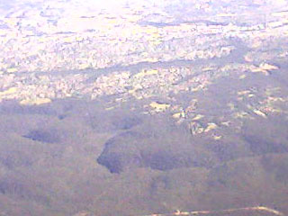
The Dharawal National Park is a protected national park that is located in the Illawarra region of New South Wales, in eastern Australia. The 6,508-hectare (16,080-acre) national park is situated between the Illawarra Range and the Georges River and is approximately 45 kilometres (28 mi) south west of Sydney. There are three entry points to the park: from the east through Darkes Forest; from the north through Wedderburn; and from the south through Appin.