Glen Alpine, New South Wales

Last updated

Glen Alpine
Sydney,  New South Wales
GlenAlpineNSWgolfcourse.jpg
Campbelltown Golf Course, Glen Alpine
Population4,559 (2016 census) [1]
Established1986
Postcode(s) 2560
Elevation108 m (354 ft)
Location56 km (35 mi) SW of Sydney
LGA(s) City of Campbelltown
State electorate(s) Campbelltown
Federal division(s) Macarthur
Suburbs around Glen Alpine:
Mount Annan Campbelltown Englorie Park
Menangle Park Glen Alpine Ambarvale
Gilead Rosemeadow Rosemeadow

Glen Alpine is a suburb of Sydney, in the state of New South Wales, Australia. Glen Alpine is located 56 kilometres south-west of the Sydney central business district, in the local government area of the City of Campbelltown and is part of the Macarthur region.

Contents

History

Glen Alpine began as a golf course estate with houses constructed mainly inside the looping design of the 18 hole course. The suburb features local shops and a tennis complex 500 metres from the golf course clubhouse. From the late 1990s, development expanded outside this ring towards the local shopping centre Macarthur Square.

In the past few years a new estate, Macarthur Gardens has been developed in the area between the 6th hole, Menangle Road and Macarthur Square. This development consists of over 50 new single and double storey houses on much smaller blocks than those of Glen Alpine. The modern style of these homes complements those of Glen Alpine. Englorie Park is another new development in this area between Glen Alpine and Ambarvale.

The name Glen Alpine dates back to the 1820s when Thomas Reddall, who lends his name to Thomas Reddall High School in neighbouring Ambarvale, built a house with that name. The house burnt down in the early 1900s and the site is now called Heritage Park on Abington Crescent. But not long after the house burnt down, property owner James Sheil built a new Glen Alpine and this house remains in Bell Tree Close. [2]

Population

In the 2016 Census, there were 4,559 people in Glen Alpine. 69.9% of people were born in Australia. The next most common country of birth was England at 4.1%. 75.7% of people spoke only English at home. Other languages spoken at home included Arabic at 3.2%. The most common responses for religion were Catholic 35.7%, Anglican 17.4% and No Religion 13.2%. [1]

Housing

The suburb is low density residential with blocks between 800sqm and 1900sqm. Most homes are less than 30 years old and are styled as modern heritage though other designs are common.

According to the 2016 census, 98.7 percent of privately occupied Glen Alpine homes were detached housing. Most were: owned outright (39.4%), or in the process of being bought (52.6%). The median home loan repayment of $2,167 per month was higher than the national median of $1,755. [1]

Golf course

Campbelltown Golf Course is an 18-hole championship course located at Glen Alpine. It is listed as 5764m long, has a par of 70 and is open to the public. [3]


Notable residents

Related Research Articles

<span class="mw-page-title-main">Campbelltown, New South Wales</span> City in New South Wales, Australia

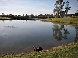
Campbelltown is a suburb located on the outskirts of the metropolitan area of Sydney, New South Wales, Australia. It is located in Greater Western Sydney 53 kilometres (33 mi) south-west of the Sydney central business district by road. Campbelltown is the administrative seat of the local government area of the City of Campbelltown. It is also acknowledged on the register of the Geographical Names Board of New South Wales as one of only four cities within the Sydney metropolitan area.

<span class="mw-page-title-main">Eagle Vale, New South Wales</span> Suburb of Sydney, New South Wales, Australia

Eagle Vale is a suburb of Sydney, in the state of New South Wales, Australia. Eagle Vale is located 56 kilometres south-west of the Sydney central business district, in the local government area of the City of Campbelltown and is part of the Macarthur region.

<span class="mw-page-title-main">Macquarie Fields, New South Wales</span> Suburb of Sydney, New South Wales, Australia

Macquarie Fields is a suburb of Sydney, in the state of New South Wales, Australia. Macquarie Fields is located 38 kilometres south-west of the Sydney central business district, in the local government area of the City of Campbelltown and is part of the Macarthur region.

<span class="mw-page-title-main">Ambarvale, New South Wales</span> Suburb of Sydney, New South Wales, Australia

Ambarvale is a suburb of south-western Sydney in the state of New South Wales, Australia. Ambarvale is located 55 kilometres south-west of the Sydney central business district, in the local government area of the City of Campbelltown and is part of the Macarthur region. The suburb is predominantly residential and contains a mix of public and private housing.

<span class="mw-page-title-main">Macarthur railway station</span> Railway station in Sydney, New South Wales, Australia

Macarthur railway station is located on the Main South line, serving the Sydney suburb of Campbelltown. It is served by Sydney Trains T8 Airport & South and NSW TrainLink Southern Highlands Line services. It is the southern extremity of the electrified Sydney Trains network.

<span class="mw-page-title-main">City of Campbelltown (New South Wales)</span> Local government area in New South Wales, Australia

The City of Campbelltown is a local government area in the Macarthur region of south-western Sydney, in New South Wales, Australia. The area is located about 55 kilometres (34 mi) south west of the Sydney central business district and comprises 312 square kilometres (120 sq mi).

<span class="mw-page-title-main">Woodbine, New South Wales</span> Suburb of Sydney, New South Wales, Australia

Woodbine is a suburb of Sydney, in the state of New South Wales, Australia. It is 55 kilometres south-west of the Sydney central business district, in the local government area of the City of Campbelltown and is part of the Macarthur region. Woodbine shares the postcode of 2560 with Campbelltown.

<span class="mw-page-title-main">St Andrews, New South Wales</span> Suburb of Sydney, New South Wales, Australia

St Andrews is a suburb of Sydney, in the state of New South Wales, Australia 55 kilometres south-west of the Sydney central business district, in the local government area of the City of Campbelltown. It is part of the Macarthur region.

<span class="mw-page-title-main">Minto, New South Wales</span> Suburb of Sydney, New South Wales, Australia

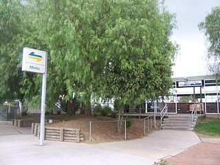
Minto is a suburb of Sydney, in the state of New South Wales, Australia. Minto is located 50 kilometres south-west of the Sydney central business district, in the local government area of the City of Campbelltown and is part of the Macarthur region.

<span class="mw-page-title-main">Kearns, New South Wales</span> Suburb of Sydney, New South Wales, Australia

Kearns is a suburb of Sydney, in the state of New South Wales, Australia 57 kilometres south-west of the Sydney central business district, in the local government area of the City of Campbelltown and is part of the Macarthur region.

<span class="mw-page-title-main">Kentlyn, New South Wales</span> Suburb of Sydney, New South Wales, Australia

Kentlyn is a suburb of Sydney, in the state of New South Wales, Australia 58 kilometres south-west of the Sydney central business district, in the local government area of the City of Campbelltown. It is part of the Macarthur region.

<span class="mw-page-title-main">Leumeah, New South Wales</span> Suburb of Sydney, New South Wales, Australia

Leumeah is a suburb of Sydney, in the state of New South Wales, Australia 52 kilometres south-west of the Sydney central business district, in the local government area of the City of Campbelltown. It is north of the suburb of Campbelltown and is part of the Macarthur region.

<span class="mw-page-title-main">Rosemeadow, New South Wales</span> Suburb of Sydney, New South Wales, Australia

Rosemeadow is a suburb of Sydney, in the state of New South Wales, Australia. Rosemeadow is located 56 kilometres south-west of the Sydney central business district, in the local government area of the City of Campbelltown and is part of the Macarthur region.

<span class="mw-page-title-main">Blairmount, New South Wales</span> Suburb of Sydney, New South Wales, Australia

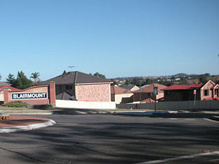
Blairmount is a suburb of Sydney, in the state of New South Wales, Australia 58 kilometres south-west of the Sydney central business district, in the local government area of the City of Campbelltown. It is part of the Macarthur region. Its main road is Clydesdale Drive and its other streets are named after horse breeds.

<span class="mw-page-title-main">Bradbury, New South Wales</span> Suburb of Sydney, New South Wales, Australia

Bradbury is a suburb of Sydney, in the state of New South Wales, Australia. Bradbury is located 54 kilometres south-west of the Sydney central business district, in the local government area of the City of Campbelltown and is part of the Macarthur region.

<span class="mw-page-title-main">Claymore, New South Wales</span> Suburb of Sydney, New South Wales, Australia

Claymore is a suburb of Sydney, in the state of New South Wales, Australia. Claymore is located 54 kilometres south-west of the Sydney central business district, in the local government area of the City of Campbelltown and is part of the Macarthur region. The majority of housing in Claymore is owned by Housing NSW. The streets are named after Australian artists.

<span class="mw-page-title-main">Englorie Park, New South Wales</span> Suburb of Sydney, New South Wales, Australia

Englorie Park is a suburb of Sydney, in the state of New South Wales, Australia. Englorie Park is located 55 kilometres south-west of the Sydney central business district, in the local government area of the City of Campbelltown and is part of the Macarthur region.

Macquarie Links is a suburb of Sydney, in the state of New South Wales, Australia. Macquarie Links is located 42 kilometres (26 mi) south-west of the Sydney central business district, in the local government area of the City of Campbelltown and is part of the Macarthur region.

<span class="mw-page-title-main">Macarthur, New South Wales</span> Region in South Western Sydney

Macarthur is a region in the south-west part of the Greater Sydney area, in the state of New South Wales, Australia. The region includes the local government areas of the City of Campbelltown, Camden Council, and Wollondilly Shire. It covers an area of 3,067 square kilometres and has a population of close to 310,000 residents. The region geographically forms the foothills between the Blue Mountains and Southern Highlands regions.

<span class="mw-page-title-main">Thomas Reddall High School</span> School in Australia

Thomas Reddall High School is a government-funded co-educational comprehensive school, located in Ambarvale, a south-western suburb of Sydney, New South Wales, Australia.

References

  1. 1 2 3 Australian Bureau of Statistics (27 June 2017). "Glen Alpine (State Suburb)". 2016 Census QuickStats. Retrieved 5 May 2018. OOjs UI icon edit-ltr-progressive.svg
  2. "History of Glen Alpine". Campbelltown City Council. Archived from the original on 13 October 2009. Retrieved 6 June 2009.
  3. Campbelltown Golf Club. "The Course" . Retrieved 13 July 2014.
  4. "The bizarre day of a Glen Alpine man". The Sydney Morning Herald. 7 February 2006. Retrieved 4 May 2013.

34°05′24″S150°47′06″E / 34.090°S 150.785°E / -34.090; 150.785