
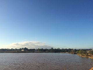
The Georges River, also known as Tucoerah River, is an intermediate tide-dominated drowned valley estuary, that is located in Sydney, Australia. The Georges River is located south and south-west from the Sydney central business district, with the mouth of the river being at Botany Bay.

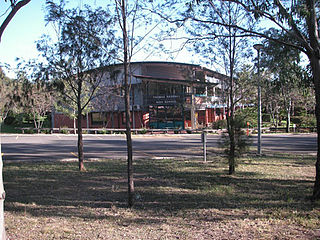
Campbelltown is a suburb located on the outskirts of the metropolitan area of Sydney, New South Wales, Australia. It is located in Greater Western Sydney 53 kilometres (33 mi) south-west of the Sydney central business district by road. Campbelltown is the administrative seat of the local government area of the City of Campbelltown. It is also acknowledged on the register of the Geographical Names Board of New South Wales as one of only four cities within the Sydney metropolitan area.

Camden is a historic town and suburb of Sydney, New South Wales, located 65 kilometres south-west of the Sydney central business district. Camden was the administrative centre for the local government area of Camden Council until July 2016 and is a part of the Macarthur region.
Ambarvale is a suburb of south-western Sydney in New South Wales, Australia. Ambarvale is located 55 kilometres southwest of the Sydney central business district, in the local government area of the City of Campbelltown, and is part of the Macarthur region. The suburb is predominantly residential and contains a mix of public and private housing.

Macarthur railway station is located on the Main Southern line, serving the Sydney suburb of Campbelltown. It is served by Sydney Trains T8 Airport & South and NSW TrainLink Southern Highlands Line services. It is the southern extremity of the electrified Sydney Trains network.

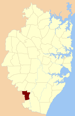
The City of Campbelltown is a local government area in the Macarthur region of south-western Sydney, in New South Wales, Australia. The area is located about 55 kilometres (34 mi) south west of the Sydney central business district and comprises 312 square kilometres (120 sq mi).
Leumeah is a suburb of Sydney, in the state of New South Wales, Australia 52 kilometres south-west of the Sydney central business district, in the local government area of the City of Campbelltown. It is north of the suburb of Campbelltown and is part of the Macarthur region.
Spring Farm is a suburb of the Macarthur Region of Sydney in the state of New South Wales, Australia in Camden Council. It is on the east side of the Nepean River. Until recently, it was mainly farmland with a winery, an electricity substation and the Spring Farm Advanced Resource Recovery Facility, but it is currently in the process of suburban redevelopment.

Rosemeadow is a suburb of Sydney, in the state of New South Wales, Australia. Rosemeadow is located 56 kilometres south-west of the Sydney central business district, in the local government area of the City of Campbelltown and is part of the Macarthur region.
Gilead is a suburb of Sydney, in the state of New South Wales, Australia. Gilead is located 58 kilometres south-west of the Sydney central business district, in the local government area of the City of Campbelltown and is part of the Macarthur region.

Macarthur is a region in the south-west part of the Greater Sydney area, in the state of New South Wales, Australia. The region includes the local government areas of the City of Campbelltown, Camden Council, and Wollondilly Shire. It covers an area of 3,067 square kilometres and has a population of close to 310,000 residents. The region geographically forms the foothills between the Blue Mountains and Southern Highlands regions.

Menangle Park railway station is located on the Main Southern line in New South Wales, Australia. It serves the town of Menangle Park, opening on 26 September 1937.

Menangle is a village in the Macarthur region of New South Wales, Australia.

The Main Southern Railway is a major railway in New South Wales, Australia. It runs from Sydney to Albury, near the Victorian border. The line passes through the Southern Highlands, Southern Tablelands, South West Slopes and Riverina regions.

Douglas Park is a town of the Macarthur Region in New South Wales, Australia in Wollondilly Shire. It is near the Hume Highway, the F5 Freeway and on the Main Southern railway line. Its station is served by NSW TrainLink's Southern Highlands Line. It is about 80 km southwest of Sydney. In 2016, Douglas Park had a population of 1,362.

The Camden Park Estate incorporating the Belgenny Farm is a heritage-listed large working historical farm located at Elizabeth Macarthur Avenue, in the outer south-western Sydney suburb of Camden South, New South Wales, Australia. It was designed by Henry Kitchen in c. 1800, John Verge in c. 1835 and A. J. Onslow in c. 1888 and built from 1819 to 1840 by John Macarthur in c. 1800, James English and Sons in c. 1888 and John Sulman c. 1895. The property is owned by Belgenny Farm Trust and Camden Park Preservation Committee. It was added to the New South Wales State Heritage Register on 22 December 2006. Today, part of the original estate contains the Elizabeth Macarthur Agricultural Institute; having originally served as a commercial sheep station and horticultural farm for the Macarthur family since the early 1800s.
Manangle Parish, Cumberland is one of the 57 parishes of Cumberland County, New South Wales, a cadastral unit for use on land titles. Its eastern boundary is the Georges River, and western boundary the Nepean River. It includes the southern Sydney suburbs of Menangle Park, Gilead, Rosemeadow and part of Glen Alpine. Major roads in the area include the South Western Freeway, Menangle Road and Appin Road.
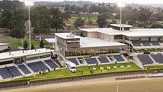
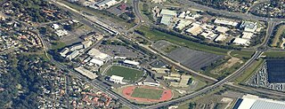
Menangle Park Paceway, known for sponsorship reasons as Tabcorp Park, Menangle, is a harness racing track operating in Menangle Park, New South Wales, Australia. The New South Wales Harness Racing Club conducts meetings at the Paceway. The New South Wales Harness Racing Club trading as Club Menangle Trackside, is located within the Paceway grounds off Racecourse Avenue. Major extensions to the club at the licensed historic premises previously known as the Horse and Jockey Inn just outside the paceway grounds, opened in September 2019.

Sugarloaf Farm is a heritage-listed former dairy, wheat farming and pastoral property and now residence and horse riding venue located at Menangle Road, Gilead, City of Campbelltown, New South Wales, Australia. It was designed and built from 1835. It is also known as Mt Huon. The property is owned by the New South Wales Department of Planning and Infrastructure. It was added to the New South Wales State Heritage Register on 2 April 1999.

Glenlee is a heritage-listed former dairy farm, pastoral property and hay production and now olive farm, private home and pastoral property at Glenlee Road, Menangle Park, City of Campbelltown, New South Wales, Australia. It was designed by Henry Kitchen and built from 1824 to 1859 by Robert Gooch and Nathaniel Payton. It is also known as Glenlee, outbuildings, garden & gatelodge. It was added to the New South Wales State Heritage Register on 2 April 1999.


