Campbelltown is a city located on the outskirts of the metropolitan area of Sydney, New South Wales, Australia. It is located in Greater Western Sydney 53 kilometres (33 mi) south-west of the Sydney central business district by road. Campbelltown is the administrative seat of the local government area of the City of Campbelltown. It is also acknowledged on the register of the Geographical Names Board of New South Wales as one of only four cities within the Sydney metropolitan area.

Georges Hall, a suburb of local government area City of Canterbury-Bankstown, is located 24 kilometres south-west of the Sydney central business district in the state of New South Wales, Australia, and is part of the South-western Sydney region.

Camden is a historic town and suburb of Sydney, New South Wales, located 65 kilometres south-west of the Sydney central business district. Camden was the administrative centre for the local government area of Camden Council until July/August 2016 and is a part of the Macarthur region.
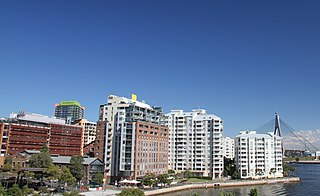
Pyrmont is an inner-city suburb of Sydney, in the state of New South Wales, Australia 2 kilometres south-west of the Sydney central business district in the local government area of the City of Sydney. It is also part of the Darling Harbour region. As of 2011, it is Australia's most densely populated suburb.

Bella Vista is located 33 kilometres north-west of the Sydney central business district and is part of The Hills Shire. It is a suburb in the Hills District of Greater Western Sydney and is in the state of New South Wales, Australia. Bella Vista's Norwest Business Park is home to several Fortune 500 companies, a number of shopping centres, high-rise buildings, and industrial and recreational spaces.

Camden Council is a local government area in the Macarthur region of Sydney, in the state of New South Wales, Australia. The area is located south west of the Sydney central business district and comprises 201 square kilometres (78 sq mi) with an estimated population at the 2021 census of 119,325. The mayor of Camden is Cr. Ashleigh Cagney, a member of the Labor Party.

Rosehill is a suburb of Sydney, in the state of New South Wales, Australia. Rosehill is located 18 kilometres west of the Sydney central business district in the local government area of the City of Parramatta and is part of the Greater Western Sydney region.

Narellan is a suburb of Sydney, New South Wales. Narellan is located 60 kilometres south-west of the Sydney central business district, in the local government area of Camden Council and is part of the Macarthur region.
Birchgrove is a suburb in the Inner West of Sydney, in the state of New South Wales, Australia. Birchgrove is located five kilometres west of the Sydney central business district, in the local government area of the Inner West Council.

Camden South is a suburb of the Macarthur Region of Sydney in the state of New South Wales, Australia in Camden Council. It is to the immediate south of Camden, New South Wales and shares the same postcode 2570.

Castlereagh is a suburb of Sydney, in the state of New South Wales, Australia. Castlereagh is 67 kilometres (42 mi) north-west of the Sydney central business district, in the local government area of the City of Penrith and is part of the Greater Western Sydney region.
Catherine Field is a suburb of Sydney and part of the Macarthur Region in the state of New South Wales, Australia. Catherine Field is 43 kilometres south-west of the Sydney central business district, in the local government area of Camden Council.
Cobbitty is a semi-rural town of the Macarthur Region near the town of Camden, southwest of Sydney, in the state of New South Wales, Australia. The area is mostly farmland with a population of around 2000.
Gilead is a suburb of Sydney, in the state of New South Wales, Australia. Gilead is located 58 kilometres south-west of the Sydney central business district, in the local government area of the City of Campbelltown and is part of the Macarthur region.

Harris Park is a suburb of Greater Western Sydney, in the state of New South Wales, Australia. Harris Park is located 19 kilometres west of the Sydney central business district in the local government area of the City of Parramatta and is part of the Greater Western Sydney region. Harris Park has a plurality of Indian and Hindu population, both making up the largest ethnic and religious group. As a result a precinct in the suburb is informally sometimes referred to as 'Little India'.
Harrington Park is a suburb of the Macarthur Region of Sydney in the state of New South Wales, Australia in Camden Council. Once a grand estate, owned by the Fairfax family, it has recently been developed as a residential suburb. Harrington Park House has been restored by Harrington Estates who manage the property on behalf of the Fairfax Estate.

Horningsea Park is a suburb of Sydney, in the state of New South Wales, Australia. Horningsea Park is located 39 kilometres south-west of the Sydney central business district, in the local government area of the City of Liverpool and is part of the Greater Western Sydney region.
Oran Park is a suburb of south-west Sydney, within the Macarthur Region, in the state of New South Wales, Australia in Camden Council. The suburb is often used as an example of urban sprawl.

Menangle is a village in the Macarthur region of New South Wales, Australia.

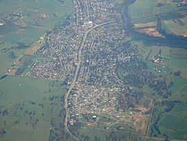
Picton is a small town in the Macarthur Region of New South Wales, Australia, in the Wollondilly Shire, in south-western Sydney. The town is located approximately 90 kilometres south-west of the Sydney CBD, close to Camden and Campbelltown. It is also the administrative centre of Wollondilly Shire.