
The Blue Mountains National Park is a protected national park that is located in the Blue Mountains region of New South Wales, in eastern Australia. The 267,954-hectare (662,130-acre) national park is situated approximately 80 kilometres (50 mi) west of the Sydney CBD, and the park boundary is quite irregular as it is broken up by roads, urban areas and areas of private property. Despite the name mountains, the area is an uplifted plateau, dissected by a number of larger rivers. The highest point in the park is Mount Werong at 1,215 metres (3,986 ft) above sea level; while the low point is on the Nepean River at 20 metres (66 ft) above sea level as it leaves the park.

The Nattai National Park is a protected area located in the Macarthur and Southern Highlands regions of New South Wales, Australia. The 48,984-hectare (121,040-acre) area is situated approximately 150 kilometres (93 mi) southwest of the Sydney central business district and primarily encompasses the valley of the Nattai River, which is surrounded by sandstone cliffs. Part of the Southern Highlands Shale Forest and Woodland, the park is covered in dry sclerophyll (hard-leafed) forest – mostly eucalypt, and has frequent forest fires. As of May 2024, the park has no facilities.

Coal mining is the process of extracting coal from the ground or from a mine. Coal is valued for its energy content and since the 1880s has been widely used to generate electricity. Steel and cement industries use coal as a fuel for extraction of iron from iron ore and for cement production. In the United Kingdom and South Africa, a coal mine and its structures are a colliery, a coal mine is called a "pit", and above-ground mining structures are referred to as a "pit head". In Australia, "colliery" generally refers to an underground coal mine.

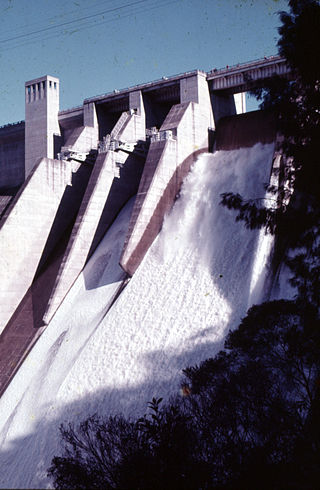
Lake Burragorang is a man-made reservoir in the lower Blue Mountains of New South Wales, Australia, serving as a major water supply for greater metropolitan Sydney. The dam impounding the lake, the Warragamba Dam, is located approximately 60 kilometres (37 mi) southwest of the Sydney central business district.

Megalong Valley is part of the Blue Mountains of New South Wales, Australia. It is located west of Katoomba. On its eastern side, the valley is separated from the Jamison Valley by Narrow Neck Plateau. The Shipley Plateau overlooks part of the valley.

Mittagong is a town located in the Southern Highlands of New South Wales, Australia, in Wingecarribee Shire. The town acts as the gateway to the Southern Highlands when coming from Sydney. Mittagong is situated at an elevation of 635 metres (2,083 ft). The town is close to Bowral, Berrima, Moss Vale and the Northern Villages such as Yerrinbool and Colo Vale. Moreover, Mittagong is home to many wineries of the Southern Highlands which has been a recent growing wine and cellar door region.

Mining in Australia has long been a significant primary sector industry and contributor to the Australian economy by providing export income, royalty payments and employment. Historically, mining booms have also encouraged population growth via immigration to Australia, particularly the gold rushes of the 1850s. Many different ores, gems and minerals have been mined in the past and a wide variety are still mined throughout the country.
Fassifern is a suburb of the City of Lake Macquarie, Greater Newcastle in New South Wales, Australia, located west of Lake Macquarie. The Sydney–Newcastle railway line runs through Fassifern railway station, which is a major station along the line. There used to be a branch line between Fassifern Station and nearby Toronto, but this has been replaced by a bus service, aptly named "The Train".
West Wallsend is a suburb and small town in the City of Lake Macquarie, Greater Newcastle in New South Wales, Australia. It is near the Sydney-Newcastle Freeway and the western suburbs of Newcastle.
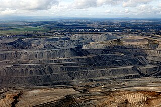
Coal is mined in every state of Australia. The largest black coal resources occur in Queensland and New South Wales. About 70% of coal mined in Australia is exported, mostly to eastern Asia, and of the balance most is used in electricity generation. In 2019-20 Australia exported 390 Mt of coal and was the world's largest exporter of metallurgical coal and second largest exporter of thermal coal. While only employing 50,000 mining jobs nationally coal provides a rich revenue stream for governments.

The Gwabegar railway line is a railway line in the Central West and North West Slopes of New South Wales, Australia, which passes through the towns of Mudgee, Gulgong, Dunedoo, Coonabarabran and terminates at Gwabegar.

The Oaks is a town in the Macarthur Region of New South Wales, Australia in Wollondilly Shire on the south western edge of the Sydney Basin. The Oaks is located 82 kilometres (51 mi) south-west of Sydney via the Hume Highway, 13 kilometres (8 mi) west of Camden and 290m above sea-level. At the 2016 census, The Oaks and the surrounding area had a population of 2,525.
The Warragamba River, a river that is part of the Hawkesbury-Nepean catchment, is located in the Macarthur region of New South Wales, Australia.

The Nattai River, a perennial river that is part of the Hawkesbury-Nepean catchment, is located in the Southern Highlands region of New South Wales, Australia.
The Tonalli River, a perennial river that is part of the Hawkesbury-Nepean catchment, is located in the Blue Mountains region of New South Wales, Australia.

Burragorang or Burragorang Valley is a locality in the Macarthur Region of New South Wales, Australia, in Wollondilly Shire. It is home to Lake Burragorang, which is impounded by Warragamba Dam. It is partially encompassed by Blue Mountains National Park and Nattai National Park.
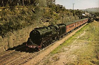
The coastal coal-carrying trade of New South Wales involved the shipping of coal—mainly for local consumption but also for export or coal bunkering—by sea to Sydney from the northern and southern coal fields of New South Wales. It took place in the 19th and 20th centuries. It should not be confused with the export coal trade, which still exists today. There was also an interstate trade, carrying coal and coke to other Australian states that did not have local sources of black coal.
The Metropolitan Colliery is a coal mine located near Helensburgh, New South Wales owned by Peabody Energy. It was opened by in 1887 by the Cumberland Coal & Iron Mining Company. In 1965, the mine was purchased by Australian Iron & Steel. A proposed sale to South32 in 2016 was abandoned after the Australian Competition & Consumer Commission refused to approve it.
Lidsdale is a locality within the City of Lithgow Local Government Area of New South Wales, Australia. It lies to the north of Wallerawang. Its area, as defined for postal and statistical purposes, includes the historic locality of Kerosene Vale and the small rural areas known as Springvale and Angus Place. In 2021, its population was 471.
The Mining and Energy Union (MEU) is Australia's main trade union in the coal industry, which includes mines, power stations and ports. It also covers workers in the metalliferous mining and exploration industries, as well as specific classes of workers working in the oil, gas, nuclear, chemical production and power generation industries. The MEU is affiliated with the Australian Council of Trade Unions (ACTU) and the Australian Labor Party (ALP).
