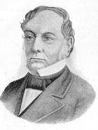
When the division was proclaimed, the division partially overlapped with the New South Wales Legislative Assemblyelectoral district of the same name. The member for the colonial electoral district at the time, William Lyne of the Protectionist Party, was also the Premier of the colony. He resigned as Premier and from the Legislative Assembly to contest the federal seat at the first federal election in 1901, subsequently winnning the seat at the election and becoming the first member for the federal seat.
After election, Lyne served as a cabinet minister in various roles (except when the Protectionist Party was not in government between 1904 and 1905). He served as a minister until 1908 when the Deakin government lost support in parliament. In 1909, the Protectionist Party and Anti-Socialist Party merged to form the Liberal Party (not to be confused with the modern Liberal Party), but Lyne refused to join the merged party and sat as an independent. He was re-elected as an independent at the 1910 election, when Labor won and formed majority government. However, at the 1913 election, Lyne was defeated by the Liberal Party's Robert Patten. Patten would serve as the member for Hume for two terms, during which, the Liberal Party merged with the National Labor Party to become the Nationalist Party.
Patten retired at the 1917 election, and he was succeeded by Franc Falkiner, also from the Nationalist Party. Falkiner had transferred from the neighbouring Division of Riverina. He did not recontest Hume at the following 1919 election, and the division was won by Labor's Parker Moloney, becoming the first Labor member of Hume. Moloney had relocated from Victoria and had transferred from the adjacent federal Victorian division of Division of Indi. In 1931, Moloney was defeated by Thomas Collins of the Country Party (later National Party), who also became the first Country member for Hume.
For the next 40 years, the division of Hume regularly changed hands between the Country and Labor parties, with all sitting members during this period defeated in general elections. In particular, the division alternated between Labor's Arthur Fuller and Country's Charles Anderson for twenty years between 1943 and 1963. Labor last won the seat at the 1972 election, with Frank Olley being the most recent Labor member for Hume (as of 2026[update]). He was defeated by Country Party member Stephen Lusher at the following 1974 election.
At the 1984 election, the Liberal Party member for Farrer, Wal Fife, contested Hume after a redistribution transferred Wagga Wagga from Farrer to Hume. This created a three-cornered contest between Lusher, Fife and the Labor candidate, splitting the conservative vote. Out of the three, Lusher had the lowest primary vote count which was narrowly behind Fife's. The preferences for Lusher were mostly distributed to Fife, and Fife won the seat to become the first member for Hume from the current Liberal Party.
Fife held the seat until his retirement at the 1993 election, when National regained the seat with the election of John Sharp. Sharp had transferred from the Division of Gilmore, which lost majority of its area to Hume following a redistribution. Sharp was involved in a parliamentary travel allowances affair in 1997 and retired at the 1998 election. In the election, Liberal Party regained the seat with the election of Alby Schultz, who was previously the state member for Burrinjuck. Since that election, the division of Hume had only been won by the Liberal Party.
Since the 2013 federal election, the member for Hume is Angus Taylor of the Liberal Party, who became party leader and opposition leader in 2026.
Boundaries
Since 1984, federal electoral division boundaries in Australia have been determined at redistributions by a redistribution committee appointed by the Australian Electoral Commission. Redistributions occur for the boundaries of divisions in a particular state, and they occur every seven years, or sooner if a state's representation entitlement changes or when divisions of a state are malapportioned.[1]
When the division was created in 1900, it was located in southern NSW on the Victorian border and encompassed the town of Albury. In the 1906 redistribution, it lost Cootamundra but gained Wagga Wagga, but regained Cootamundra in the 1913 redistribution. Until 1949, the division had largely covered similar areas, occasionally gaining small areas to the east in redistributions, such as Yass. It began to border the Australian Capital Territory in 1934.[2]
The first major change to the division's boundaries was in 1949, when it lost its western half comprising Wagga Wagga and Albury to the new Division of Farrer.[3] However, it gained some areas further to the north-west and north-east in the surroundings of Cootamundra and Yass. By 1968, the division had already expanded north to include the areas south of Orange (but excluding Orange), such as Cowra. It expanded further north in 1977 and gained areas from the Division of Calare, such as Forbes, but stopping short of Parkes.[4][2]
In 1984, the division lost its northern half (such as Cowra), as well as majority of the areas it had gained in 1977 (such as Forbes), to the new divisions of Parkes and Gilmore.[5][6] It also regained Wagga Wagga in the south-west from Farrer, only to lose it eight years later in 1992 to the re-created Division of Riverina.[3][7] In that same year, the division shifted east and was expanded to cover what was previously a large part of Gilmore. This included areas that was lost to Gilmore in 1984 such as Cowra and Boorowa, as well as additional areas in the Southern Highlands such as Goulburn.[6] In 2000, the division shifted further east and lost Cootamundra which it covered since federation (except between 1906 and 1913) to Riverina. Instead, it gained further areas in the Southern Highlands from the Division of Macarthur, such as Picton, Appin, Mittagong and Bowral, but did not cover the nearby Moss Vale.[8] In 2006, it lost Picton and Appin but gained Moss Vale.[2]
In 2009, the division lost Mittagong, Bowral and Moss Vale to the Division of Throsby, but regained Picton.[9] It also regained areas to the north-west and south-west, including Cootamundra and Cowra. In 2016, it lost its western one-third of its area including Yass and Cootamundra. Instead, it only gained very small areas in its north-east, regaining Appin and expanding into Camden in the outskirts of Sydney. It also no longer bordered the Australian Capital Territory.[2]
In the 2024 redistribution, the division underwent another major boundary change. It was significantly shrunk in area and lost at least three-quarters of its area in the south-west, including Goulburn and Boorowa, to the divisions of Eden-Monaro, Riverina and Whitlam.[10][7][11] It retained only the areas surrounding Bargo, Picton, Appin and Camden. It also expanded slightly to cover more south-western Sydney suburbs, including Oran Park, Leppington, Bradfield, Badgerys Creek and the under-construction Western Sydney International Airport at the time.[2]
Between the 2009 and 2024 redistributions, the seat had shrunk from 33,637km2 (12,987sqmi) to 2,674km2 (1,032sqmi), an approximately 92% decrease.[12][13]
Since the 2025 federal election, the division is located in the outer south-west Sydney suburbs and some nearby rural areas. It includes Wollondilly Shire, most of Camden Council, the western part of the City of Liverpool and a southern part of the City of Penrith.[13] The division shares most of its boundaries outside of Sydney with the western, southern and most of the eastern boundaries of Wollondilly Shire.[14]
Since 2016, there is no overlap with the area it originally covered at federation, and the division had effectively moved north-east towards Sydney gradually over time.[15][2]
This page is based on this Wikipedia article Text is available under the CC BY-SA 4.0 license; additional terms may apply. Images, videos and audio are available under their respective licenses.