
Yass Valley Council is a local government area in the Southern Tablelands region of New South Wales, Australia. The area is located adjacent to the Hume and Barton Highways and the Main Southern railway line.
Murrumbidgee is a former electoral district of the Legislative Assembly in the Australian state of New South Wales, named after the Murrumbidgee River.

The South Western Slopes, also known as the South West Slopes, is a region predominantly in New South Wales, Australia. It covers the lower inland slopes of the Great Dividing Range, extending from north of Dunedoo through central NSW and into northeast Victoria, meeting its southwestern end around Beechworth. More than 90% of the region is in the state of New South Wales and it occupies about 10% of that state.

Gundagai Shire was a local government area in the Riverina region of New South Wales, Australia. On 12 May 2016, Gundagai Shire was abolished and merged with the neighbouring Cootamundra Shire to establish Cootamundra-Gundagai Regional Council.

Boorowa Council was a local government area in the South West Slopes region of New South Wales, Australia. The LGA was located adjacent to the Lachlan Valley Way and included Boorowa and the small towns of Rye Park, Rugby, Frogmore and Reids Flat. Burrowa LGA was formed on 1 September 1944 through the amalgamation of Murrungal Shire and the Municipality of Burrowa.

Young Shire was a local government area in the South West Slopes region of New South Wales, Australia. The Shire was located adjacent to the Olympic Highway.

Harden Shire was a local government area in the South West Slopes region of New South Wales, Australia. The Shire included the twin towns of Harden and Murrumburrah and the small towns of Galong, Jugiong, Wombat and Kingsvale.

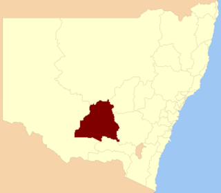
Cootamundra Shire was a local government area in the Riverina region of New South Wales, Australia. The Shire was located adjacent to the Olympic Highway, the Burley Griffin Way and the Main South railway line. The Shire included the town of Cootamundra and the small towns of Stockinbingal, Brawlin and Wallendbeen and the locality of Frampton. The Shire was created on 1 April 1975 by the amalgamation of Jindalee Shire and the Municipality of Cootamundra.

Goulburn is an electoral district of the Legislative Assembly in the Australian state of New South Wales. It is represented by Wendy Tuckerman of the Liberal Party.

Katrina Ann Hodgkinson is an Australian former politician. She is the former Federal Vice President of the National Party of Australia and a former Australian Member of Parliament. She was a member of the New South Wales Legislative Assembly, representing Cootamundra for The Nationals from 28 March 2015 to 1 September 2017, and Burrinjuck from 27 March 1999 to 27 March 2015.
Yass was an electoral district of the Legislative Assembly in the Australian state of New South Wales between 1894 and 1920. It included the town of Yass. It largely replaced the electoral district of Yass Plains. In 1920, with the introduction of proportional representation, it was absorbed along with Burrangong into Cootamundra. It was recreated in 1930 and replaced by Burrinjuck in 1950.
Temora was an electoral district for the Legislative Assembly in the Australian State of New South Wales from 1927 to 1981, including the town of Temora.
Boorowa was an electoral district of the Legislative Assembly in the Australian State of New South Wales from 1880 to 1904, including the town of Boorowa. Its name was spelt "Booroowa" from 1899 to 1901. It was abolished in the 1904 re-distribution of electorates following the 1903 New South Wales referendum, which required the number of members of the Legislative Assembly to be reduced from 125 to 90, and was largely absorbed by Yass, with the balance going to the new district of Burrangong.

Cootamundra is an electoral district of the Legislative Assembly in the Australian state of New South Wales.
Wynyard was an electoral district for the Legislative Assembly in the Australian State of New South Wales from 1904 to 1913, including the town of Tumut and named after Wynyard County. It replaced all of the abolished district of Tumut and part of the abolished district of Gundagai. Its only member was Robert Donaldson. The Federal Capital Territory was removed from New South Wales in 1911 and Wynyard was abolished in the 1912 redistribution. Most of the district, including the town of Tumut was absorbed by the district of Yass and the balance was distributed between the surrounding districts of Cootamundra, Wagga Wagga and Albury.
Burrangong was an electoral district of the Legislative Assembly in the Australian state of New South Wales created in the 1904 re-distribution of electorates following the 1903 New South Wales referendum, which required the number of members of the Legislative Assembly to be reduced from 125 to 90. It was named after Burrangong station, the first squatting run in the Young area and consisted of parts of the abolished districts of Boorowa, Grenfell and Young. In 1920, with the introduction of proportional representation, it was absorbed along with Yass into Cootamundra.
Young was an electoral district for the Legislative Assembly in the Australian state of New South Wales, named after and including the town of Young. It elected two members between 1880 and 1894 and one member from 1894 to 1904, when it was replaced by Burrangong. The sitting member George Burgess (Labor) successfully contested Burrangong. In 1920, with the introduction of proportional representation, Burrangong was absorbed by the three member district of Cootamundra. Proportional representation was abandoned in 1927 and Young was recreated. It was abolished in 1981 and the district was split with Young being absorbed by Burrinjuck while the towns of Cowra and Forbes were absorbed by a re-created Lachlan.
Burrinjuck, an electoral district of the Legislative Assembly in the Australian state of New South Wales was created in 1950 and abolished in 2015.
Cootamundra, an electoral district of the Legislative Assembly in the Australian state of New South Wales, was created in 1904 and was abolished in 1941, returning one member until 1920, three members from 1920 to 1927 and one member from 1927 to 1941. It was recreated in 2015.
Burrangong, an electoral district of the Legislative Assembly in the Australian state of New South Wales was created in 1904 and abolished in 1920.
