Electoral district of Murrumbidgee

Last updated

Location in New South Wales Murrumbidgee NSW State Electoral District.png
Location in New South Wales

Murrumbidgee is a former electoral district of the Legislative Assembly in the Australian state of New South Wales, named after the Murrumbidgee River.

Contents

History

Until its abolition, Murrumbidgee and Parramatta were the only electorates to have existed continuously since the first Legislative Assembly election in 1856, although before 1913 it was called The Murrumbidgee. It elected two members between 1856 and 1859, one member between 1859 and 1880, two members between 1880 and 1885, three members between 1885 and 1894 and one member between 1894 and 1920. Voters cast a vote for each vacancy. Between 1920 and 1927, it absorbed parts of Lachlan and Ashburnham and elected three members under proportional representation. From 1927 until its abolition at the 2015 election, it elected one member.

At the 2007 election it included most of Junee Shire (including Junee, Wantabadgery, Harefield, Old Junee and Junee Reefs) Temora Shire, Coolamon Shire, Bland Shire, part of Lachlan Shire (including Condobolin, Lake Cargelligo and Burcher), Narrandera Shire, Leeton Shire, the City of Griffith, Murrumbidgee Shire and part of Carrathool Shire (including Rankins Springs and Carrathool). [1]

Murrumbidgee was abolished at the 2015 election with the recreated electoral district of Cootamundra absorbing Junee Shire, Temora Shire, Coolamon Shire, Bland Shire and Narrandera Shire, the recreated electoral district of Murray absorbing Leeton Shire, the City of Griffith, Murrumbidgee Shire and Carrathool and the Electoral district of Barwon absorbing Lachlan Shire. [2]

Members for Murrumbidgee

Two members (1856–1859)
MemberPartyTermMemberPartyTerm
  John Hay None1856–1859  George Macleay None1856–1859
Single-member (1859–1880)
MemberPartyTerm
  William Macleay None1859–1874
  William Forster None1875–1876
  Joseph Leary None1876–1880
Two members (1880–1885)
MemberPartyTermMemberPartyTerm
  James Douglas None1880–1882  George Loughnan None1880–1885
  Auber Jones None1882–1885
Three members (1885–1894)
MemberPartyTermMemberPartyTermMemberPartyTerm
  James Gormly None1885–1887  George Dibbs None1885–1887  Alexander Bolton None1885–1887
  Protectionist 1887–1894  Ind. Free Trade 1887–1889  John Gale Protectionist 1887–1889
  Protectionist 1889–1894  David Copland Protectionist 1889–1891
  Arthur Rae Labor 1891–1894
  Independent Labor 1894–1894
Single-member (1894–1920)
MemberPartyTerm
  Thomas Fitzpatrick Protectionist 1894–1901
  Progressive 1901–1904
  Patrick McGarry Labor 1904–1917
  Nationalist 1917–1920
  Ind. Nationalist 1920–1920
Three members (1920–1927)
MemberPartyTermMemberPartyTermMemberPartyTerm
  Arthur Grimm Nationalist 1920–1925  Ernest Buttenshaw Progressive 1920–1925  Martin Flannery Labor 1920–1927
  Edmund Best Nationalist 1925–1927  Country 1925–1927
Single-member (1927–2015)
MemberPartyTerm
  Martin Flannery Labor 1927–1932
  Robert Hankinson Country 1932–1941
  George Enticknap Independent Labor 1941–1944
  Labor 1944–1965
  Al Grassby Labor 1965–1969
  Lin Gordon Labor 1970–1984
  Adrian Cruickshank National 1984–1999
  Adrian Piccoli National 1999–2015

Election results

2011 New South Wales state election: Murrumbidgee [3]
PartyCandidateVotes%±%
National Adrian Piccoli 31,41473.4+10.2
Labor William Wood8,43119.7-12.2
Greens George Benedyka1,5773.7-1.2
Christian Democrats Fiona Bushby1,3623.2+3.2
Total formal votes42,78497.6-0.2
Informal votes1,0702.4+0.2
Turnout 43,85492.1
Two-party-preferred result
National Adrian Piccoli 32,26077.9+11.8
Labor William Wood9,14922.1-11.8
National hold Swing +11.8

Related Research Articles

<span class="mw-page-title-main">Narrandera</span> Town in New South Wales, Australia

Narrandera, until around 1949 also spelled "Narandera", is a town located in the Riverina region of southern New South Wales, Australia. The town lies on the junction of the Newell and Sturt highways, adjacent to the Murrumbidgee River, and it is considered the gateway to the Murrumbidgee Irrigation Area. At the 2016 census, Narrandera had a population of 3,746 people.

<span class="mw-page-title-main">Olympic Highway</span> Highway in New South Wales

Olympic Highway is a 317-kilometre (197 mi) rural road in the central western and south-eastern Riverina regions of New South Wales, Australia. It services rural communities, links Hume Highway with Mid-Western Highway, and provides part of an alternate road link between Sydney and Albury via Bathurst and Cowra as well as servicing Wagga Wagga, linking with Sturt Highway.

<span class="mw-page-title-main">Riverina</span> Region in New South Wales, Australia

The Riverina is an agricultural region of south-western New South Wales, Australia. The Riverina is distinguished from other Australian regions by the combination of flat plains, warm to hot climate and an ample supply of water for irrigation. This combination has allowed the Riverina to develop into one of the most productive and agriculturally diverse areas of Australia. Bordered on the south by the state of Victoria and on the east by the Great Dividing Range, the Riverina covers those areas of New South Wales in the Murray and Murrumbidgee drainage zones to their confluence in the west.

<span class="mw-page-title-main">Leeton, New South Wales</span> Town in New South Wales, Australia

Leeton is a town located in the Riverina region of New South Wales, Australia. Leeton is situated in the Murrumbidgee Irrigation Area. It is the administrative centre of the Leeton Shire Council local government area, which includes neighbouring suburbs, towns and localities such as Yanco, Wamoon, Whitton, Gogeldrie, Stanbridge and Murrami. Situated in one of the most productive farming regions in the state, the town was designed by Walter Burley Griffin and purpose-built for the irrigation schemes announced by the New South Wales government in the early 20th century. The Leeton Shire possesses numerous citrus, rice, cotton, grape, walnut and wheat farms. Leeton is known as Australia's Rice Capital, as well as The Heart of SunRice Country, as it is home to the headquarters of SunRice corporation, one of Australia's largest food exporters. Other industry includes Arnott's Biscuits, the Daily Drinks Company, JBS Australia, Webster Limited, and Murrumbidgee Irrigation Limited. Tony Reneker is the current mayor of Leeton.

<span class="mw-page-title-main">Leeton Shire</span> Local government area in New South Wales, Australia

Leeton Shire is a local government area in the Riverina region of New South Wales, Australia. The Shire is located adjacent to the Murrumbidgee River and falls within the Murrumbidgee Irrigation Area.

<span class="mw-page-title-main">Irrigation Way</span>

Irrigation Way is a major rural road that runs approximately 85 kilometres (53 mi) through the Murrumbidgee Irrigation Area in south western New South Wales, Australia.

<span class="mw-page-title-main">Murrumbidgee Irrigation Area</span> Food production system in south east Australia

<span class="mw-page-title-main">Electoral district of Burrinjuck</span>

Burrinjuck was an electoral district of the Legislative Assembly in the Australian state of New South Wales from 1950 to 2015.

Lachlan was an electoral district of the Legislative Assembly in the Australian state of New South Wales. During the first two Parliaments (1856–1859), there was an electorate in the same area called Lachlan and Lower Darling, named after the Lachlan and Darling Rivers. Lachlan was created in 1859 and abolished in 1880, partly replaced by Forbes. In 1894 Forbes was abolished and Lachlan was recreated. In 1920 Lachlan and Ashburnham were absorbed into Murrumbidgee and elected three members under proportional representation. At the end of proportional representation in 1927, Lachlan was recreated. It was abolished in 1950, recreated in 1981 and abolished in 2007.

<span class="mw-page-title-main">South Western Slopes</span> Bioregion in New South Wales, Australia

The South Western Slopes, also known as the South West Slopes, is a region predominantly in New South Wales, Australia. It covers the lower inland slopes of the Great Dividing Range, extending from north of Dunedoo through central NSW and into northeast Victoria, meeting its southwestern end around Beechworth. More than 90% of the region is in the state of New South Wales and it occupies about 10% of that state.

<span class="mw-page-title-main">Goolgowi</span> Town in New South Wales, Australia

Goolgowi is a small town located in western New South Wales, Australia, around 650 kilometres (400 mi) west of Sydney via the Mid-Western Highway and is the administrative centre of Carrathool Shire. At the 2016 census, Goolgowi had a population of 402.

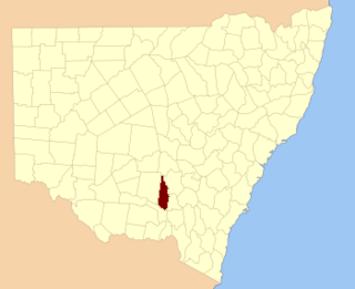
Temora was an electoral district for the Legislative Assembly in the Australian State of New South Wales from 1927 to 1981, including the town of Temora.

<span class="mw-page-title-main">Electoral district of Cootamundra</span>

Cootamundra is an electoral district of the Legislative Assembly in the Australian state of New South Wales.

Sturt was an electoral district of the Legislative Assembly in the Australian state of New South Wales in the Broken Hill area. It was a single member electorate from 1889 to 1920.

Cobar was an electoral district of the Legislative Assembly in the Australian state of New South Wales which was named after the town of Cobar. It was first created in 1894 and abolished in 1920. Cobar was recreated in 1930 and abolished in 1968.

Ashburnham was an electoral district of the Legislative Assembly in the Australian state of New South Wales, originally created in 1894 in the Parkes area and named after Ashburnham County. In 1920, with the introduction of proportional representation, it was absorbed into Murrumbidgee, along with Lachlan. It was recreated in 1927 and abolished in 1950.

<span class="mw-page-title-main">Hay railway line</span> New South Wales, Australia

The Hay railway line is a partly closed railway line in New South Wales, Australia. The line branches from the Main South line at Junee, and passes in a westwards direction through the towns of Coolamon and Narrandera to Yanco. The first train arrived in Hay on 4 July 1882. The line beyond Yanco to Hay is now closed, although the section to Willbriggie remained open for grain haulage until 2004. At Yanco, the still-open Yanco to Griffith line branches off in a northwesterly direction to Griffith.

<span class="mw-page-title-main">Electoral district of Murray</span> Electoral district in Australia

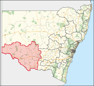
Murray is an electoral district in the Australian state of New South Wales.

<span class="mw-page-title-main">Ernest Buttenshaw</span> Politician in New South Wales, Australia

Ernest Albert Buttenshaw was an Australian politician and member of the New South Wales Legislative Assembly from 1917 until 1932. He was a member of the Nationalist Party of Australia until 1920, when he helped to establish the Progressive Party. After 1925 he was a member of its successor, the Country Party. He was the party leader between 1925 and 1932 and held a number of government ministries.

The South West District Football League was a major Australian rules football competition which ran from 1910 until 1981 in the Riverina region of New South Wales.

References

  1. "Murrumbidgee". New South Wales Electoral Commission . Retrieved 30 September 2011.
  2. "Electoral Districts Commissioners' Report" (PDF). New South Wales Electoral Commission. 18 September 2013. Archived from the original (PDF) on 6 January 2014. Retrieved 6 January 2014.
  3. Antony Green. "2011 New South Wales Election: Analysis of Results" (PDF). NSW Parliamentary Library. Archived from the original (PDF) on 24 October 2012. Retrieved 4 December 2011.