The Snowy Mountains, known informally as "The Snowies", is an IBRA subregion and the highest mountain range on the continent of mainland Australia. It contains the Australian mainland's highest mountain, Mount Kosciuszko, which reaches to a height of 2,228 m (7,310 ft) above sea level. The range also contains the five highest peaks on the Australian mainland, all of which are above 2,100 m (6,890 ft). They are located in southern New South Wales and are part of the larger Australian Alps and Great Dividing Range, experiencing large natural snowfalls every winter. Snow normally falls during June, July, August and early September, with the snow cover melting by late spring. The Tasmanian highlands makes up the other (major) alpine region present in Australia.
Kalgoorlie is a city in the Goldfields-Esperance region of Western Australia, located 595 km (370 mi) east-northeast of Perth at the end of the Great Eastern Highway. It is sometimes referred to as Kalgoorlie-Boulder, as the surrounding urban area includes the historic townsite of Boulder and the local government area is the City of Kalgoorlie-Boulder.

Toronto is a lakeside suburb within the city of Lake Macquarie in New South Wales, Australia, approximately 28 kilometres (17 mi) from Newcastle's central business district and is a commercial hub for the sprawling suburbs on the western shore of the lake. It is one of the major centres in the City of Lake Macquarie LGA.

Wiluna is a small town in the Mid West region of Western Australia. It is situated on the edge of the Western Desert at the gateway to the Canning Stock Route and Gunbarrel Highway. It is the service centre of the local area for the local Martu people, the pastoral industry, the Wiluna Gold Mine, and many more people who work on other mines in the area on a "fly-in/fly-out" basis. Wiluna's climate is hot and dry, with an annual rainfall of 258 millimetres (10.2 in). Mean maximum temperatures range from 19 °C (66 °F) in July, to 38 °C (100 °F) in January.

Bulli is a northern suburb of Wollongong situated on the south coast of New South Wales, Australia. Bulli is possibly derived from an Aboriginal word signifying "double or two mountains", but other derivations have been suggested.

Orange is a city in the Central Tablelands region of New South Wales, Australia. It is 254 km (158 mi) west of the state capital, Sydney [206 km (128 mi) on a great circle], at an altitude of 862 metres (2,828 ft). Orange had an estimated urban population of 40,493 as of June 2018 making the city a significant regional centre. A significant nearby landmark is Mount Canobolas with a peak elevation of 1,395 m (4,577 ft) AHD and commanding views of the district.

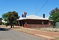
West Wyalong is the main town of the Bland Shire in the Riverina region of New South Wales, Australia. Located 467 kilometres (290 mi) west of Sydney and 262 m (860 ft) above sea level, it is situated on the crossroads of the Newell Highway between Melbourne and Brisbane, and the Mid-Western Highway between Sydney and Adelaide.
Pambula is a town in Bega Valley Shire on the far south coast of New South Wales, Australia 473 kilometres (294 mi) south of Sydney via the Princes Highway. At the 2016 census, Pambula had a population of 970 people.

Mittagong is a town located in the Southern Highlands of New South Wales, Australia, in Wingecarribee Shire. The town acts as the gateway to the Southern Highlands when coming from Sydney. Mittagong is situated at an elevation of 635 metres (2,083 ft). The town is close to Bowral, Berrima, Moss Vale and the Northern Villages such as Yerrinbool and Colo Vale. Moreover, Mittagong is home to many wineries of the Southern Highlands which has been a recent growing wine and cellar door region.

Temora is a town in the north-east of the Riverina area of New South Wales, 418 kilometres (260 mi) south-west of the state capital, Sydney. At the 2016 census the urban population of Temora was 4,054.

Lake Cowal is the largest inland lake in New South Wales, Australia. The lake is ephemeral, being fed by the small Bland Creek and by the occasional flooding of the Lachlan River. Despite this, it retains a considerable amount of water in about 70% of years.

Jamieson is a small town in Victoria, Australia. It is located at the junction of the Goulburn River and Jamieson River, 193 kilometres (120 mi) north-east of Melbourne. The name is believed to have been derived from George Jamieson, a shepherd who grazed sheep in the area in the 1850s. At the time of the 2016 census, Jamieson had a population of 301.
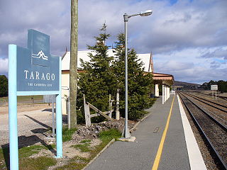
Tarago is a town in the Southern Tablelands of New South Wales, Australia in Goulburn Mulwaree Council. Part of the defined locality, which includes a large area of grazing country, is on the eastern shore of Lake George in the area of the Queanbeyan–Palerang Regional Council. The town is situated 39 kilometres south of the city of Goulburn and 69 kilometres northeast of Canberra, the capital city of Australia. It is located on the Goulburn-Braidwood road. The town is notable for recent renewable energy projects in the surrounding districts.
Speers Point is a suburb within, and the location of the council seat of the City of Lake Macquarie local government area in New South Wales, Australia. It is 17 kilometres (10.6 mi) west-southwest of the city of Newcastle on the northern shore of Lake Macquarie, in Cockle and Warners Bays, between the suburbs of Cardiff and Warners Bay.

Lachlan Shire is a local government area in the Central West region of New South Wales, Australia. The Shire is located adjacent to the Lachlan River, the Lachlan Valley Way and the Broken Hill railway line.

Mulwala is a town in the Federation Council local government area in the Riverina district of New South Wales, Australia. The town is situated on Lake Mulwala, an artificial lake formed by the damming of the Murray River. At the 2006 census, Mulwala had a population of 1,986 people. The town's name is derived from an aboriginal word for 'rain'.

Ross is a historic town in the Midlands of the state of Tasmania in Australia. On the Macquarie River, Ross is located 78 km south of Launceston and 117 km north of Hobart. The town is listed on the Register of the National Estate and is noted for its historic bridge, original sandstone buildings and convict history.

Ungarie is a town in New South Wales, Australia which is the second major town of the Bland Shire, located in the Central West region of New South Wales. It is located 513 kilometres (319 mi) west of Sydney and 615 kilometres (382 mi) north of Melbourne, between the towns of West Wyalong and Lake Cargelligo and is situated 262 metres (860 ft) above sea level. The town's name is derived from an Indigenous Australian word meaning "thigh". Ungarie has the lowest median house price in Australia at $58,500 as of October 2013.

The Burcher railway line is a partly closed railway line in New South Wales, Australia, branching from the Cootamundra to Lake Cargelligo line at Wyalong Central.

Gilgai is a town in the Northern Tablelands region of New South Wales, Australia The village is situated 10 km south of Inverell, New South Wales on Thunderbolts Way and is in Inverell Shire. At the 2006 census, Gilgai had a population of 289 people. The name Gilgai is an Aboriginal word meaning 'waterhole'.