Gosford is a waterfront city at the northern end of Brisbane Water on the Central Coast in the state of New South Wales, Australia. The Gosford waterfront is known for its boating and scenic views on the shores of Brisbane Water. Gosford is the main commercial hub and gateway of the Central Coast. It is situated approximately 77 km (48 mi) north of Sydney and 86 km (53 mi) south of Newcastle. Gosford is located in the local government area of the Central Coast Council.

The Central Coast is a peri-urban region lying on the Pacific Ocean in northern-eastern New South Wales, Australia. The region is situated north of Sydney, which is filled with subtropical national parks, forests and also encompasses the major coastal waterways of Brisbane Water, Tuggerah Lakes and southern Lake Macquarie. The region's hinterland, which has fertile valleys, rural farmland and wineries, and also includes the Watagan Mountains. The Central Coast is known for its regional coastal towns like Terrigal, The Entrance, Ettalong Beach, Budgewoi and Bateau Bay with resorts and holiday parks, which feature many expansive beaches and lagoons with surfing and coastal tracks, as well as scenic views. Gosford is the main commercial hub and gateway.

The City of Gosford was a local government area that was located in the Central Coast region in the state of New South Wales, Australia. The incorporation of Gosford dates back to 1886 when the Town of Gosford was proclaimed as the Borough of Gosford, becoming the Municipality of Gosford from 1906. In 1908, the Gosford Municipality merged into Erina Shire which covered the remaining Central Coast area outside of Gosford, but regained its independence in 1936. From 1 January 1947, local government in the Central Coast region was reorganised, creating Gosford Shire and Wyong Shire, and the final boundaries of Gosford City Council date from this period. From 1 January 1980, Gosford Shire was granted city status, becoming the City of Gosford. On 12 May 2016 the Minister for Local Government amalgamated the City of Gosford and Wyong Shire Councils. The Central Coast Council was established on the same day, covering the combined areas.
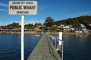
Saratoga is a residential south-eastern village and suburb of the Central Coast region of New South Wales, Australia, located on a peninsula of Brisbane Water and part of the Central Coast Council local government area. The suburb is characterised by its largely settled shoreline, with houses extending up coastal slopes to the base of the tall hills that comprise the core of the peninsula.

Kincumber is a south-eastern suburb of the Central Coast region of New South Wales, Australia, nested between the Kincumba Mountain Reserve and the Kincumber Broadwater and located 87 kilometres (54 mi) north of Sydney via the Sydney-Newcastle Freeway (F3). It is part of the Central Coast Council local government area. It is on The Guringgai land
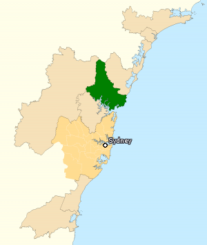
The Division of Robertson is an Australian electoral division in the state of New South Wales.
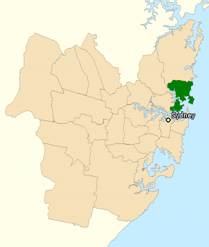
The Division of Warringah is an Australian electoral division in the state of New South Wales.

Terrigal is a coastal town on the Central Coast of New South Wales, Australia, located 12 kilometres (7 mi) east of Gosford on the Pacific Ocean. It is part of the Central Coast Council local government area.

Gosford railway station is located on the Main Northern line in New South Wales, Australia. It serves the Central Coast city of Gosford, opening on 15 August 1887.
Gosford is an electoral district of the New South Wales Legislative Assembly in Australia. The electorate covers the southern and western parts of the Central Coast Council in the Central Coast region, including central Gosford and Woy Woy.

The Electoral district of Wakehurst is an electoral district of the Legislative Assembly in the Australian state of New South Wales. It covers a significant part of Sydney's Northern Beaches as well as parts of the Forest District. Created in 1962, it has been won by the Liberal Party at all but three elections over the last half-century.

Avoca Beach is a coastal suburb of the Central Coast region of New South Wales, Australia, about 95 kilometres (59 mi) north of Sydney. Avoca Beach is primarily a residential suburb, Avoca Beach is also a popular tourist destination. Avoca Beach is known for its surfing and state (regional) surf competitions. It is located within the Central Coast Council local government area.
The Central Coast Division of Country Rugby League is a rugby league competition based on the Central Coast of New South Wales between Sydney and Newcastle. The competition was founded in 1947 as a junior competition for the Newcastle club, Lakes United. The competition rapidly expanded and grew, so much so that in 1967, it was upgraded to full membership of the Country Rugby League as Group 12. In 1981, it was upgraded and renamed Central Coast Division. The division covers the entire region of the Central Coast from Woy Woy and Umina in the south up to Budgewoi and Gwandalan in the north.

Christopher "Chris" Peter Hartcher is an Australian politician. He was a member of the New South Wales Legislative Assembly from 1988 to 2015, representing the electorates of Gosford (1988–2007) and Terrigal (2007–2015). He represented the Liberal Party for most of his career, serving as its deputy state leader from 2002 to 2003, and in the O'Farrell Ministry as Minister for Resources and Energy, Special Minister of State and Minister for the Central Coast. In 2013, he resigned to sit as an independent following his implication in an ongoing Independent Commission Against Corruption inquiry, and retired at the 2015 state election.

The Avoca Lake, formerly known as Avoca Lagoon and as Bulbararing Lagoon, is an intermittently closed intermediate saline coastal lagoon that is located on the Central Coast of New South Wales, Australia. Avoca Lake is located between the beachside settlements of North Avoca and Avoca Beach, and adjacent to the Pacific Ocean, about 85 kilometres (53 mi) north of Sydney.

The Central Coast Council is a local government area in the Central Coast region of New South Wales, Australia. It is adjacent to the Pacific Highway, Central Coast Highway, the Northern railway line and the Pacific Ocean. The council was formed on 12 May 2016 following the merger of the Gosford City and Wyong Shire Councils.
This article provides information on the under-16 premiership deciders of rugby league competitions held on the Central Coast of New South Wales, Australia. The match details sub-section details the individual point-scorers in a match, where known. In 1996 and all but one season since 2003, a second tier under-16 competition has also been held.
This article provides information on the under 16 premiership deciders of rugbyleague competitions held on the Central Coast of New South Wales, Australia. The match details sub-section details the individual point-scorers in a match, where known.
This article provides information on the under 19 premiership deciders of rugby league competitions held on the Central Coast of New South Wales, Australia. The match details sub-section details the individual point-scorers in a match, where known.