
Leichhardt is a suburb in the Inner West of Sydney, in the state of New South Wales, Australia. Leichhardt is located 5 kilometres west of the Sydney central business district (CBD) and is the administrative centre for the local government area (LGA) of the Inner West Council. The suburb is bordered by Haberfield to the west, Annandale to the east, Lilyfield to the north and Petersham, Lewisham and Stanmore to the south.

Trigg is a suburb of Perth, Western Australia. Its local government area is the City of Stirling. Trigg Island is a small island off the coast of the suburb of Trigg.
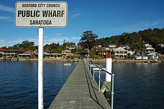
Saratoga is a residential south-eastern village and suburb of the Central Coast region of New South Wales, Australia, located on a peninsula of Brisbane Water and part of the Central Coast Council local government area. The suburb is characterised by its largely settled shoreline, with houses extending up coastal slopes to the base of the tall hills that comprise the core of the peninsula.
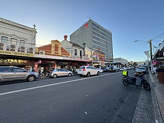
Strathfield is a suburb in Western Sydney, in the state of New South Wales, Australia. It is located 12 kilometres west of the Sydney central business district and is the administrative centre of the Municipality of Strathfield. A small section of the suburb north of the railway line lies within the City of Canada Bay, while the area east of The Boulevard lies within the Municipality of Burwood. North Strathfield and Strathfield South are separate suburbs to the north and south, respectively.
Kallaroo is one of the four 'Whitfords' suburbs in Perth that resulted from the Western Australian Government rezoning large areas of coastal land for development in 1969.

Toongabbie is a suburb of Sydney, in the state of New South Wales, Australia. One of the oldest suburbs in Sydney, Toongabbie is located approximately 30 kilometres west of the Sydney central business district and is part of the Greater Western Sydney region. Toongabbie is split between the local government areas of the City of Parramatta, the City of Blacktown and Cumberland Council. The suburb is often locally referred to as "Toonie", "Toonga Bay" and "Bayside".

Nerang is a town and suburb in the City of Gold Coast, Queensland, Australia. In the 2016 census, Nerang had a population of 16,864 people.

Warnervale is a town in the Central Coast Council local government area in the Central Coast region in the state of New South Wales, Australia. It lies approximately 101 km north of Sydney, located west of Tuggerah Lake, a large shallow coastal lake, and just north of Wyong.

Erina is a suburb located in the Central Coast region of New South Wales, Australia. Erina is the largest commercial hub of the Central Coast and is home to the largest single level shopping centre in the Southern Hemisphere that is called Erina Fair. It is part of the Central Coast Council local government area.
Watanobbi is a suburb of the Central Coast region of New South Wales, Australia. It is part of the Central Coast Council local government area, and is part of the Warnervale development precinct. Watanobbi is almost entirely surrounded by the Porters Creek wetlands, which goes to the Tuggerah Lakes catchment, located just west of Tuggerah Lake.
Bateau Bay is a suburb of the Central Coast region of New South Wales, Australia. "Bateau" is French for "boat."
Hillarys is a northern coastal suburb of Perth, the capital city of Western Australia, in the local government area of the City of Joondalup. It is part of the Whitfords precinct, and is located 21 km north-northwest of Perth's central business district via Mitchell Freeway and Hepburn Avenue.
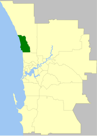
The City of Joondalup is a local government area in Perth, Western Australia. Its central business district is located in the suburb Joondalup, and it includes the town centres of Hillarys and Warwick.

Tuggerah is a large commercial hub and a suburb of the Central Coast region of New South Wales, Australia. It is located approximately 91 km north of Sydney and 68 km south of Newcastle. It is the second largest business hub, major shopping area and financial district for the Central Coast after Erina.

Killarney Vale is a suburb of the Central Coast region of New South Wales, Australia, located approximately 5 kilometres south of The Entrance. It is part of the Central Coast Council local government area.
Kulnura is a rural suburb of the Central Coast region of New South Wales, Australia. It is located north of Mangrove Mountain along the George Downes Drive. Kulnura is located within the Central Coast Council local government area.

East Bunbury is an inner southeastern suburb of Bunbury, Western Australia 4 kilometres (2.5 mi) from the centre of Bunbury. It is located within the local government area of the City of Bunbury.
Greengrove is a locality of and town within the Central Coast region of New South Wales, Australia, near Mangrove Mountain and adjoining the Popran National Park about 40 kilometres (25 mi) west of Gosford. It is part of the Central Coast Council local government area.
Crangan Bay is a coastal suburb of the Central Coast region of New South Wales, Australia, located between Budgewoi and Swansea on the bay of the same name. It is part of the Central Coast Council local government area.

Riverview is a suburb on the Lower North Shore of Sydney, New South Wales, Australia. Riverview is located 9 kilometres north-west of the Sydney central business district, in the local government area of the Municipality of Lane Cove. It is situated on the northern side of the Lane Cove River, at the head of Tambourine Bay; the foreshore is occupied by Tambourine Bay Park. Riverview is primarily a residential area.

