Buff Point is a suburb of the Central Coast region of New South Wales, Australia. It is part of the Central Coast Council local government area.
Colongra is a suburb of the Central Coast region of New South Wales, Australia, on the banks of Lake Munmorah. It is part of the Central Coast Council local government area.
Magenta is a coastal location of the Central Coast region of New South Wales, Australia. It is part of the Central Coast Council local government area, and contains a significant portion of the Wyrrabalong National Park.
Wallarah is a sparsely populated suburb of the Central Coast region of New South Wales, Australia. It is part of the Central Coast Council local government area.

Wyong Creek is a suburb of the Central Coast region of New South Wales, Australia. It is part of the Central Coast Council local government area.

Box Head is a coastal locality in the Central Coast Council local government area located on the Central Coast of New South Wales, Australia. It is within Bouddi National Park which includes the island of Lion Island.

Mount Elliot is a semi-rural locality of the Central Coast region of New South Wales, Australia, 9 kilometres (6 mi) east-north-east of Gosford's central business district. It is part of the Central Coast Council local government area.
Mount White is a rural locality on the Central Coast of New South Wales, Australia. Mount White is located 58 kilometres (36 mi) north of Sydney and 21 kilometres (13 mi) south-west of Gosford. The locality is adjacent to the Pacific Motorway. It is part of the Central Coast Council local government area.
Upper Mangrove is a suburb of the Central Coast region of New South Wales, Australia, located about 22 kilometres (14 mi) upstream and north of Spencer along Mangrove Creek. It is part of the Central Coast Council local government area.
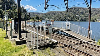
Wondabyne is a road-inaccessible locality located in the Central Coast region of New South Wales, Australia, and is part of the Central Coast Council local government area. The river that surrounds Wondabyne is called "Mullet Creek."
Budgewoi Peninsula is a coastal suburb of the Central Coast region of New South Wales, Australia, on a narrow peninsula between Munmorah Lake and the Pacific Ocean. It is part of the Central Coast Council local government area.
Greengrove is a locality of and town within the Central Coast region of New South Wales, Australia, near Mangrove Mountain and adjoining the Popran National Park about 40 kilometres (25 mi) west of Gosford. It is part of the Central Coast Council local government area.
Lower Mangrove is a suburb of the Central Coast region of New South Wales, Australia, located about 8 kilometres (5 mi) upstream and north of Spencer along Mangrove Creek. It is part of the Central Coast Council local government area.
Durren Durren is a suburb of the Central Coast region of New South Wales, Australia. It is part of the Central Coast Council local government area.
Palm Grove is a suburb of the Central Coast region of New South Wales, Australia. It is located about 10 kilometres (6 mi) upstream along Ourimbah Creek from the town of Ourimbah. It is part of the Central Coast Council local government area.
Halloran is a sparsely populated suburb of the Central Coast region of New South Wales, Australia, located off the Sydney-Newcastle Freeway between Wyong and Morisset. It is part of the Central Coast Council local government area.
Bushells Ridge is a northern locality of the Central Coast region of New South Wales, Australia. It is part of the Central Coast Council local government area.
Crangan Bay is a coastal suburb of the Central Coast region of New South Wales, Australia, located between Budgewoi and Swansea on the bay of the same name. It is part of the Central Coast Council local government area.
Moonee is a coastal suburb of the Central Coast region of New South Wales, Australia. It is part of the Central Coast Council local government area.
This page is based on this
Wikipedia article Text is available under the
CC BY-SA 4.0 license; additional terms may apply.
Images, videos and audio are available under their respective licenses.

