
The Central Coast is a peri-urban region lying on the Pacific Ocean in northern-eastern New South Wales, Australia. The region is situated north of Sydney, which is filled with subtropical national parks, forests and also encompasses the major coastal waterways of Brisbane Water, Tuggerah Lakes and southern Lake Macquarie. The region's hinterland, which has fertile valleys, rural farmland and wineries, and also includes the Watagan Mountains. The Central Coast is known for its regional coastal towns like Terrigal, The Entrance, Ettalong Beach, Budgewoi and Bateau Bay with resorts and holiday parks, which feature many expansive beaches and lagoons with surfing and coastal tracks, as well as scenic views. Gosford is the main commercial hub and gateway.

Jervis Bay is a 102-square-kilometre (39 sq mi) Oceanic bay and village in the Jervis Bay Territory (ACT) and on the South Coast of New South Wales, Australia.

Broken Bay, a semi-mature tide-dominated drowned valley estuary, is a large inlet of the Tasman Sea located about 50 kilometres (31 mi) north of Sydney on the Central Coast of New South Wales, Australia; being one of the bodies of water that separate greater Metropolitan Sydney from the Central Coast. Broken Bay is the first major bay north of Sydney Harbour in the state capital of Sydney.

Wyong Shire was a local government area located in the Central Coast region of New South Wales, Australia. The incorporation of the Wyong area dates back to 7 March 1906 when the entire area of the Brisbane Water Police District outside of the Town of Gosford was proclaimed as the Erina Shire. From 1 January 1947, local government in the Central Coast region was reorganised, creating Gosford Shire and Wyong Shire, which comprised Erina Shire north and east of Kulnura, Central Mangrove and Lisarow.

The Division of Dobell is an Australian electoral division in the state of New South Wales.
Bateau Bay is a suburb of the Central Coast region of New South Wales, Australia. It is part of the Central Coast Council local government area. Bateau Bay lies in the area known as Darkinjung to Indigenous Australians. "Bateau" is French for "boat." The suburb was previously known as Boat Harbour but it was changed to the French version as a marketing activity in the 1970s.

Red Bus Services is an Australian bus company operating route bus services on the New South Wales Central Coast.
The Entrance is an electoral district of the Legislative Assembly located on the Central Coast of New South Wales, Australia.
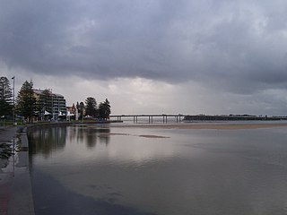
The Entrance Bridge is a road bridge that carries the Central Coast Highway (A49) across the Tuggerah Lakes Entrance Channel and joins the towns of The Entrance and The Entrance North, located on the Central Coast of New South Wales, Australia. The 18-span, 467-metre long (1,532 ft) concrete girder bridge carries road traffic, as well as a grade-separated pedestrian footpath and cycleway, across Wilfred Barrett Drive as part of the Central Coast Highway.

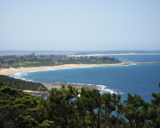
Shelly Beach is a coastal suburb of the Central Coast region of New South Wales, Australia, located east of Tuggerah Lake and bordering the Pacific Ocean south of The Entrance. It is part of the Central Coast Council local government area. It is 66 km south of Newcastle & 93 km north of Sydney. Shelly Beach is considered one of the most popular surfing beaches on the Central Coast.

Toowoon Bay is a suburb of the Central Coast region of New South Wales, Australia, located on a peninsula between Tuggerah Lake and the Pacific Ocean south of The Entrance. It is part of the Central Coast Council local government area.
Bouddi is a coastal south-eastern locality on the Central Coast of New South Wales, Australia. It is in the Central Coast Council local government area. Bouddi is the Aboriginal word for the heart.

Box Head is a coastal locality in the Central Coast Council local government area located on the Central Coast of New South Wales, Australia. It is within Bouddi National Park which includes the island of Lion Island.

Empire Bay is a suburb on the Central Coast of New South Wales, Australia. It is part of the Central Coast Council local government area.
Central Coast Highway is a 50-kilometre (31 mi) highway through the Central Coast region of New South Wales, Australia. It connects Pacific Motorway (M1) at Kariong with Pacific Highway (A43) at Doyalson. The highway was named after the region it goes through, to provide an easily identifiable route for visitors to the region, and is designated route A49.

The Entrance Tigers are a rugby league club based at The Entrance, New South Wales, Australia.They are competing in the 2022 Denton Engineering Cup & Central Coast Division Rugby League. They have previously competed in the Jim Beam Cup (2003-2007) and Ron Massey Cup (2010-2014). Their jersey is traditionally an all gold jersey with two black 'V's. In recent years they have included white in their jersey.

The Central Coast Council is a local government area in the Central Coast region of New South Wales, Australia. It is adjacent to the Pacific Highway, Central Coast Highway, the Northern railway line and the Pacific Ocean. The council was formed on 12 May 2016 following the merger of the Gosford City and Wyong Shire Councils.

