
The population of Australia is estimated to be 27,551,600 as of 8 December 2024. It is the 54th most populous country in the world and the most populous Oceanian country. Its population is concentrated mainly in urban areas, particularly on the Eastern, South Eastern and Southern seaboards, and is expected to exceed 30 million by 2029.
Noraville is a suburb of the Central Coast region of New South Wales, Australia. It is part of the Central Coast Council local government area. It is the site of Edward Hargraves' property that he purchased after his discovery of payable gold.

Allambie Heights is a suburb of Northern Sydney, in the state of New South Wales, Australia 17.5 kilometres north-east of the Sydney central business district in the local government area of Northern Beaches Council. It is part of the Northern Beaches region.
Yennora is a suburb of Sydney in the state of New South Wales, Australia, 29 kilometres west of the Sydney central business district. The residential part of the suburb is primarily in the local government area of the City of Fairfield, although the industrial area in west is a part of Cumberland Council. It is part of the Greater Western Sydney region.

The Shire of Ngaanyatjarraku is a remote local government area in Western Australia near the Northern Territory/South Australian border. It is 1,542 km (958 mi) from Perth.
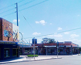
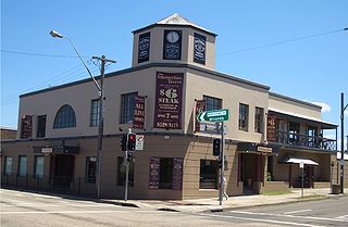
Toukley is a town in the Central Coast region of the Australian state of New South Wales and is located within Central Coast Council. It lies approximately 109 km north of Sydney and 54 km south of Newcastle via the Pacific Motorway (M1). It is located between Tuggerah Lake, Budgewoi Lake, and the Pacific Ocean. At the channel connecting Tuggerah Lake and Budgewoi Lake the new Toukley bridge was constructed between 1983 and 1985 linking Toukley on the eastern side of the Lakes system with Gorokan on the west, replacing the old two lane wooden bridge.
Ramsgate is a suburb in southern Sydney, in the state of New South Wales, Australia 16 km south of the Sydney central business district. It is part of the St George area. Divided by Rocky Point Road, part of Ramsgate to the east of Rocky Point Road is in the local government area of the Bayside Council, whilst properties to the west of Rocky Point Road are in the Georges River Council. Ramsgate Beach is a separate suburb, to the east.

Queenscliff is a suburb of northern Sydney, in the state of New South Wales, Australia. Queenscliff is located 16 kilometres north-east of the Sydney central business district, in the local government area of Northern Beaches Council and is part of the Northern Beaches region.

Bilgola Beach is a suburb in Sydney's Northern Beaches in the state of New South Wales, Australia. Bilgola Beach is 33 kilometres north-east of the Sydney central business district, in the local government area of Northern Beaches Council. It and Bilgola Plateau were gazetted as suburbs in 2012, dividing the previous suburb of Bilgola.

Wamberal is a coastal suburb of the Central Coast region of New South Wales, Australia, just north of Terrigal. It is part of the Central Coast Council local government area and is located adjacent to the Wamberal Lagoon. Wamberal is an Aboriginal word meaning 'where the sea breaks'.
Greenfield Park is a suburb of Sydney, in the state of New South Wales, Australia. Greenfield Park is located 36 kilometres west of the Sydney central business district in the local government area of the City of Fairfield. The suburb has one of the highest proportions of Assyrian people in the Sydney area and Australia per se.
Boolaroo is a suburb and former town of Greater Newcastle, city of Lake Macquarie, in New South Wales, Australia.

Henley Beach is a coastal suburb of Adelaide, South Australia in the City of Charles Sturt.

Underwood is a suburb in the City of Logan, Queensland, Australia. In the 2021 census, Underwood had a population of 6,809 people.

Budgewoi is a coastal town that is located on the Central Coast of New South Wales, Australia. Budgewoi is situated on two peninsulas that is split by the Budgewoi Lake. The town is located about 114 km northeast of Sydney. It is part of the Central Coast Council local government area.

Chittaway Bay is a suburb of the Central Coast region of New South Wales, Australia. It is part of the Central Coast Council local government area.

Killarney Vale is a suburb of the Central Coast region of New South Wales, Australia, located approximately 5 kilometres south of The Entrance. It is part of the Central Coast Council local government area.
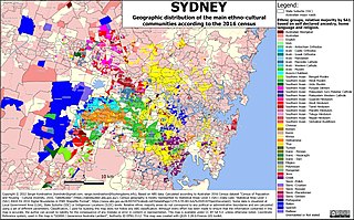
Sydney is Australia's most populous city, and is also the most populous city in Oceania. In the 2021 census, 5,231,147 persons declared themselves as residents of the Sydney Statistical Division–about one-fifth (20.58%) of Australia's total population. With a population density of 2037 people per square kilometre, the urban core has population density five times that of the greater region.

Brinkin is a northern suburb of Darwin, the capital city of the Northern Territory, Australia. It is located 12 kilometres (7 mi) north of Darwin's central business district, and is home to the Casuarina campus of Charles Darwin University. It is the traditional country and waterways of the Larrakia people.
Bellara is a suburb of Bribie Island in the City of Moreton Bay, Queensland, Australia. In the 2021 census, Bellara had a population of 3,278 people.


