
The Central Coast is a peri-urban region lying on the Pacific Ocean in northern-eastern New South Wales, Australia. The region is situated north of Sydney, which is filled with subtropical national parks, forests and also encompasses the major coastal waterways of Brisbane Water, Tuggerah Lakes and southern Lake Macquarie. The region's hinterland, which has fertile valleys, rural farmland and wineries, and also includes the Watagan Mountains. The Central Coast is known for its regional coastal towns like Terrigal, The Entrance, Ettalong Beach, Budgewoi and Bateau Bay with resorts and holiday parks, which feature many expansive beaches and lagoons with surfing and coastal tracks, as well as scenic views. Gosford is the main commercial hub and gateway.

Wamberal is a coastal suburb of the Central Coast region of New South Wales, Australia, just north of Terrigal. It is part of the Central Coast Council local government area and is located adjacent to the Wamberal Lagoon. Wamberal is an Aboriginal word meaning 'where the sea breaks'.

The M1 Pacific Motorway is a 127-kilometre motorway linking Sydney to Newcastle via the Central Coast and Hunter regions of New South Wales. Formerly known but still commonly referred to by both the public and the government as the F3 Freeway, Sydney–Newcastle Freeway, and Sydney–Newcastle Expressway, it is part of the AusLink road corridor between Sydney and Brisbane. The name "F3 Freeway" reflects its former route allocation before it was decommissioned and replaced by the rollout of alphanumeric signposts.

Tuggerah is a large commercial hub and a suburb of the Central Coast region of New South Wales, Australia. Tuggerah is situated on the Main North Railway Line and Pacific Motorway, and is located approximately 91 km north of Sydney and 68 km south of Newcastle. It is the second largest business hub, major shopping area and financial district for the Central Coast after Erina.
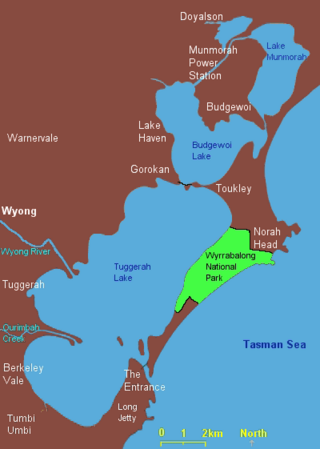
Lake Munmorah or Munmorah Lake, a lagoon that is part of the Tuggerah Lakes, is located within the Central Coast Council local government area in the Central Coast region of New South Wales, Australia. The lake is located near the settlement of Lake Munmorah and is situated about 110 kilometres (68 mi) north of Sydney.

Charmhaven is a suburb of the Central Coast region of New South Wales, Australia. It is part of the Central Coast Council local government area.
Colongra is a suburb of the Central Coast region of New South Wales, Australia, on the banks of Lake Munmorah. It is part of the Central Coast Council local government area.
Doyalson is a village of the Central Coast region of New South Wales, Australia. It is part of the Central Coast Council local government area and is adjacent to the Pacific Highway. It has a population of 313 at the 2016 census.

Booker Bay is a suburb of the Central Coast region of New South Wales Australia south-east of Woy Woy on Brisbane Water, about 80 kilometres (50 mi) north of Sydney. It is part of the Central Coast Council local government area.
Marlow is a suburb of the Central Coast region of New South Wales, Australia on the north bank of the Hawkesbury River 58 kilometres (36 mi) north of Sydney. It is part of the Central Coast Council local government area.

Mooney Mooney Creek is a suburb of the Central Coast region of New South Wales, Australia, located 60 kilometres (37 mi) north of Sydney along both sides of the river after which it is named. It is part of the Central Coast Council local government area.

North Avoca is a south-eastern suburb of the Central Coast region of New South Wales, Australia between Avoca Beach and Terrigal on the Tasman Sea coast. It is part of the Central Coast Council local government area.
North Gosford is a south-eastern suburb of the Central Coast region of New South Wales, Australia immediately north-east of Gosford's central business district. It is part of the Central Coast Council local government area.
Upper Mangrove is a suburb of the Central Coast region of New South Wales, Australia, located about 22 kilometres (14 mi) upstream and north of Spencer along Mangrove Creek. It is part of the Central Coast Council local government area.
Central Coast Highway is a 50-kilometre (31 mi) highway through the Central Coast region of New South Wales, Australia. It connects Pacific Motorway (M1) at Kariong with Pacific Highway (A43) at Doyalson. The highway was named after the region it goes through, to provide an easily identifiable route for visitors to the region, and is designated route A49.
The Central Coast Division of Country Rugby League is a rugby league competition based on the Central Coast of New South Wales between Sydney and Newcastle. The competition was founded in 1947 as a junior competition for the Newcastle club, Lakes United. The competition rapidly expanded and grew, so much so that in 1967, it was upgraded to full membership of the Country Rugby League as Group 12. In 1981, it was upgraded and renamed Central Coast Division. The division covers the entire region of the Central Coast from Woy Woy and Umina in the south up to Budgewoi and Gwandalan in the north.
Lower Mangrove is a suburb of the Central Coast region of New South Wales, Australia, located about 8 kilometres (5 mi) upstream and north of Spencer along Mangrove Creek. It is part of the Central Coast Council local government area.
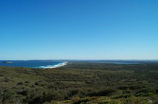
Munmorah State Conservation Area is located on the Central Coast of New South Wales, Australia. The area's coastal setting and panoramic views, perched sand dunes, diverse vegetation communities, protected threatened species and migratory bird habitats, together with opportunities for nature based recreation and for educational and scientific study, were cited as reasons for the reserve's creation. The reserve is part of the Tuggerah Important Bird Area, identified as such by BirdLife International because of its importance for a variety of water and woodland birds.
Blue Haven is a suburb on the Central Coast of New South Wales, Australia, located on Pacific Highway at Wallarah Creek. Its local government area is Central Coast Council.

