
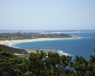
The Central Coast is a peri-urban region lying on the Pacific Ocean in northern-eastern New South Wales, Australia. The region is situated north of Sydney, which is filled with subtropical national parks, forests and also encompasses the major coastal waterways of Brisbane Water, Tuggerah Lakes and southern Lake Macquarie. The region's hinterland, which has fertile valleys, rural farmland and wineries, and also includes the Watagan Mountains. The Central Coast is known for its regional coastal towns like Terrigal, The Entrance, Ettalong Beach, Budgewoi and Bateau Bay with resorts and holiday parks, which feature many expansive beaches and lagoons with surfing and coastal tracks, as well as scenic views. Gosford is the main commercial hub and gateway.

Patterson Lakes is a suburb in Melbourne, Victoria, Australia, 35 km (22 mi) south-east of Melbourne's Central Business District, located within the City of Kingston local government area. Patterson Lakes recorded a population of 7,793 at the 2021 census.

The Mid North Coast is a country region in the north-east of the state of New South Wales, Australia. The region, situated 416km north of Sydney, covers the mid northern coast of the state, beginning from Port Stephens at Hawks Nest to as far north as Woolgoolga, near Coffs Harbour. The region has many beaches and subtropical national parks and forests as well as rural farmland and logging. Major coastal towns include Coffs Harbour, Forster and Port Macquarie. The Mid North Coast is a popular destination for camping or resorts and surfing, with coastal and hinterland tracks, with the unique heritage-listed mountain village of Bellbrook popular for day trips inland or 4wd campers and keen bass fishers.
Warners Bay is a suburb of the City of Lake Macquarie in New South Wales, Australia, and is located 15 kilometres (9 mi) from Newcastle's central business district on the eastern side of Lake Macquarie. It is often regarded as a part of the Greater Newcastle district. It was named after Jonathan Warner, who settled the area.

Belmont is a suburb in the City of Lake Macquarie New South Wales, Australia, located 20 kilometres (12 mi) from Newcastle's central business district on the eastern side of Lake Macquarie.

Ocean Reef is a suburb in northern Perth, Western Australia. It is located within the City of Joondalup. The name was coined by developers in the 1970s from the line of a reef visible several kilometres offshore. The name was formally adopted in 1974, replacing the prior name of Beaumaris, a name still retained by one of the shopping centres and one primary school.
Bateau Bay is a suburb of the Central Coast region of New South Wales, Australia. "Bateau" is French for "boat."

Safety Bay is an outer southern suburb of Perth, the capital city of Western Australia, located on the coast within the City of Rockingham.

Lennox Head is a seaside village in the Northern Rivers region of New South Wales, Australia, situated on the stretch of coast between Byron Bay and Ballina in Ballina Shire local government area. It had a population of 7,741 in the 2016 Australian census.

Morisset railway station is located on the Main Northern line in New South Wales, Australia. It serves the City of Lake Macquarie suburb of Morisset opening on 15 August 1887 as Morrisset being renamed on 1 February 1889.

RAAF Base Rathmines is a heritage-listed former RAAF Second World War seaplane base and now used as community venues, sports venues and a visitor attraction at Dorrington Road, Rathmines, City of Lake Macquarie, New South Wales, Australia. It was in use as an RAAF base from 1939 to 1961. It is also known as Rathmines Park, former RAAF Seaplane Base, Flying Boat Base, Rathmines Aerodrome and Catalina Base. The property is owned by Australian Christadelphian Bible School, Disability Life Enrichment, Don Geddes Nursing Home and Lake Macquarie City Council. The remains of the former air base was added to the New South Wales State Heritage Register on 25 November 2005.
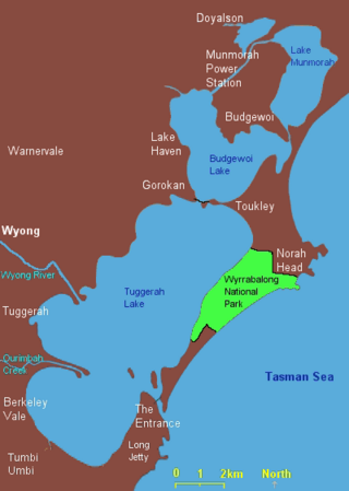
Lake Munmorah or Munmorah Lake, a lagoon that is part of the Tuggerah Lakes, is located within the Central Coast Council local government area in the Central Coast region of New South Wales, Australia. The lake is located near the settlement of Lake Munmorah and is situated about 110 kilometres (68 mi) north of Sydney.

Lake Macquarie is Australia's largest coastal lagoon. Located in the City of Lake Macquarie and Central Coast Council local government areas in the Hunter and Central Coast regions of New South Wales, Australia, it covers an area of 110 square kilometres (42.5 sq mi) and is connected to the Tasman Sea by a short channel. Most of the residents of the City of Lake Macquarie live near the shores of the lagoon.

Tourism in Sydney forms an important part of the city's economy. The city received 12 million domestic visitors and 4.1 million international visitors in year ending June 2019. The most famous attractions include the Sydney Opera House, and the Sydney Harbour Bridge. Other attractions include the Sydney Mardi Gras, Royal Botanical Gardens, Luna Park, the beaches and Sydney Tower.

Charmhaven is a suburb of the Central Coast region of New South Wales, Australia. It is part of the Central Coast Council local government area.
Gwandalan is a suburb of the Central Coast region of New South Wales, Australia, located on a peninsula extending northwards into Lake Macquarie. It is part of the Central Coast Council local government area.

Potato Point is a village in the Eurobodalla Shire lying on the south coast of New South Wales, Australia. It is connected by road to the town of Bodalla, and surrounded by the Eurobodalla National Park. The Yuin are considered to be the traditional owners of the region. At the 2016 census, Potato Point had a population of 135 and 56 occupied and 78 unoccupied dwellings. The only non-residential facilities are the local rural fire brigade depot which houses two appliances, toilet and shower block, boat ramp, two small parks and a telephone box.
Bathurst Harbour is a shallow bay located in the south west region of Tasmania, Australia. Bathurst Harbour is contained within the Port Davey/Bathurst Harbour Marine Nature Reserve, and the Southwest National Park, part of the Tasmanian Wilderness World Heritage Area.

The Man O'War Steps is a heritage-listed jetty located at Farm Cove Crescent, in the Sydney central business district, in the City of Sydney local government area of New South Wales, Australia. It was built from 1810. The property is owned by Transport for NSW. It was added to the New South Wales State Heritage Register on 18 April 2000. The Steps are located on the eastern bank of Bennelong Point, adjacent to the Sydney Opera House and on the north-western boundary of the Royal Botanic Garden.

