
Warnervale is a town in the Central Coast Council local government area in the Central Coast region in the state of New South Wales, Australia. It lies approximately 101 km north of Sydney, located west of Tuggerah Lake, a large shallow coastal lake, and just north of Wyong.

Budgewoi is a coastal town that is located on the Central Coast of New South Wales, Australia. Budgewoi is situated on two peninsulas that is split by the Budgewoi Lake. The town is located about 114 km northeast of Sydney. It is part of the Central Coast Council local government area.
Buff Point is a suburb of the Central Coast region of New South Wales, Australia. It is part of the Central Coast Council local government area.
Colongra is a suburb of the Central Coast region of New South Wales, Australia, on the banks of Lake Munmorah. It is part of the Central Coast Council local government area.
Palmdale is a suburb of the Central Coast region of New South Wales, Australia. It is part of the Central Coast Council local government area.
San Remo is a suburb of the Central Coast region of New South Wales, Australia. It is part of the Central Coast Council local government area and is home to Northlakes High School, which has over 1000 students, and the San Remo Neighbourhood Centre.

Wyong Creek is a suburb of the Central Coast region of New South Wales, Australia. It is part of the Central Coast Council local government area.
Marlow is a suburb of the Central Coast region of New South Wales, Australia on the north bank of the Hawkesbury River 58 kilometres (36 mi) north of Sydney. It is part of the Central Coast Council local government area.
Upper Mangrove is a suburb of the Central Coast region of New South Wales, Australia, located about 22 kilometres (14 mi) upstream and north of Spencer along Mangrove Creek. It is part of the Central Coast Council local government area.
Budgewoi Peninsula is a coastal suburb of the Central Coast region of New South Wales, Australia, on a narrow peninsula between Munmorah Lake and the Pacific Ocean. It is part of the Central Coast Council local government area.

The Mooney Mooney Bridge, officially the Mooney Mooney Creek Bridge, and popularly known as The NSW Big Dipper Bridge, is a twin cantilever bridge that carries the Pacific Motorway (M1) across Mooney Mooney Creek, located near Mooney Mooney in the Brisbane Water National Park on the Central Coast of New South Wales, Australia. The concrete box girder bridge was opened on 14 December 1986 by the Prime Minister of Australia, Bob Hawke, and is owned and maintained by Transport for NSW, an agency of the Government of New South Wales.
The Wallarah 2 Coal Project is a proposal by the Korea Resources Corporation or KORES to construct a longwall mine near Wyong, New South Wales, Australia. The underground mine is now being considered by the NSW Department of Planning. It was previously rejected by the Keneally Government shortly before the 2011 State election.
Lower Mangrove is a suburb of the Central Coast region of New South Wales, Australia, located about 8 kilometres (5 mi) upstream and north of Spencer along Mangrove Creek. It is part of the Central Coast Council local government area.
Durren Durren is a suburb of the Central Coast region of New South Wales, Australia. It is part of the Central Coast Council local government area.
Palm Grove is a suburb of the Central Coast region of New South Wales, Australia. It is located about 10 kilometres (6 mi) upstream along Ourimbah Creek from the town of Ourimbah. It is part of the Central Coast Council local government area.
Halloran is a sparsely populated suburb of the Central Coast region of New South Wales, Australia, located off the Sydney-Newcastle Freeway between Wyong and Morisset. It is part of the Central Coast Council local government area.
Crangan Bay is a coastal suburb of the Central Coast region of New South Wales, Australia, located between Budgewoi and Swansea on the bay of the same name. It is part of the Central Coast Council local government area.
Moonee is a coastal suburb of the Central Coast region of New South Wales, Australia. It is part of the Central Coast Council local government area.
Blue Haven is a suburb on the Central Coast of New South Wales, Australia, located on Pacific Highway at Wallarah Creek. Its local government area is Central Coast Council.
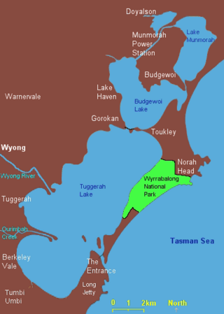
The Budgewoi Lake is a lagoon that is part of the Tuggerah Lakes, that is located within the Central Coast Council local government area in the Central Coast region of New South Wales, Australia. The lake is located near the settlement of Budgewoi and is situated about 100 kilometres (62 mi) north of Sydney.

