
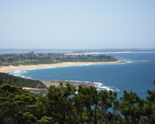
The Central Coast is a peri-urban region lying on the Pacific Ocean in northern-eastern New South Wales, Australia. The region is situated north of Sydney, which is filled with subtropical national parks, forests and also encompasses the major coastal waterways of Brisbane Water, Tuggerah Lakes and southern Lake Macquarie. The region's hinterland, which has fertile valleys, rural farmland and wineries, and also includes the Watagan Mountains. The Central Coast is known for its regional coastal towns like Terrigal, The Entrance, Ettalong Beach, Budgewoi and Bateau Bay with resorts and holiday parks, which feature many expansive beaches and lagoons with surfing and coastal tracks, as well as scenic views. Gosford is the main commercial hub and gateway.

Wyong is a town on the Central Coast of New South Wales, Australia. It is located approximately 63 km SSW of Newcastle and 93 km NNE of the state capital Sydney. Established in 1888, it is one of the two administrative centres for the Central Coast Council local government area.

Erina is a suburb located in the Central Coast region of New South Wales, Australia. Erina is the largest commercial hub of the Central Coast and is home to the largest single level shopping centre in the Southern Hemisphere that is called Erina Fair. It is part of the Central Coast Council local government area.
Bateau Bay is a suburb of the Central Coast region of New South Wales, Australia. "Bateau" is French for "boat."

Berkeley Vale is a suburb of the Central Coast region of New South Wales, Australia. Berkeley Vale is commuting distance from Sydney. It is part of the Central Coast Council local government area and part of the federal division of Dobell.
Alison is a semi-rural suburb of the Central Coast region of New South Wales, Australia, located on the north bank of the Wyong River 4 kilometres (2.5 mi) northwest of the regional centre of Wyong. It is part of the Central Coast Council local government area.

Chittaway Bay is a suburb of the Central Coast region of New South Wales, Australia. It is part of the Central Coast Council local government area.
Jilliby is a large rural locality with farms and bush land that is located in the Dooralong Valley of the Central Coast region of New South Wales, Australia. It is part of the Central Coast Council local government area.

Killarney Vale is a suburb of the Central Coast region of New South Wales, Australia, located approximately 5 kilometres south of The Entrance. It is part of the Central Coast Council local government area.

Lake Munmorah is a suburb of the Central Coast region of New South Wales, Australia. It is part of the Central Coast Council local government area.
Bensville is a suburb of the Central Coast region of New South Wales, Australia. It is part of the Central Coast Council local government area.
Central Mangrove is a locality within the Central Coast region of New South Wales, Australia. It is about 81 kilometres (50 mi) north of Sydney. The locality is located within the Central Coast Council local government area.
Little Wobby is a suburb of the Central Coast region of New South Wales, Australia, located on the north bank of the Hawkesbury River. It is part of the Central Coast Council local government area.
Peats Ridge is a suburb in the Central Coast region of New South Wales, Australia, as part of the Central Coast Council local government area.

West Gosford is a suburb of the Central Coast region of New South Wales, Australia. It is part of the Central Coast Council local government area. West Gosford is home to the Henry Kendall cottage and was home to the Gosford Classic Car Museum prior to its 2019 closure. While there are some residential areas, West Gosford is known as a retail and industry hub. Bunnings, Spotlight, Anaconda and Officeworks join the Gosford RSL and a Reliance Super Clinic along the Central Coast Highway.
Crangan Bay is a coastal suburb of the Central Coast region of New South Wales, Australia, located between Budgewoi and Swansea on the bay of the same name. It is part of the Central Coast Council local government area.
Blue Haven is a suburb on the Central Coast of New South Wales, Australia, located on Pacific Highway at Wallarah Creek. Its local government area is Central Coast Council.

Clagiraba is a rural locality in the City of Gold Coast, Queensland, Australia. In the 2021 census, Clagiraba had a population of 651 people.

Little Mountain is a suburb of Caloundra in the Sunshine Coast Region, Queensland, Australia. In the 2016 census, Little Mountain had a population of 10,212 people.

