Gosford is a waterfront city at the northern end of Brisbane Water on the Central Coast in the state of New South Wales, Australia. The Gosford waterfront is known for its boating and scenic views on the shores of Brisbane Water. Gosford is the main commercial hub and gateway of the Central Coast. It is situated approximately 77 km (48 mi) north of Sydney and 86 km (53 mi) south of Newcastle. Gosford is located in the local government area of the Central Coast Council.

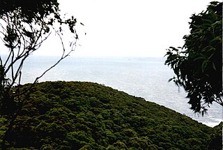
The Bouddi National Park is a coastal national park that is located in the Central Coast region of New South Wales, in eastern Australia. The 1,532-hectare (3,790-acre) national park is situated 93 kilometres (58 mi) northeast of Sydney. A section of the national park extends into the Tasman Sea, creating fully protected land, shore and marine habitats. The park contains one of the last mature temperate rainforests on the Central Coast, Fletchers Glen.
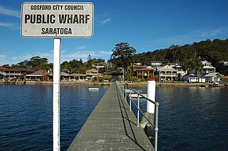
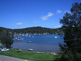
Saratoga is a residential south-eastern village and suburb of the Central Coast region of New South Wales, Australia, located on a peninsula of Brisbane Water and part of the Central Coast Council local government area. The suburb is characterised by its largely settled shoreline, with houses extending up coastal slopes to the base of the tall hills that comprise the core of the peninsula.

Kincumber is a south-eastern suburb of the Central Coast region of New South Wales, Australia, nested between the Kincumba Mountain Reserve and the Kincumber Broadwater and located 87 kilometres (54 mi) north of Sydney via the Sydney-Newcastle Freeway (F3). It is part of the Central Coast Council local government area. It is on The Guringgai land
Umina Beach is a suburb within the Central Coast Council local government area on the Central Coast of New South Wales, Australia. Umina Beach is situated 85 kilometres (53 mi) north of Sydney and 111 kilometres (69 mi) south of Newcastle.

Toowoon Bay is a suburb of the Central Coast region of New South Wales, Australia, located on a peninsula between Tuggerah Lake and the Pacific Ocean south of The Entrance. It is part of the Central Coast Council local government area.
Bouddi is a coastal south-eastern locality on the Central Coast of New South Wales, Australia. It is in the Central Coast Council local government area. Bouddi is the Aboriginal word for the heart.

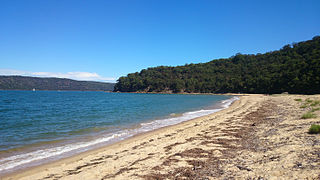
Box Head is a coastal locality in the Central Coast Council local government area located on the Central Coast of New South Wales, Australia. It is within Bouddi National Park which includes the island of Lion Island.

Hardys Bay is a south-eastern suburb of the Central Coast region of New South Wales, Australia on the Bouddi Peninsula. It is part of the Central Coast Council local government area.
Killcare is a south-eastern suburb and village located on the Bouddi Peninsula on the Central Coast of the state of New South Wales, Australia. It is part of the Central Coast Council local government area.

Killcare Heights is a south-eastern suburb and village located on the Bouddi Peninsula of the Central Coast region of New South Wales, Australia. It is part of the Central Coast Council local government area.

Koolewong is a suburb of the Central Coast region of New South Wales, Australia between Gosford and Woy Woy, and is mostly on a hill overlooking Brisbane Water. It is part of the Central Coast Council local government area.
Little Wobby is a suburb of the Central Coast region of New South Wales, Australia, located on the north bank of the Hawkesbury River. It is part of the Central Coast Council local government area.

MacMasters Beach is a south-eastern suburb of the Central Coast region of New South Wales, Australia on the Bouddi Peninsula. It is part of the Central Coast Council local government area

Mooney Mooney is a small waterfront village and suburb of the Central Coast region of New South Wales, Australia. It is located in the Central Coast Council local government area at the end of a peninsula extending southwards into the Hawkesbury River, that is situated 50 kilometres (31 mi) north of Sydney. Mooney Mooney has two islands which are Peat Island and Spectacle Island.
Patonga is a small beach side fishing and holiday village which is part of the Central Coast region of New South Wales, Australia, located on the edge of Brisk Bay and near the mouth of the Hawkesbury River. It is part of the Central Coast Council local government area. Patonga is the southern most village of the Central Coast.
Point Clare is a suburb of the Central Coast region of New South Wales, Australia located approximately 75 kilometres (47 mi) north of Sydney and 4 kilometres (2 mi) south-west of Gosford's central business district on the western shore of Brisbane Water. It is part of the Central Coast Council local government area.

Point Frederick is a suburb of the Central Coast region of New South Wales, Australia on a peninsula protruding into Brisbane Water 2 kilometres (1 mi) south-southeast of Gosford's central business district. It is part of the Central Coast Council local government area.

Wagstaffe is a south-eastern suburb of the Central Coast region of New South Wales, Australia on the Bouddi Peninsula. It is part of the Central Coast Council local government area. It was named after Captain Wagstaffe, one of the first settlers in the area. It has a general store, which is also the local post office. It is a thin slither of around 200 houses between the bay and the bush. Historically it was also known as Wagstaffe Point. In aboriginal dialect the point is called Kourang Gourang. A ferry service operates between Wagstaffe and Palm Beach. Travel time is 30 minutes.
Turkey Beach is a coastal town and locality in the Gladstone Region, Queensland, Australia. In the 2021 census, the locality of Turkey Beach had a population of 148 people.