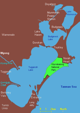
Lake Munmorah or Munmorah Lake, a lagoon that is part of the Tuggerah Lakes, is located within the Central Coast Council local government area in the Central Coast region of New South Wales, Australia. The lake is located near the settlement of Lake Munmorah and is situated about 110 kilometres (68 mi) north of Sydney.

Gorokan is a suburb of the Central Coast region of New South Wales, Australia. Gorokan faces towards the Tuggerah Lake and the Budgewoi Lake on the western shores. It is part of the Central Coast Council local government area.
Port Hughes is a town and locality in the Australian state of South Australia located on northern Yorke Peninsula about 135 kilometres (84 mi) north-west of the state capital of Adelaide. It is considered part of the Moonta urban area by the Australian Bureau of Statistics. At the 2016 census, Port Hughes had a population of 571.
The Tuggerah Lakes, a wetland system of three interconnected coastal lagoons, are located on the Central Coast of New South Wales, Australia and comprise Lake Munmorah, Budgewoi Lake and Tuggerah Lake.

Budgewoi is a coastal town that is located on the Central Coast of New South Wales, Australia. Budgewoi is situated on two peninsulas that is split by the Budgewoi Lake. The town is located about 114 km northeast of Sydney. It is part of the Central Coast Council local government area.

Charmhaven is a suburb of the Central Coast region of New South Wales, Australia. It is part of the Central Coast Council local government area.
Colongra is a suburb of the Central Coast region of New South Wales, Australia, on the banks of Lake Munmorah. It is part of the Central Coast Council local government area.
Doyalson is a village of the Central Coast region of New South Wales, Australia. It is part of the Central Coast Council local government area and is adjacent to the Pacific Highway. It has a population of 313 at the 2016 census.
Gwandalan is a suburb of the Central Coast region of New South Wales, Australia, located on a peninsula extending northwards into Lake Macquarie. It is part of the Central Coast Council local government area.
Hamlyn Terrace is a suburb of the Central Coast region of New South Wales, Australia. It is part of the Central Coast Council local government area. The suburb was formerly part of Warnervale and is part of the Warnervale development precinct. The suburb is split between two governmental wards in the Central Coast Council governmental area, the northern part is in the Budgewoi ward and the rest is in the Wyong ward.

Lake Munmorah is a suburb of the Central Coast region of New South Wales, Australia. It is part of the Central Coast Council local government area.
Summerland Point is a waterfront suburb that is located on the Central Coast of New South Wales, Australia. Summerland Point is situated on a peninsula extending northwards and facing towards Lake Macquarie. It is part of the Central Coast Council local government area. It was formerly known as Gwandalan West.

Box Head is a coastal locality in the Central Coast Council local government area located on the Central Coast of New South Wales, Australia. It is within Bouddi National Park which includes the island of Lion Island.
Upper Mangrove is a suburb of the Central Coast region of New South Wales, Australia, located about 22 kilometres (14 mi) upstream and north of Spencer along Mangrove Creek. It is part of the Central Coast Council local government area.

The Shire of Shark Bay is a local government area of Western Australia in the Gascoyne region. It has an area of 25,423 km2 and a population of about 950. It is made up of two peninsulas and Shark Bay, located at the westernmost point of Australia. There is one town in the Shire of Shark Bay, Denham, which is the administrative centre for the Shire. There are also a number of small communities; they are Useless Loop, Monkey Mia, Nanga and Hamelin Pool. The Overlander and The Billabong are roadhouses.
Crangan Bay is a coastal suburb of the Central Coast region of New South Wales, Australia, located between Budgewoi and Swansea on the bay of the same name. It is part of the Central Coast Council local government area.
Moonee is a coastal suburb of the Central Coast region of New South Wales, Australia. It is part of the Central Coast Council local government area.
The Budgewoi Lake is a lagoon that is part of the Tuggerah Lakes, that is located within the Central Coast Council local government area in the Central Coast region of New South Wales, Australia. The lake is located near the settlement of Budgewoi and is situated about 100 kilometres (62 mi) north of Sydney.
Hayborough is a north-eastern suburb of the South Australian town of Victor Harbor, located on the south coast of Fleurieu Peninsula.

