
The City of Wanneroo is a local government area with city status in the northern suburbs of Perth, Western Australia. It is centred approximately 25 kilometres (15.5 mi) north of Perth's central business district and forms part of the northern boundary of the Perth metropolitan area. Wangara encompasses the federal divisions of Cowan, Moore and Pearce.

The Shire of Yilgarn is a local government area in the eastern Wheatbelt region of Western Australia about 400 kilometres (250 mi) east of Perth, the state capital. The Shire covers an area of 30,720 square kilometres (11,860 sq mi) and its seat of government is the town of Southern Cross. The main industries within the Shire are mining and farming.

The Shire of Wyndham East Kimberley is one of the four local government areas in the Kimberley region of northern Western Australia, covering an area of 117,514 square kilometres (45,372 sq mi) at Western Australia's northeastern corner. The Shire's seat of government was originally in Wyndham but now in the town of Kununurra, which is home to over half of the Shire's permanent population of around 7,000, while a council office is located at Wyndham.

The Shire of Mount Marshall is a local government area in the Wheatbelt region of Western Australia, about 80 kilometres (50 mi) north-northwest of Merredin and about 300 kilometres (186 mi) northeast of the state capital, Perth. The Shire covers an area of 10,190 square kilometres (3,934 sq mi), and its seat of government is the town of Bencubbin.
Gwandalan is a suburb of the Central Coast region of New South Wales, Australia, located on a peninsula extending northwards into Lake Macquarie. It is part of the Central Coast Council local government area.

Lake Munmorah is a suburb of the Central Coast region of New South Wales, Australia. It is part of the Central Coast Council local government area.
Budgewoi Peninsula is a coastal suburb of the Central Coast region of New South Wales, Australia, on a narrow peninsula between Munmorah Lake and the Pacific Ocean. It is part of the Central Coast Council local government area.

The City of Mandurah is a local government area of Western Australia, covering both Mandurah proper and an additional area reaching down as far south as Lake Clifton. The city has a total area of approximately 174 square kilometres (67 sq mi).

The Shire of Murray is a local government area of Western Australia. It has an area of 1,710.1 square kilometres (660.3 sq mi) and is located in the Peel Region about 80 kilometres (50 mi) south of the Perth central business district.

The Shire of Lake Grace is a local government area in the eastern Wheatbelt region of Western Australia, about 350 kilometres (217 mi) ESE of the state capital, Perth. The Shire has a land area of 10,379 square kilometres (4,007 sq mi) and its seat of government is the town of Lake Grace.
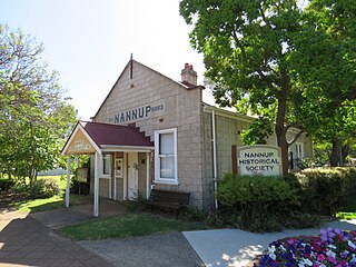
The Shire of Nannup is a local government area in the South West region of Western Australia, approximately 280 kilometres (174 mi) south of the state capital, Perth and 60 kilometres (37 mi) southeast of the coastal resort town of Busselton. Its seat of government is the town of Nannup, where about half of the Shire's population reside.

The Shire of Mundaring is a local government area in eastern metropolitan Perth, the capital of Western Australia. The Shire covers an area of 645 square kilometres (249 sq mi) and had a population of approximately 38,000 as at the 2016 Census.

The City of Armadale is a local government area in the southeastern suburbs of the Western Australian capital city of Perth, about 28 kilometres (17.4 mi) southeast of Perth's central business district. The City covers an area of 560 square kilometres (216 sq mi), much of which is state forest rising into the Darling Scarp to the east, and had a population of almost 80,000 as at the 2016 Census.

The Shire of Collie is a local government area in the South West region of Western Australia, about 60 kilometres (37 mi) east of Bunbury and about 200 kilometres (124 mi) south of the state capital, Perth. The Shire covers an area of 1,711 square kilometres (661 sq mi), and its seat of government is the town of Collie.
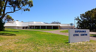
The Shire of Esperance is a local government area in the Goldfields-Esperance region of Western Australia, about 400 kilometres (250 mi) south of the town of Kalgoorlie and about 720 kilometres (450 mi) east-southeast of the state capital, Perth. The Shire covers an area of 42,547 square kilometres (16,427 sq mi), and its seat of government is the town of Esperance, where about three-quarters of the Shire's population resides.
Moonee is a coastal suburb of the Central Coast region of New South Wales, Australia. It is part of the Central Coast Council local government area.

Eungella Dam is a locality in the Mackay Region, Queensland, Australia. IIn the 2021 census, Eungella Dam had a population of 4 people.

Leslie Dam is a locality in the Southern Downs Region, Queensland, Australia. In the 2021 census, Leslie Dam had a population of 118 people.
Westvale is a locality in the Somerset Region, Queensland, Australia. In the 2021 census, Westvale had a population of 0 people.


