The Central Coast is a peri-urban region lying on the Pacific Ocean in northern-eastern New South Wales, Australia. The region is situated north of Sydney, which is filled with subtropical national parks, forests and also encompasses the major coastal waterways of Brisbane Water, Tuggerah Lakes and southern Lake Macquarie. The region's hinterland, which has fertile valleys, rural farmland and wineries, and also includes the Watagan Mountains. The Central Coast is known for its regional coastal towns like Terrigal, The Entrance, Ettalong Beach, Budgewoi and Bateau Bay with resorts and holiday parks, which feature many expansive beaches and lagoons with surfing and coastal tracks, as well as scenic views. Gosford is the main commercial hub and gateway.

Deer Park is a suburb in Melbourne, Victoria, Australia, 17 km (11 mi) west of the Melbourne central business district, located within the City of Brimbank local government area. Deer Park recorded a population of 18,145 at the 2021 census.

Patterson Lakes is a suburb in Melbourne, Victoria, Australia, 35 km (22 mi) south-east of Melbourne's Central Business District, located within the City of Kingston local government area. Patterson Lakes recorded a population of 7,793 at the 2021 census.

Cairnlea is a suburb in Melbourne, Victoria, Australia, 17 km (11 mi) north-west of Melbourne's central business district, located within the City of Brimbank local government area. Cairnlea recorded a population of 10,038 at the 2021 census.
Mill Park is a suburb of Melbourne, Victoria, Australia, 18 km north-east of Melbourne's central business district, located within the City of Whittlesea local government area. Mill Park recorded a population of 28,712 at the 2021 census.

Warnervale is a town in the Central Coast Council local government area in the Central Coast region in the state of New South Wales, Australia. It lies approximately 101 km north of Sydney, located west of Tuggerah Lake, a large shallow coastal lake, and just north of Wyong.

Erina is a suburb located in the Central Coast region of New South Wales, Australia. Erina is the largest commercial hub of the Central Coast and is home to the largest single level shopping centre in the Southern Hemisphere that is called Erina Fair. It is part of the Central Coast Council local government area.

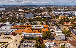
Joondalup is a suburb of Perth, Western Australia, approximately 26 kilometres (16 mi) north of Perth's central business district. It contains the central business district of the regional City of Joondalup and acts as the primary urban centre of Perth's outer northern suburbs.

Melbourne is Australia's second largest city and widely considered to be a garden city, with Victoria being nicknamed "the Garden State". Renowned as one of the most livable cities in the world, there is an abundance of parks, gardens and green belts close to the CBD with a variety of common and rare plant species amid landscaped vistas, pedestrian pathways, and tree-lined avenues, all managed by Parks Victoria.

East Ryde is a suburb of Sydney in the state of New South Wales, Australia. East Ryde is in the Northern Sydney region and is located 12 kilometers north-west of the Sydney central business district, in the local government area of the City of Ryde. East Ryde sits on the western bank of the Lane Cove River. East Ryde shares the postcode of 2113 with the adjacent suburb of North Ryde, though it does not have a post office of its own.

Winthrop is a southern suburb of Perth, Western Australia, located within the City of Melville.

Atwell is a suburb within the metropolitan area of Perth, Western Australia, situated 21 kilometres (13 mi) south of Perth City, and located in the City of Cockburn local government area.

Beeliar is a suburb of Perth, Western Australia, located within the City of Cockburn. The name refers to the Beeliar people, a group of Aboriginal Australians who had land rights over the southern half of Perth's metropolitan area. The suburb contains the Thomsons Lake Nature Reserve.

M1 Pacific Motorway is a 127-kilometre motorway linking Sydney to Newcastle via the Central Coast and Hunter regions of New South Wales. Formerly known but still commonly referred to by both the public and the government as the F3 Freeway, Sydney–Newcastle Freeway, and Sydney–Newcastle Expressway, it is part of the AusLink road corridor between Sydney and Brisbane.

Albanvale is a suburb in Melbourne, Victoria, Australia, 18 km (11 mi) north-west of Melbourne's central business district, located within the City of Brimbank local government area. Albanvale recorded a population of 5,641 at the 2021 census.
Gladstone Park is a suburb in Melbourne, Victoria, Australia, 15 km (9.3 mi) north-west of Melbourne's Central Business District, located within the City of Hume local government area. Gladstone Park recorded a population of 8,213 at the 2021 census.

Charmhaven is a suburb of the Central Coast region of New South Wales, Australia. It is part of the Central Coast Council local government area.

The Mooney Mooney Bridge, officially the Mooney Mooney Creek Bridge, and popularly known as The NSW Big Dipper Bridge, is a twin cantilever bridge that carries the Pacific Motorway (M1) across Mooney Mooney Creek, located near Mooney Mooney in the Brisbane Water National Park on the Central Coast of New South Wales, Australia. The concrete box girder bridge was opened on 14 December 1986 by the Prime Minister of Australia, Bob Hawke, and is owned and maintained by Transport for NSW, an agency of the Government of New South Wales.

Dalyston is a seaside town located 125 kilometres (78 mi) south east of Melbourne via the South Gippsland and Bass Highways, in the Bass Coast Shire of Gippsland, Victoria, Australia. Known originally as a train station at Powlett River near Wonthaggi, it is now the location of the Victorian Desalination Plant, and at the 2011 census, it had a population of 606. It's Bass Coast’s fastest-growing suburb, with the 2011 census showing Dalyston’s population more than doubled from 278 residents in 2006 to 606 in 2011.


