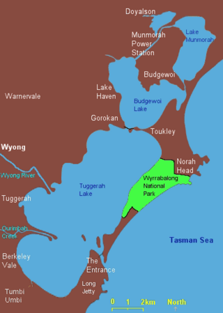
The Wyrrabalong National Park is a coastal national park that is located on the Central Coast of New South Wales, in eastern Australia. The 620-hectare (1,500-acre) national park consists of two sections; the northern section consists of approximately 480 hectares and covers a substantial area of the peninsula between The Entrance and Norah Head as well as Terilbah and Pelican Islands within Tuggerah Lake. The southern section consists of about 120 hectares of the coast, from Shelly Beach south to Forresters Beach. The park is also noted for containing the last significant coastal (littoral) rainforest on the Central Coast.

The Georges River, also known as Tucoerah River, is an intermediate tide-dominated drowned valley estuary, that is located in Sydney in the state of New South Wales, Australia. The Georges River is located south and south-west from the Sydney CBD, with the mouth of the river being at Botany Bay.

The Central Coast is a peri-urban region lying on the Pacific Ocean in northern-eastern New South Wales, Australia. The region is situated north of Sydney, which is filled with subtropical national parks, forests and also encompasses the major coastal waterways of Brisbane Water, Tuggerah Lakes and southern Lake Macquarie. The region's hinterland, which has fertile valleys, rural farmland and wineries, and also includes the Watagan Mountains. The Central Coast is known for its regional coastal towns like Terrigal, The Entrance, Ettalong Beach, Budgewoi and Bateau Bay with resorts and holiday parks, which feature many expansive beaches and lagoons with surfing and coastal tracks, as well as scenic views. Gosford is the main commercial hub and gateway.

Tuggerah Lake, an intermittently open intermediate wave dominated barrier estuary that is part of the Tuggerah Lakes, is located within the Central Coast Council local government area in the Central Coast region of New South Wales, Australia. The lake is located near Wyong and is situated about 90 kilometres (56 mi) north of Sydney.

Wyong Shire was a local government area located in the Central Coast region of New South Wales, Australia. The incorporation of the Wyong area dates back to 7 March 1906 when the entire area of the Brisbane Water Police District outside of the Town of Gosford was proclaimed as the Erina Shire. From 1 January 1947, local government in the Central Coast region was reorganised, creating Gosford Shire and Wyong Shire, which comprised Erina Shire north and east of Kulnura, Central Mangrove and Lisarow.
Toukley is a town in the Central Coast region of the Australian state of New South Wales and is located within Central Coast Council. It lies approximately 109 km north of Sydney and 54 km south of Newcastle via the Pacific Motorway (M1). It is located between Tuggerah Lake, Budgewoi Lake, and the Pacific Ocean. At the channel connecting Tuggerah Lake and Budgewoi Lake the new Toukley bridge was constructed between 1983 and 1985 linking Toukley on the eastern side of the Lakes system with Gorokan on the west, replacing the old two lane wooden bridge.

The Watagan Mountains or Watagans or Wattagan Mountains, is a mountain range which is part of the Great Dividing Range that’s located in the hinterlands of the Hunter and Central Coast regions of New South Wales, Australia. The range is situated between the Upper Hunter River catchment and the Tuggerah Lakes with close proximity to Lake Macquarie. The Watagans are a popular tourist location and are close to regional centres like Newcastle and Gosford.
Lake Munmorah or Munmorah Lake, a lagoon that is part of the Tuggerah Lakes, is located within the Central Coast Council local government area in the Central Coast region of New South Wales, Australia. The lake is located near the settlement of Lake Munmorah and is situated about 110 kilometres (68 mi) north of Sydney.

Lake Macquarie is Australia's largest coastal lagoon. Located in the City of Lake Macquarie and Central Coast Council local government areas in the Hunter and Central Coast regions of New South Wales, Australia, it covers an area of 110 square kilometres (42.5 sq mi) and is connected to the Tasman Sea by a short channel. Most of the residents of the City of Lake Macquarie live near the shores of the lagoon.

Gorokan is a suburb of the Central Coast region of New South Wales, Australia. Gorokan faces towards the Tuggerah Lake and the Budgewoi Lake on the western shores. It is part of the Central Coast Council local government area.
The Tuggerah Lakes, a wetland system of three interconnected coastal lagoons, are located on the Central Coast of New South Wales, Australia and comprise Lake Munmorah, Budgewoi Lake and Tuggerah Lake.

Budgewoi is a coastal town that is located on the Central Coast of New South Wales, Australia. Budgewoi is situated on two peninsulas that is split by the Budgewoi Lake. The town is located about 114 km northeast of Sydney. It is part of the Central Coast Council local government area.
Central Coast Highway is a 50-kilometre (31 mi) highway through the Central Coast region of New South Wales, Australia. It connects Pacific Motorway (M1) at Kariong with Pacific Highway (A43) at Doyalson. The highway was named after the region it goes through, to provide an easily identifiable route for visitors to the region, and is designated route A49.
Dora creek is a watercourse that is located in Greater Newcastle in the Hunter region of New South Wales, Australia.

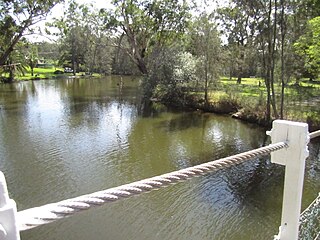
The Wyong River is a perennial river that is located in the Central Coast region of New South Wales, Australia.

Wallis Lake, an open and trained wave dominated barrier estuary, is located within the Mid-Coast Council local government area in the Mid North Coast region of New South Wales, Australia. Wallis Lake is located adjacent to the towns of Forster and Tuncurry, and adjacent to the east coast, about 308 kilometres (191 mi) north of Sydney.
Smiths Lake, an intermittently closed youthful saline coastal lagoon, is located within the Mid-Coast Council local government area in the Mid North Coast region of New South Wales, Australia. Smiths Lake is located adjacent to the village of Smiths Lake, and adjacent to the east coast, about 274 kilometres (170 mi) north of Sydney.

The Avoca Lake, formerly known as Avoca Lagoon and as Bulbararing Lagoon, is an intermittently closed intermediate saline coastal lagoon that is located on the Central Coast of New South Wales, Australia. Avoca Lake is located between the beachside settlements of North Avoca and Avoca Beach, and adjacent to the Pacific Ocean, about 85 kilometres (53 mi) north of Sydney.

St Georges Basin is an open intermediate estuary, or inland sea, located in the South Coast region of New South Wales, adjacent to the Jervis Bay Territory.

Ourimbah Creek, a perennial river of the Central Coast catchment, is located in the Central Coast region of New South Wales, Australia.

