The Central Coast is a peri-urban region lying on the Pacific Ocean in northern-eastern New South Wales, Australia. The region is situated north of Sydney, which is filled with subtropical national parks, forests and also encompasses the major coastal waterways of Brisbane Water, Tuggerah Lakes and southern Lake Macquarie. The region's hinterland, which has fertile valleys, rural farmland and wineries, and also includes the Watagan Mountains. The Central Coast is known for its regional coastal towns like Terrigal, The Entrance, Ettalong Beach, Budgewoi and Bateau Bay with resorts and holiday parks, which feature many expansive beaches and lagoons with surfing and coastal tracks, as well as scenic views. Gosford is the main commercial hub and gateway.

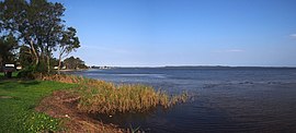
Tuggerah Lake, an intermittently open intermediate wave dominated barrier estuary that is part of the Tuggerah Lakes, is located within the Central Coast Council local government area in the Central Coast region of New South Wales, Australia. The lake is located near Wyong and is situated about 90 kilometres (56 mi) north of Sydney.

Wyong Shire was a local government area located in the Central Coast region of New South Wales, Australia. The incorporation of the Wyong area dates back to 7 March 1906 when the entire area of the Brisbane Water Police District outside of the Town of Gosford was proclaimed as the Erina Shire. From 1 January 1947, local government in the Central Coast region was reorganised, creating Gosford Shire and Wyong Shire, which comprised Erina Shire north and east of Kulnura, Central Mangrove and Lisarow.

Moore Park is a suburb in the Eastern Suburbs of Sydney located 3 kilometres (1.9 mi) from the CBD, in the state of New South Wales, Australia. It is part of local government area of the City of Sydney.

Huskisson is a village in New South Wales, Australia in the City of Shoalhaven, on the shores of Jervis Bay. It is 24 km south-east of Nowra.
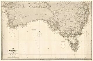
The term Southern Australia is generally considered to refer to the states and territories of Australia of New South Wales, Victoria, Tasmania, the Australian Capital Territory and South Australia. The part of Western Australia south of latitude 26° south — a definition widely used in law and state government policy — is also usually included.
Toukley is a town in the Central Coast region of the Australian state of New South Wales and is located within Central Coast Council. It lies approximately 109 km north of Sydney and 54 km south of Newcastle via the Pacific Motorway (M1). It is located between Tuggerah Lake, Budgewoi Lake, and the Pacific Ocean. At the channel connecting Tuggerah Lake and Budgewoi Lake the new Toukley bridge was constructed between 1983 and 1985 linking Toukley on the eastern side of the Lakes system with Gorokan on the west, replacing the old two lane wooden bridge.

The Entrance is a coastal town and suburb in the Central Coast region of New South Wales, Australia. It is part of the Central Coast Council local government area. At the 2011 census, The Entrance had a population of 3,873 people.

Vincentia is a town in New South Wales, Australia in the City of Shoalhaven, on the shores of Jervis Bay. It is roughly 25 kilometres (16 mi) southeast of Nowra, and approximately 200 kilometres (120 mi) south of Sydney. At the 2016 census, the population of Vincentia was 3,290. It is also a tourist spot with a beach area featuring white sand and a number of motels.
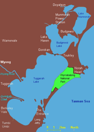
The Tuggerah Lakes, a wetland system of three interconnected coastal lagoons, are located on the Central Coast of New South Wales, Australia and comprise Lake Munmorah, Budgewoi Lake and Tuggerah Lake.

Budgewoi is a coastal town that is located on the Central Coast of New South Wales, Australia. Budgewoi is situated on two peninsulas that is split by the Budgewoi Lake. The town is located about 114 km northeast of Sydney. It is part of the Central Coast Council local government area.

Shelly Beach is a coastal suburb of the Central Coast region of New South Wales, Australia, located east of Tuggerah Lake and bordering the Pacific Ocean south of The Entrance. It is part of the Central Coast Council local government area. It is 66 km south of Newcastle & 93 km north of Sydney. Shelly Beach is considered one of the most popular surfing beaches on the Central Coast.

Tascott is a suburb of the Central Coast region of New South Wales, Australia between Gosford and Woy Woy on Brisbane Water's western shore. It is part of the Central Coast Council local government area.
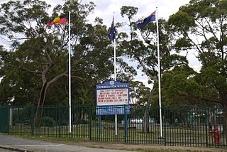
Gorokan High School is a government-funded co-educational dual modality partially academically selective and comprehensive secondary day school, located in Lake Haven, in the Central Coast region of New South Wales, Australia.

The 1994 eastern seaboard fires were significant Australian bushfires that occurred in New South Wales, Australia during the bushfire season of 1993–1994. Some 20,000 firefighters were deployed against some 800 fires throughout the state, and along the coast and ranges from Batemans Bay in the south to the Queensland border in the north, including populated areas of the city of Sydney, the Blue Mountains and the Central Coast. The fires caused mass evacuations of many thousands of people, claimed four lives, destroyed some 225 homes and burned out 800,000 hectares of bushland. The firefighting effort raised in response was one of the largest seen in Australian history.
Blue Haven is a suburb on the Central Coast of New South Wales, Australia, located on Pacific Highway at Wallarah Creek. Its local government area is Central Coast Council.
Somerton is a village between Tamworth and Gunnedah on the Oxley Highway in northern New South Wales Australia. In the 2016 census, there were 277 people in Somerton. Somerton Village adjoins the plentiful Peel River.
The Budgewoi Lake is a lagoon that is part of the Tuggerah Lakes, that is located within the Central Coast Council local government area in the Central Coast region of New South Wales, Australia. The lake is located near the settlement of Budgewoi and is situated about 100 kilometres (62 mi) north of Sydney.
Corindi Beach, pronounced Cor-in-"dye" although Cor-in-"dee" is widely used recently, historically also known as Pipeclay Beach until a name change in 1954, Corinda until a forced change to be provided postal service to avoid confusion or by Red Bank as Corindi River was formerly known, is a beach and small seaside farming town located on the Mid North Coast of New South Wales, Australia. The village is situated 33 kilometres (21 mi) north of Coffs Harbour and 50 kilometres (31 mi) south of Grafton. The original village of Corindi is slightly north along the Pacific Highway at Post Office Lane and Casson Close. Corindi means "grey" in local indigenous language referring to the pipeclay on the beach.

The Central Coast Council is a local government area in the Central Coast region of New South Wales, Australia. It is adjacent to the Pacific Highway, Central Coast Highway, the Northern railway line and the Pacific Ocean. The council was formed on 12 May 2016 following the merger of the Gosford City and Wyong Shire Councils.