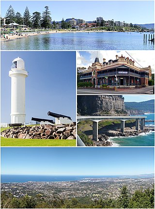
Wollongong, colloquially referred to as The Gong, is a city located in the Illawarra region of New South Wales, Australia. The name is believed to originate from the Dharawal language, meaning either 'five islands/clouds', 'ground near water' or 'sound of the sea'. Wollongong lies on the narrow coastal strip between the Illawarra Escarpment and the Pacific Ocean, 85 kilometres south of central Sydney. Wollongong had an estimated urban population of 302,739 at June 2018, making it the third-largest city in New South Wales after Sydney and Newcastle and the tenth-largest city in Australia by population. The city's current Lord Mayor is Gordon Bradbery AM who was elected in 2021.

Wyong Shire was a local government area located in the Central Coast region of New South Wales, Australia. The incorporation of the Wyong area dates back to 7 March 1906 when the entire area of the Brisbane Water Police District outside of the Town of Gosford was proclaimed as the Erina Shire. From 1 January 1947, local government in the Central Coast region was reorganised, creating Gosford Shire and Wyong Shire, which comprised Erina Shire north and east of Kulnura, Central Mangrove and Lisarow.
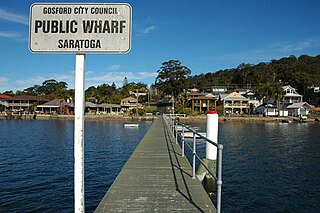
Saratoga is a residential south-eastern village and suburb of the Central Coast region of New South Wales, Australia, located on a peninsula of Brisbane Water and part of the Central Coast Council local government area. The suburb is characterised by its largely settled shoreline, with houses extending up coastal slopes to the base of the tall hills that comprise the core of the peninsula.

Centennial Park is a suburb split between the local government area of the City of Sydney and the City of Randwick, located 4 kilometres (2.5 mi) from the Sydney central business district, in the eastern suburbs of Sydney in the state of New South Wales, Australia.

Paddington is an upscale Eastern Suburb of Sydney, in the state of New South Wales, Australia. Located 3 kilometres (1.9 mi) east of the Sydney central business district, Paddington lies across two local government areas. The portion south of Oxford Street lies within the City of Sydney, while the portion north of Oxford Street lies within the Municipality of Woollahra. It is often colloquially referred to as "Paddo".

Wyoming is a suburb of the Central Coast region of New South Wales, Australia, located 4 kilometres (2 mi) northeast of Gosford's central business district. It is part of the Central Coast Council local government area.
Toukley is a town in the Central Coast region of the Australian state of New South Wales and is located within Central Coast Council. It lies approximately 109 km north of Sydney and 54 km south of Newcastle via the M1. It is located between Tuggerah Lake, Budgewoi Lake, and the Pacific Ocean. At the channel connecting Tuggerah Lake and Budgewoi Lake the new Toukley bridge was constructed between 1983 and 1985 linking Toukley on the eastern side of the Lakes system with Gorokan on the west, replacing the old two lane wooden bridge.

North Bondi is a coastal, eastern suburb of Sydney, in the state of New South Wales, Australia 7 kilometres east of the Sydney central business district, in the local government area of Waverley Council.

Box Hill is a suburb of Sydney, in the state of New South Wales, Australia. Box Hill is located 42 kilometres north-west of the Sydney central business district in the local government area of The Hills Shire and is part of the Hills District region.

Elizabeth Bay is a harbourside inner city eastern suburb of Sydney, in the state of New South Wales, Australia. Elizabeth Bay is located three kilometres east of the Sydney central business district and is part of the local government area of the City of Sydney.
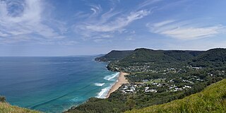
Bald Hill is a hill on the Illawarra Range, in the state of New South Wales, Australia. With an elevation of approximately 300 metres (980 ft) AMSL, Bald Hill is one of the best known and most popular lookouts in the Illawarra region providing panoramic vistas across the Illawarra escarpment and over the Illawarra plain and the Tasman Sea of the South Pacific Ocean.

Canton Beach is a suburb located on the Central Coast of New South Wales, Australia, as part of the Central Coast Council local government area. It is next to Toukley which is a large residential and holiday town.
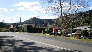
Yarramalong(cedar country) is a township and suburb of the Central Coast region of New South Wales, Australia, located 20 kilometres (12 mi) upstream from Wyong along the Wyong River. It is part of the Central Coast Council local government area.
Calga is a suburb of the Central Coast region of New South Wales, Australia, located 62 kilometres (39 mi) north of Sydney. It is part of the Central Coast Council local government area.
Green Point is a south-eastern suburb of the Central Coast region of New South Wales, Australia between Erina and Kincumber accessed by a main road, Avoca Drive. It is part of the Central Coast Council local government area.

Carrington is a suburb of Newcastle, New South Wales, Australia, and is named after Lord Carrington, governor of New South Wales in 1887 when the area was proclaimed a municipality.

Gunderman is a locality of the Central Coast region of New South Wales, Australia, located on the north bank of the Hawkesbury River between the towns of Wisemans Ferry and Spencer. It is located within the Central Coast Council local government area. It adjoins the Dharug National Park. At the 2006 census, Gunderman had a population of 137 people.

The Hill is an inner city, residential suburb of Newcastle, in the Hunter Region of New South Wales, Australia, located immediately south of Newcastle's central business district. The Hill is filled with historic Victorian terraces and is the site of a historic convict prison block. As of January 2021, the average house price in The Hill was A$1.92m.
Newcastle West is an inner city suburb of Newcastle, New South Wales, Australia, part of which forms the western end of Newcastle's central business district. The suburb is primarily a retail/commercial trading district but includes one high school.
Hargraves House, Noraville is a heritage-listed house at 3 Elizabeth Drive, Noraville in the Central Coast local government area of New South Wales, Australia. It was designed by Edward Hammond Hargraves and built from 1856 to 1859 by Mr Fletcher. It is also known as Hargraves House and Norahville. It was added to the New South Wales State Heritage Register on 2 April 1999.
