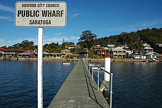
Saratoga is a residential south-eastern village and suburb of the Central Coast region of New South Wales, Australia, located on a peninsula of Brisbane Water and part of the Central Coast Council local government area. The suburb is characterised by its largely settled shoreline, with houses extending up coastal slopes to the base of the tall hills that comprise the core of the peninsula.

Tuggerah is a large commercial hub and a suburb of the Central Coast region of New South Wales, Australia. Tuggerah is situated on the Main North Railway Line and Pacific Motorway, and is located approximately 91 km north of Sydney and 68 km south of Newcastle. It is the second largest business hub, major shopping area and financial district for the Central Coast after Erina.
Lake Haven is a lakeside suburb near Wyong on the NSW Central Coast and is located about 12 kilometres (7.5 mi) north east of the Wyong town centre. It is about 102 km (63 mi) north of Sydney and 53 km (33 mi) south of Newcastle. There is a local shopping and commercial centre that serves the district, with schools and all normal community facilities being available. Rail connections are available in Wyong and at Warnervale, where there is a connection to the M1 freeway.

Shelly Beach is a coastal suburb of the Central Coast region of New South Wales, Australia, located east of Tuggerah Lake and bordering the Pacific Ocean south of The Entrance. It is part of the Central Coast Council local government area. It is 66 km south of Newcastle & 93 km north of Sydney. Shelly Beach is considered one of the most popular surfing beaches on the Central Coast.

Wyong Creek is a suburb of the Central Coast region of New South Wales, Australia. It is part of the Central Coast Council local government area.

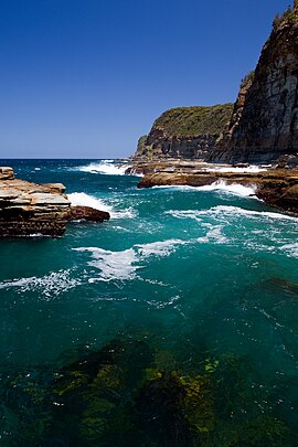
Avoca Beach is a coastal suburb of the Central Coast region of New South Wales, Australia, about 95 kilometres (59 mi) north of Sydney. Avoca Beach is primarily a residential suburb, Avoca Beach is also a popular tourist destination. Avoca Beach is known for its surfing and state (regional) surf competitions. It is located within the Central Coast Council local government area.

Kincumber South is a south-eastern suburb of the Central Coast region of New South Wales, Australia. It is part of the Central Coast Council local government area.

Koolewong is a suburb of the Central Coast region of New South Wales, Australia between Gosford and Woy Woy, and is mostly on a hill overlooking Brisbane Water. It is part of the Central Coast Council local government area.
Mangrove Mountain is a suburb of the Central Coast region of New South Wales, Australia, located about 14 kilometres (9 mi) upstream and north of Spencer along Mangrove Creek.
Marlow is a suburb of the Central Coast region of New South Wales, Australia on the north bank of the Hawkesbury River 58 kilometres (36 mi) north of Sydney. It is part of the Central Coast Council local government area.

Mooney Mooney Creek is a suburb of the Central Coast region of New South Wales, Australia, located 60 kilometres (37 mi) north of Sydney along both sides of the river after which it is named. It is part of the Central Coast Council local government area.

Mount Elliot is a semi-rural locality of the Central Coast region of New South Wales, Australia, 9 kilometres (6 mi) east-north-east of Gosford's central business district. It is part of the Central Coast Council local government area.
North Gosford is a south-eastern suburb of the Central Coast region of New South Wales, Australia immediately north-east of Gosford's central business district. It is part of the Central Coast Council local government area.
Peats Ridge is a suburb in the Central Coast region of New South Wales, Australia, as part of the Central Coast Council local government area.
Picketts Valley is a semi-rural suburb of the Central Coast region of New South Wales, Australia. It is in the Central Coast Council local government area.
Point Clare is a suburb of the Central Coast region of New South Wales, Australia located approximately 75 kilometres (47 mi) north of Sydney and 4 kilometres (2 mi) south-west of Gosford's central business district on the western shore of Brisbane Water. It is part of the Central Coast Council local government area.

Spencer is a suburb of the Central Coast region of New South Wales, Australia. It is located on the north bank of the Hawkesbury River just upstream of that river's confluence with Mangrove Creek. Spencer is part of the Central Coast Council local government area.
Upper Mangrove is a suburb of the Central Coast region of New South Wales, Australia, located about 22 kilometres (14 mi) upstream and north of Spencer along Mangrove Creek. It is part of the Central Coast Council local government area.
Lower Mangrove is a suburb of the Central Coast region of New South Wales, Australia, located about 8 kilometres (5 mi) upstream and north of Spencer along Mangrove Creek. It is part of the Central Coast Council local government area.
Mangrove Creek is a suburb of the Central Coast region of New South Wales, Australia, located about 14 kilometres (9 mi) upstream and north of Spencer along the Mangrove Creek watercourse. It is part of the Central Coast Council local government area.