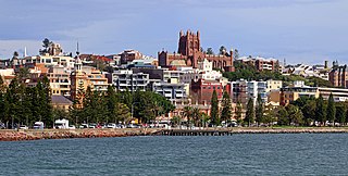
Greater Newcastle is a regional metropolitan area and the second-most-populated district in New South Wales, Australia. It includes the cities of Newcastle and Lake Macquarie; it is the hub of the Lower Hunter region, which includes most parts of the local government areas of City of Newcastle, City of Lake Macquarie, City of Maitland, City of Cessnock and Port Stephens Council.

The Central Coast is a peri-urban region lying on the Pacific Ocean in northern-eastern New South Wales, Australia. The region is situated north of Sydney, which is filled with subtropical national parks, forests and also encompasses the coastal waterways of Brisbane Water, Tuggerah Lakes and southern Lake Macquarie. The region’s hinterland which has fertile valleys, rural farmland and wineries, which also includes the Watagan Mountains. The Central Coast is known for its regional coastal towns like Terrigal, The Entrance, Ettalong Beach, Budgewoi and Bateau Bay with resorts and holiday parks, which does feature many expansive beaches and lagoons with surfing and coastal tracks, as well as scenic views. Gosford is the main commercial centre and gateway.

Bulli is a northern suburb of Wollongong situated on the south coast of New South Wales, Australia.
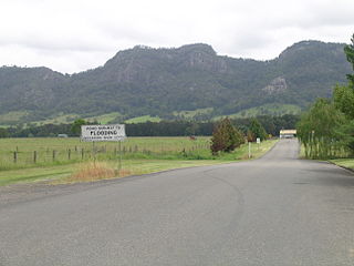
Gloucester, a town in dairy and beef cattle country, is located in Mid-Coast Council, within the Barrington Coast hinterland of the lower Mid North Coast of the state of New South Wales, Australia. It is the closest town to world heritage Barrington Tops National Park.

Central Queensland is an imprecisely-defined geographical division of Queensland that centres on the eastern coast, around the Tropic of Capricorn. Its major regional centre is Rockhampton. The region extends from the Capricorn Coast west to the Central Highlands at Emerald, north to the Mackay Regional Council southern boundary, and south to Gladstone. The region is also known as Capricornia. It is one of Australia's main coal exporting regions.
Wonthaggi is a seaside town located 132 kilometres (82 mi) south east of Melbourne via the South Gippsland and Bass Highways, in the Bass Coast Shire of Gippsland, Victoria, Australia. Known originally for its coal mining, it is now the largest town in South Gippsland, a regional area with extensive tourism, beef and dairy industries.

Catherine Hill Bay is a coastal bay and village on the southern peninsula forming Lake Macquarie, south of the Pacific Ocean entrance channel at Swansea in New South Wales, Australia. It is part of the City of Lake Macquarie local government area. The village is the oldest continuous settlement in the City of Lake Macquarie. The Aboriginal people in this area, the Awabakal were the first people of this land.

Munmorah Power Station is a demolished coal-fired power station with four 350 MW English Electric steam driven turbo-alternators for a combined capacity of 1,400 MW. The station was located near Doyalson, on the shores of Lake Munmorah, New South Wales, Australia and was owned and operated by Delta Electricity, a company owned by the New South Wales Government.
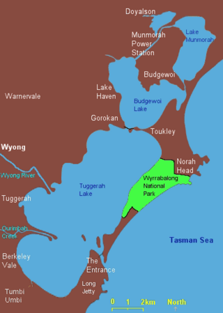
Lake Munmorah or Munmorah Lake, a lagoon that is part of the Tuggerah Lakes, is located within the Central Coast Council local government area in the Central Coast region of New South Wales, Australia. The lake is located near the settlement of Lake Munmorah and is situated about 110 kilometres (68 mi) north of Sydney.

Charmhaven is a suburb of the Central Coast region of New South Wales, Australia. It is part of the Central Coast Council local government area.
Mannering Park is a suburb of the Central Coast region of New South Wales, Australia. It is part of the Central Coast Council local government area. It was formerly called Vales Point.

East Gosford is a suburb of the Central Coast region of New South Wales, Australia, located immediately south-east of Gosford's town centre. It is part of the Central Coast Council local government area, and occupies an area previously inhabited by the Guringai (Wanangine) People. East Gosford is named after the Archibald Acheson, 2nd Earl of Gosford, with whom New South Wales Governor George Gipps served in Canada. Archibald Acheson was appointed Governor of British North America in 1835, and conducted a royal commission into the state of affairs in Lower Canada.
Central Coast Highway is a 50-kilometre (31 mi) highway through the Central Coast region of New South Wales, Australia. It connects Pacific Motorway (M1) at Kariong with Pacific Highway (A43) at Doyalson. The highway was named after the region it goes through, to provide an easily identifiable route for visitors to the region, and is designated route A49.

Scarborough is a small northern seaside suburb of Wollongong on the south coast of New South Wales, Australia. It sits in the northern Illawarra region on a narrow stretch between the Illawarra escarpment and sea cliffs.
Wyee ) is a small town in Greater Newcastle that is located in the City of Lake Macquarie local government area in the Hunter region of New South Wales, Australia. It is near the M1 Pacific Motorway and has a railway station on NSW TrainLink's Central Coast & Newcastle Line. It had a population of 1,487 in 2001, which significantly increased to 2,588 in 2011, and decreased to 2,406 in 2016. Wyee is considered a shanty town and remains highly unchanged since World War II.
Doyalson North is a suburb of the Central Coast region of New South Wales, Australia. It is part of the Central Coast Council local government area.
Blue Haven is a suburb on the Central Coast of New South Wales, Australia, located on Pacific Highway at Wallarah Creek. Its local government area is Central Coast Council.

Stratford is a rural locality in the Mid-Coast Council local government area in the Hunter Region of New South Wales, Australia. The largest population centre in the area is the town of Stratford, which is approximately 14 kilometres (9 mi) south of Gloucester and 109 km (68 mi) north of Newcastle. Stratford, which is next to the Avon River, is on Bucketts Way, 66 km (41 mi) from the Pacific Highway, the nearest major highway.
Avondale is a village in New South Wales. It is located just west of Lake Illawarra. At the 2016 census, it had a population of 1,653.
