Bateau Bay, New South Wales

Last updated

Bateau Bay
Central Coast,  New South Wales
Crackneck.png
Crackneck Lookout
Australia New South Wales location map blank.svg
Red pog.svg
Bateau Bay
Bateau Bay, New South Wales
Coordinates 33°22′55″S151°29′06″E / 33.382°S 151.485°E / -33.382; 151.485
Population12,146 (2016 census) [1]
 • Density1,760/km2 (4,560/sq mi)
Postcode(s) 2261
Elevation12 m (39 ft)
Area6.9 km2 (2.7 sq mi)
Location
LGA(s) Central Coast Council
Parish Tuggerah
State electorate(s) The Entrance
Federal division(s) Dobell
Suburbs around Bateau Bay:
Killarney Vale Long Jetty Shelly Beach
Tumbi Umbi Bateau Bay Pacific Ocean
Tumbi Umbi Forresters Beach Pacific Ocean

Bateau Bay is a suburb of the Central Coast region of New South Wales, Australia. [2] It is part of the Central Coast Council local government area. Bateau Bay lies in the area known as Darkinjung to Indigenous Australians. "Bateau" is French for "boat." The suburb was previously known as Boat Harbour but it was changed to the French version as a marketing activity in the 1970s.

Contents

Geography

Bateau Bay is about 6 km south of the town of The Entrance and 17 km northeast of Gosford's central business district. Bateau Bay Beach provides access to Crackneck Point, which is a popular local surfing spot. Crackneck Point Lookout (about 100 metres above sea level) is a short distance from the beach, where there is a large clearing and carpark with information boards and a picnic-barbecue area. It provides views of The Entrance peninsula and north across Tuggerah Lakes.

Wyrrabalong National Park

Part of Bateau Bay is covered by the southern 140 ha section of Wyrrabalong National Park. A feature of the park's coastal cliffs are extensive rock platforms, which are good bases for rock fishing or low tide exploration. Wyrrabalong National Park is a haven for marine, bird, and native wildlife, which include goannas, bandicoots, fantails, and the tawny frogmouth. A 1.6 km walk through Wyrrabalong National Park links Crackneck Point Lookout and Forresters Beach.

Population

According to the 2016 census of Population, there were 12,146 people in Bateau Bay.

Sporting facilities and parks

EDSACC South Fields EDSACC.JPG
EDSACC South Fields

The Entrance District Sporting and Community Centre (EDSACC) is located on The Entrance Road, between Yakalla Street and Eastern Road. The precinct is separated into three areas: EDSACC North Ovals (soccer), EDSACC South Ovals (rugby league), and a Sports Centre that bisects the two. At the very south of the precinct is a golf driving range and a ten-pin bowling centre. EDSACC is home to the Killarney District Soccer Club and The Entrance Tigers Rugby League Club, as well as EDSACC Croquet Club. There are within the suburb fields that allow for playing of rugby league, rugby union, soccer, Australian rules football, softball, baseball, and cricket

EDSACC building has had a number of names in its time and provides tennis courts, indoor basketball courts, and a gymnasium, and was opened in 1979 by the Governor of New South Wales, Sir Roden Cutler.

It was previously the location of The Entrance Airport.

The precinct also has a golf driving range, which was formerly a football field, but was deemed unsafe due to its uneven surface. The home side—The Entrance Bateau Bay Blues—was forced to relocate to a field on Mingara's property at Tumbi Umbi. The Blues have since resettled at Eastern Road Oval in Killarney Vale.

Pat Morley Oval, located on Cresthaven Avenue, was until the early 1980s a rubbish tip and nightsoil depot and was used as a football oval in the 1990s. Development of a new oval adjacent to the existing Pat Morley Oval was completed in 2010, and is used for cricket and Australian rules football. The Entrance Bateau Bay Blues AFL Club will relocate there in 2011. Central Coast Softball will also use the new ground in the summer season. The main ground is home to The Entrance Bateau Bay United Football Club, the oldest soccer club on the Central Coast, having been established in 1952. [3] Sir Joseph Banks Oval, located behind Cresthaven Shopping Centre, is used by The Entrance Rams Rugby Union club.

Shopping

Stockland Bay Village Stockland Bay Village.JPG
Stockland Bay Village

Bateau Bay Square (formerly known as Stockland Bay Village and Bay Village) is a shopping centre which was opened on the 28th of August 1984,a week after the original planned scheduled opening of August 21st and is operated by Charter Hall. It is mainly tenanted with chain stores with few independent retailers. This piece of land is a new addition to the boundary of Bateau Bay, prior to construction it was included in the boundary of Killarney Vale. It is located next to a Central Coast Shire Council works depot. The centre has removed many retailers and financial services from the existing local areas, creating a questionable positive impact on local shopping. The centre is surrounded by carparks with few pedestrian access routes.

A smaller centre, Cresthaven Shopping Centre opened in 2003. Several other clusters of shops are located throughout Bateau Bay.

Clubs

Bateau Bay Bowling Club Bateau Bay Bowling Club.JPG
Bateau Bay Bowling Club

Bateau Bay Bowling Club is located on the corner of Pheasant Avenue and Bias Avenue. It has TAB facilities, a bar, and a bistro, as well as an undercover carpark. The club has three bowling greens is strong in competitions run statewide.

The Entrance Leagues Club is located on The Entrance Road adjacent to Bateau Bay Square. The club was first opened in 1992. It has over 15,000 members. It features a large carpark as well as an auditorium, TAB facilities, bar and bistro, function rooms, and a members courtesy bus. The Entrance Leagues Club is a major sponsor of The Entrance Tigers Rugby League Club.

The Bateau Bay Hotel is located on The Entrance Road between Lumby Drive and Cresthaven Avenue. Its approval date for building was 4 February, and the day of opening was 8 September, in 1980.

Notable citizens

Schools

Bateau Bay Public School Bateau Bay Public School.JPG
Bateau Bay Public School

There is one school in Bateau Bay: Bateau Bay Public School was established in 1980 and has an enrolment of 739 students in Kindergarten to Year 6. It was originally located in Brooke Avenue (within Killarney Vale) in demountable buildings before relocating. A school remained at Brooke Avenue due to housing development in the period of planning and construction.

Issues

The suburb is bisected by the Entrance Road, a main Central Coast arterial route. There is no differentiation on either side of the Entrance Road; both areas contain housing stock built in the 1960s, '70s, and '80s.

Bateau Bay sewerage treatment plant was built in the late 1960s when at the time there was very little nearby development. Treated sewage is discharged into the sea off Bateau Bay at Wonga Point. Some people protest that sewage may end up on the nearby beaches. There has been no major sea pollution from the plant, there is a smell though over the eastern side of the suburb. [4] The treatment plant has operated for longer than most people have been resident.

Transportation

Red Bus on The Entrance Road Red Bus of Red Bus Services (Bateau Bay, New South Wales, Australia).jpg
Red Bus on The Entrance Road

The Entrance Red Bus Services are the local bus operator and runs several routes through Bateau Bay. The operator's depot is also located at Bateau Bay on Coleridge Road. Routes that operate through Bateau Bay can be found on the Red Bus website.

Related Research Articles

<span class="mw-page-title-main">Gosford</span> City in New South Wales, Australia

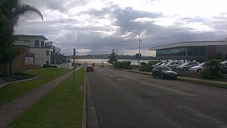
Gosford is a waterfront city at the northern end of Brisbane Water in the heart of the Central Coast in the state of New South Wales, Australia. Gosford is the main commercial hub and gateway of the Central Coast that is known for boating and scenic views along the shore of Brisbane Water and the surrounding valleys. It is situated 77 km (48 mi) north of Sydney and 86 km (53 mi) south of Newcastle as well as 839 km (521 mi) south of Brisbane. Gosford is located in the local government area of the Central Coast Council.

<span class="mw-page-title-main">Craigieburn, Victoria</span> Suburb of Melbourne, Victoria, Australia

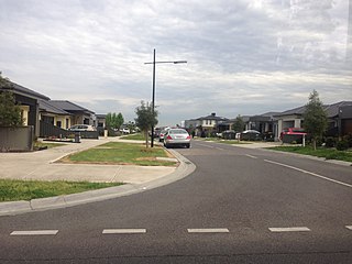
Craigieburn is a suburb in Melbourne, Victoria, Australia, 25 km (16 mi) north of Melbourne's Central Business District, located within the City of Hume local government area. Craigieburn recorded a population of 65,178 at the 2021 census.

<span class="mw-page-title-main">Greenwood, Western Australia</span> Suburb of Perth, Western Australia

Greenwood is a suburb of Perth, Western Australia, located in the City of Joondalup. The suburb is located 18 km from Perth's central business district. It is bordered by the Mitchell Freeway, Hepburn ave, Wanneroo road and Warwick road.

Erina Fair is a large shopping centre in the suburb of Erina on the Central Coast of New South Wales, Australia. Erina Fair is the largest single level shopping centre in the Southern Hemisphere and the largest shopping centre on the Central Coast and in Regional Australia.

<span class="mw-page-title-main">Mona Vale, New South Wales</span> Suburb of Sydney, New South Wales, Australia

Mona Vale is a suburb of Sydney, in the state of New South Wales, Australia. It is located 28 kilometres north of the Sydney central business district, in an area known as the Northern Beaches. Formerly the administrative centre of Pittwater Council, it is now located in the local government area of Northern Beaches Council. The traditional custodians of the area are the Garigal people. It is often colloquially referred to as "Mona".

<span class="mw-page-title-main">Mollymook</span> Town in New South Wales, Australia

Mollymook is a town located on the South Coast of New South Wales, Australia approximately three hours' drive south of Sydney within the City of Shoalhaven local government area. At the 2016 census, Mollymook had a population of 1,083 while the adjacent locality of Mollymook Beach was home to a further 2,447 people. Geographically, Mollymook is considered part of the Milton-Ulladulla district, a coastal corridor of urban development stretching from Burrill Lake, south of Ulladulla to Mollymook's northern neighbour, Narrawallee and the historic town of Milton a few kilometres inland.

<span class="mw-page-title-main">Tumbi Umbi, New South Wales</span> Suburb of Central Coast, New South Wales, Australia

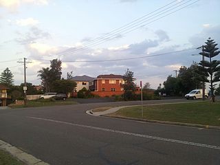
Tumbi Umbi is a mostly semi-rural suburb of the Central Coast region of New South Wales, Australia, located northwest of Bateau Bay along Wyong Road. It is part of the Central Coast Council local government area.

<span class="mw-page-title-main">Cardiff, New South Wales</span> Suburb of Greater Newcastle, New South Wales, Australia

Cardiff is a small town in the Lake Macquarie LGA of New South Wales, Australia.

<span class="mw-page-title-main">Roselands, New South Wales</span> Suburb of Sydney, New South Wales, Australia

Roselands is a suburb to the south-west of the Sydney CBD, in the state of New South Wales, Australia. Roselands is located 16 kilometres south-west of the Sydney central business district in the City of Canterbury-Bankstown. It is one of the easternmost suburbs in the Western Sydney area and is one of the major suburbs in Sydney without a train station.

<span class="mw-page-title-main">Belrose, New South Wales</span> Suburb of Sydney, New South Wales, Australia

Belrose is a suburb of Sydney in the state of New South Wales, Australia 19 kilometres north-east of the Sydney central business district in the local government area of Northern Beaches Council. Belrose is also considered to be part of the Forest District, colloquially known as The Forest.

<span class="mw-page-title-main">Greenacre, New South Wales</span> Suburb of Sydney, New South Wales, Australia

Greenacre is a suburb in South-western Sydney, located 20 kilometres south-west of the Sydney central business district in the state of New South Wales, Australia. Most of Greenacre is in the local government area of the City of Canterbury-Bankstown, while a part in the east is in the Municipality of Strathfield.

<span class="mw-page-title-main">Drummoyne</span> Suburb of Sydney, New South Wales, Australia

Drummoyne is a suburb in the Inner West of Sydney, in the state of New South Wales, Australia. Drummoyne is six kilometres west of the Sydney central business district and is the administrative centre for the local government area of the City of Canada Bay.

<span class="mw-page-title-main">Clovelly, New South Wales</span> Suburb of Sydney, New South Wales, Australia

Clovelly is a small beach-side suburb in Sydney's Eastern Suburbs, in the state of New South Wales, Australia. Clovelly is located 8 kilometres south-east of the Sydney central business district, in the local government area of the City of Randwick, within the Federal Division of Wentworth.

<span class="mw-page-title-main">Umina Beach, New South Wales</span> Suburb of Central Coast, New South Wales, Australia

Umina Beach is a suburb within the Central Coast Council local government area on the Central Coast of New South Wales, Australia. Umina Beach is situated 85 kilometres (53 mi) north of Sydney and 111 kilometres (69 mi) south of Newcastle.

<span class="mw-page-title-main">Warilla, New South Wales</span> Suburb of City of Shellharbour, New South Wales, Australia

Warilla is a seaside suburb of the City of Shellharbour, Australia within the Wollongong urban area. It is one of the more established areas and is between the suburbs of Mount Warrigal in the west, Barrack Heights and Barrack Point in the south and Lake Illawarra in the north.

<span class="mw-page-title-main">Red Bus Services</span> Australian bus company operating route bus services on the New South Wales Central Coast

Red Bus Services is an Australian bus company operating route bus services on the New South Wales Central Coast.

<span class="mw-page-title-main">Toowoon Bay, New South Wales</span> Suburb of Central Coast, New South Wales, Australia

Toowoon Bay is a suburb of the Central Coast region of New South Wales, Australia, located on a peninsula between Tuggerah Lake and the Pacific Ocean south of The Entrance. It is part of the Central Coast Council local government area.

<span class="mw-page-title-main">Forresters Beach</span> Suburb of Central Coast, New South Wales, Australia

Forresters Beach is a coastal suburb of the Central Coast region of New South Wales, Australia between Terrigal and Bateau Bay. It forms part of the Central Coast Council local government area. Forresters Beach's reef breaks are well known to surfers. Its name comes from Robert Forrester who purchased 50 acres (200,000 m2) of land in 1861.

<span class="mw-page-title-main">Concord Oval</span> Rugby stadium in Sydney

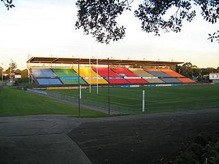
Concord Oval, is a rugby football stadium in the inner-west Sydney suburb of Concord, Australia. The stadium is able to hold 5,000 people as of November 2022, down from 20,000 when the Concord Oval was opened in 1985. As of 2022, it is used mostly for rugby union matches and hosted eight matches during the 1987 Rugby World Cup. It is also a venue for soccer matches and local rugby league matches.

<span class="mw-page-title-main">Figtree, New South Wales</span> Suburb of Wollongong, New South Wales, Australia

Figtree is an inner western suburb of Wollongong, New South Wales, Australia. It is south-west of West Wollongong and connected to Wollongong by the Princes Highway

References

  1. 1 2 Australian Bureau of Statistics (27 June 2017). "Bateau Bay (State Suburb)". 2016 Census QuickStats. Retrieved 18 March 2018. OOjs UI icon edit-ltr-progressive.svg
  2. "Bateau Bay". Destination NSW. Retrieved 17 October 2013.
  3. CCF History. "Clubs". Archived from the original on 19 September 2021. Retrieved 1 October 2022.
  4. "The Sydney Morning Herald - Google News Archive Search".