Hardys Bay, New South Wales

Last updated

Hardys Bay
Central Coast,  New South Wales
Hardys Bay, New South Wales.jpg
Population227 (2016 census) [1]
 • Density252/km2 (650/sq mi)
Postcode(s) 2257
Elevation2 m (7 ft)
Area0.9 km2 (0.3 sq mi)
Location
LGA(s) Central Coast Council
Parish Kincumber
State electorate(s) Terrigal
Federal division(s) Robertson
Suburbs around Hardys Bay:
Killcare
Pretty Beach Hardys Bay Killcare
Box Head

Hardys Bay is a south-eastern suburb of the Central Coast region of New South Wales, Australia on the Bouddi Peninsula. It is part of the Central Coast Council local government area.

Contents

History

Hardys Bay was named after Harry Hardy, who kept a small vineyard and sold wine to local residents. [2] It is home to local shops and cafés, an RSL Club and a marina. The history of Hardys Bay and the surrounding areas of Wagstaffe, Killcare and Pretty Beach are closely linked. Prior to the arrival of European Settlement, Indigenous Australians from the coastal Guringai (Ku-ring-gai) tribe lived in and around Hardys Bay area. Evidence is to be found today in rock carvings and middens found in numerous locations around the area.

On 6 June 1789 Governor Arthur Phillip sailed north and entered Broken Bay and explored the surrounding coastline. [3] The first recorded white settler was a Mr James Mullen (or Mullin) who was granted temporary occupation of 250 acres (1.0 km2) in 1824 for grazing [4] and by the 1829 Census is recorded as having "50 acres (200,000 m2) of land, 10 acres (40,000 m2) cleared, 10 cultivated and having 3 horses and 115 cattle. [5]

In 1859, Captain Daniel Joyce from New Zealand purchased a 50-acre (200,000 m2) grant from Mallen. (This is the land on which the Hardys Bay R.S.L. is currently located.) Joyce subsequently defaulted on his debt which forced the mortgagees to sell his land in Brisbane Waters which was purchased by Mr Robert Hardy, Farmer. [6]

Access to Hardys Bay and the surrounding peninsular was via ferry until 1936 when the Scenic Road was opened. Electricity arrived in 1939 and town water was connected in 1980. [6]

Development

Large scale rutile mining took place over the hill at Putty and Killcare beaches in the 1960s and stripped the beach of its large sand dunes and destroyed many native plants, molluscs and animals. Miners had agreed to revegetate the area which they did with the noxious pest bitou bush ( Chrysanthemoides monilifera ), which the various land care groups are now trying to eradicate. [6]

Over the last 30 years property values in the area have reached into the millions of dollars as it is a prime location for holiday houses and retirement, like many other coastal areas within close proximity of a major city.

Some heritage sites, including the Ferry Masters cottage at Wagstaffe have been illegally demolished and developed despite council attempts to prevents this; prosecution of the developers was unsuccessful due to a technicality. [7]

Marina development

In late 2007 a scheme to develop the existing marina was presented to the community by the Marina's CEO, Michael Sparks. [8] This $13 million development would see the existing marina as well as the historic Hardys Bay wharf replaced by a much larger structure containing: 100 car parks over the water; an increase in the number of berths from 23 to 100; additional retail, cafe and restaurant space; as well as providing a 7-day a week boat maintenance facility. [9] Additionally, any applications for new or upgraded marinas must include the provision of a 24-hour sewerage pump-out facility. [10]

Sparks also advised that this marina project application would circumvent the local council approval process and use what is called the Part 3A method of approval. This is a reference to the new provision in the Environmental Planning and Assessment Act which reduces the involvement of the community in the original decision-making process. The decision makers for applications made by marinas under this law are the Minister for Planning and Director General, Department of Planning. [11] While the developers maintain that there will be little environmental impact, a stand of Grey Mangroves ( Avicennia marina ) will have to be removed to make way for the structure, and degradation of the beds of sea grasses is also possible.

Following a presentation to the Hardys Bay Resident Group on 19 February 2008 by Sparks, the group rejected the redevelopment plan. [11] In March 2008, the Wagstaffe to Killcare Community Association also announced that they could not support the current proposal. [12] In early 2008 the plan was rejected by the Department of Planning after numerous complaints from as far away as Slovenia.

Notable residents

Related Research Articles

<span class="mw-page-title-main">Avalon Beach, New South Wales</span> Suburb of Sydney, New South Wales, Australia

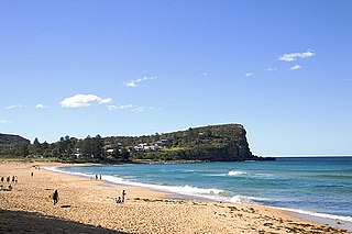
Avalon Beach is a northern beachside suburb of Sydney, in the state of New South Wales, Australia. It is 37 kilometres north of the Sydney central business district, in the local government area of Northern Beaches Council, in the Northern Beaches region. The area was previously called Avalon, with the name Avalon Beach being assigned during a change in boundaries and names in the Pittwater region in 2012.

<span class="mw-page-title-main">Brisbane Water</span> River in New South Wales, Australia

Brisbane Water is a wave-dominated barrier estuary located in the Central Coast region of New South Wales, Australia. Brisbane Water has its origin at the confluence of the Narara and Coorumbine Creeks, to the south–east of Gosford and travels for approximately 18 kilometres (11 mi) in a southerly direction to its mouth at Broken Bay, about 7 kilometres (4.3 mi) from the Tasman Sea, at Barrenjoey Head. A number of towns and suburbs surround the shores of Brisbane Water, including Blackwall, Booker Bay, Davistown, Empire Bay, Erina, Ettalong Beach, Gosford, Green Point, Hardys Bay, Kilcare, Kincumber, Koolewong, Phegans Bay, Point Frederick, Point Clare, Saratoga, Tascott, Wagstaffe, and Woy Woy. Contained within Brisbane Water is St Huberts Island, Rileys Island, Dunmar Island and Pelican Island; and adjoining the estuary is Brisbane Water National Park to the west and Bouddi National Park to the east. Forming part of the same tidal estuary system is a separate but connected basin, the Kincumber Broadwater, lying to the east of Davistown.

<span class="mw-page-title-main">Port Stephens (New South Wales)</span> Estuarine lake in New South Wales, Australia

Port Stephens, an open youthful tide-dominated drowned-valley estuary, is a large natural harbour of approximately 134 square kilometres (52 sq mi) located in the Hunter and Mid North Coast regions of New South Wales, Australia.

<span class="mw-page-title-main">Cronulla, New South Wales</span> Suburb of Sydney, New South Wales, Australia

Cronulla is a suburb of Sydney, in the state of New South Wales, Australia. Boasting numerous surf beaches and swimming spots, the suburb attracts both tourists and Greater Sydney residents. Cronulla is located 26 kilometres south of the Sydney central business district, in the local government area of the Sutherland Shire.

<span class="mw-page-title-main">Narrabeen</span> Suburb of Sydney, New South Wales, Australia

Narrabeen is a beachside suburb of northern Sydney, New South Wales, Australia, 23 kilometres northeast of the the business district, shared by the local government area of Northern Beaches Council and the Northern Beaches region. The bay was named Broken Bay by James Cook as he sailed past.

<span class="mw-page-title-main">Saratoga, New South Wales</span> Suburb of Central Coast, New South Wales, Australia

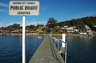
Saratoga is a residential south-eastern village and suburb of the Central Coast region of New South Wales, Australia, located on a peninsula of Brisbane Water and part of the Central Coast Council local government area. The suburb is characterised by its largely settled shoreline, with houses extending up coastal slopes to the base of the tall hills that comprise the core of the peninsula.

<span class="mw-page-title-main">Watsons Bay, New South Wales</span> Suburb of Sydney, New South Wales, Australia

Watsons Bay is a harbourside, eastern suburb of Sydney, in the state of New South Wales, Australia. Watsons Bay is located 11 km north-east of the Sydney central business district, in the local government area of the Municipality of Woollahra.

<span class="mw-page-title-main">Mona Vale, New South Wales</span> Suburb of Sydney, New South Wales, Australia

Mona Vale is a suburb of Sydney, in the state of New South Wales, Australia. It is located 28 kilometres north of the Sydney central business district, in an area known as the Northern Beaches. Formerly the administrative centre of Pittwater Council, it is now located in the local government area of Northern Beaches Council. The traditional custodians of the area are the Garigal people. It is often colloquially referred to as "Mona".

<span class="mw-page-title-main">Ramsgate, New South Wales</span> Suburb of Sydney, New South Wales, Australia

Ramsgate is a suburb in southern Sydney, in the state of New South Wales, Australia 16 km south of the Sydney central business district. It is part of the St George area. Divided by Rocky Point Road, part of Ramsgate to the east of Rocky Point Road is in the local government area of the Bayside Council, whilst properties to the west of Rocky Point Road are in the Georges River Council. Ramsgate Beach is a separate suburb, to the east.

<span class="mw-page-title-main">Burraneer, New South Wales</span> Suburb of Sydney, New South Wales, Australia

Burraneer is a bayside suburb in southern Sydney, in the state of New South Wales, Australia. Burraneer is 26 kilometres south of the Sydney central business district, in the local government area of the Sutherland Shire.

<span class="mw-page-title-main">Blakehurst, New South Wales</span> Suburb of Sydney, New South Wales, Australia

Blakehurst is a suburb in southern Sydney, in the state of New South Wales, Australia 18 kilometres south of the Sydney central business district, in the local government area of the Georges River Council. It is part of the St George area.

<span class="mw-page-title-main">Toowoon Bay, New South Wales</span> Suburb of Central Coast, New South Wales, Australia

Toowoon Bay is a suburb of the Central Coast region of New South Wales, Australia, located on a peninsula between Tuggerah Lake and the Pacific Ocean south of The Entrance. It is part of the Central Coast Council local government area.

<span class="mw-page-title-main">Bouddi, New South Wales</span> Suburb of Central Coast, New South Wales, Australia

Bouddi is a coastal south-eastern suburb of the Central Coast region of New South Wales, Australia. It is in the Central Coast Council local government area. Bouddi is the Aboriginal word for the heart.

<span class="mw-page-title-main">Killcare, New South Wales</span> Suburb of Central Coast, New South Wales, Australia

Killcare is a south-eastern suburb of the Central Coast region of New South Wales, Australia, located on the Bouddi Peninsula. It is part of the Central Coast Council local government area.

<span class="mw-page-title-main">Killcare Heights, New South Wales</span> Suburb of Central Coast, New South Wales, Australia

Killcare Heights is a south-eastern suburb of the Central Coast region of New South Wales, Australia on the Bouddi Peninsula. It is part of the Central Coast Council local government area.

<span class="mw-page-title-main">Wagstaffe, New South Wales</span> Suburb of Central Coast, New South Wales, Australia

Wagstaffe is a south-eastern suburb of the Central Coast region of New South Wales, Australia on the Bouddi Peninsula. It is part of the Central Coast Council local government area. It was named after Captain Wagstaffe, one of the first settlers in the area. It has a general store, which is also the local post office. It is a thin slither of around 200 houses between the bay and the bush(Bouddi National Park). Historically it was also known as Wagstaffe Point. In aboriginal dialect the point is called Kourang Gourang. A ferry service operates between Wagstaffe and Palm Beach(via Ettalong). Travel time is 30 minutes.

<span class="mw-page-title-main">Obelisk Beach</span>

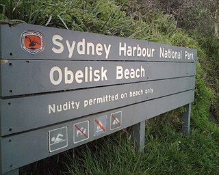
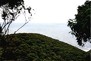
Obelisk Beach is a nude beach in Mosman, New South Wales, Australia.

<span class="mw-page-title-main">Freshwater, New South Wales</span> Suburb of Sydney, New South Wales, Australia

Freshwater is a suburb of northern Sydney, in the state of New South Wales, Australia. Freshwater is located 17 kilometres (11 mi) north-east of the Sydney central business district, in the local government area of Northern Beaches Council and is part of the Northern Beaches region.

<span class="mw-page-title-main">Lugarno, New South Wales</span> Suburb of Sydney, New South Wales, Australia

Lugarno is a suburb situated in the St George area of southern Sydney, in the state of New South Wales, Australia. It is located in the local government area of the Georges River Council, 23 kilometres south of the Sydney central business district.

References

  1. Australian Bureau of Statistics (25 October 2007). "Hardys Bay (State Suburb)". 2006 Census QuickStats. Retrieved 24 October 2013.
  2. Gosford City Library. "Placenames". Archived from the original on 29 August 2007. Retrieved 21 July 2007.
  3. Clark, Manning (2000). A History of Australia, Vol.1. Melbourne, Australia: Melbourne University Press. ISBN   0-522-84008-6.
  4. Colonial Secretary's Papers. Sydney, New South Wales: NSW Government. 1826. pp. 153, 228.
  5. Colonial Secretary (1845). Blue Books, 1845. Sydney, New South Wales: NSW Government. pp. 376–377.
  6. 1 2 3 Baxter, Jillian (2000). Reflections from the Beach and Bays. Hardys Bay, New South Wales: Killcare Progress Association. ISBN   0-646-40502-0.
  7. "Peninsula News, 16/07/2002". Archived from the original on 29 July 2008.
  8. Alison Branley (6 February 2008). "Owners Eager to Expand Marina". Express Advocate.
  9. "Killcare Marina".
  10. "REPORT OF THE COASTLINE MANAGEMENT, LAGOON MANAGEMENT AND COASTAL PLANNING COMMITTEE (CLP COMMITTEE) (840.11.01) Held on 3 September 2001" (PDF). Archived from the original (PDF) on 19 July 2005.
  11. 1 2 "Hardys Bay Residents Group".
  12. "Talking Turkey". March 2008.
  13. Show based on local childhood, Peninsula News, 4 May 2009. Retrieved 14 March 2011

Further reading

33°31′23″S151°21′22″E / 33.523°S 151.356°E / -33.523; 151.356