The Central Coast is a peri-urban region lying on the Pacific Ocean in northern-eastern New South Wales, Australia. The region is situated north of Sydney, which is filled with subtropical national parks, forests and also encompasses the major coastal waterways of Brisbane Water, Tuggerah Lakes and southern Lake Macquarie. The region's hinterland, which has fertile valleys, rural farmland and wineries, and also includes the Watagan Mountains. The Central Coast is known for its regional coastal towns like Terrigal, The Entrance, Ettalong Beach, Budgewoi and Bateau Bay with resorts and holiday parks, which feature many expansive beaches and lagoons with surfing and coastal tracks, as well as scenic views. Gosford is the main commercial hub and gateway.
Stockton is a suburb of Newcastle, New South Wales, Australia, located 600 m (0.4 mi) from Newcastle's central business district. It is the only residential suburb of the City of Newcastle that lies north of the Hunter River.
Bateau Bay is a suburb of the Central Coast region of New South Wales, Australia. "Bateau" is French for "boat."

The Entrance is a coastal town in the Central Coast region of New South Wales, Australia. It is part of the Central Coast Council local government area. At the 2021 census, The Entrance had a population of 4,244 people.

Little Bay is a suburb in the Eastern Suburbs of Sydney, in the state of New South Wales, Australia. Little Bay is located 14 kilometres south-east of the Sydney central business district and is part of the local government area of the City of Randwick.

Tamarama is a beachside suburb, eastern suburb of Sydney, in the state of New South Wales, Australia. Tamarama is 6 kilometres east of the Sydney central business district, in the local government area of Waverley Council.

Clovelly is a small affluent beach-side suburb in Sydney's Eastern Suburbs, in the state of New South Wales, Australia. Clovelly is located 8 kilometres south-east of the Sydney central business district.

Kanwal is a suburb just west of the Tuggerah Lake on the Central Coast, New South Wales, Australia. It is part of the Central Coast Council local government area and is approximately nine kilometres north east of Wyong and six kilometres west of the Pacific Ocean.

Tuggerah railway station is located on the Main Northern line in New South Wales, Australia. It serves the northern Central Coast suburb of Tuggerah, opening in 1890. A pair of passing loops were added north of the station in 1948. These were removed in December 1995. The station was rebuilt in the 1990s.

Ourimbah railway station is a heritage-listed railway station located on the Main Northern line in New South Wales, Australia. It serves the northern Central Coast suburb of Ourimbah opening on 15 August 1887. The station had passing loops and a freight yard that were removed in March 1993.

Gosford railway station is located on the Main Northern line in New South Wales, Australia. It serves the Central Coast city of Gosford, opening on 15 August 1887.
Tuggerah is a large commercial hub and a suburb of the Central Coast region of New South Wales, Australia. It is located approximately 91 km north of Sydney and 68 km south of Newcastle. It is the second largest business hub, major shopping area and financial district for the Central Coast after Erina.

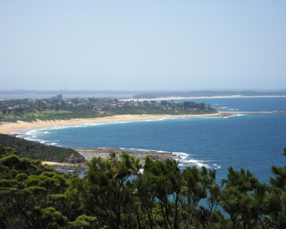
Long Jetty is a suburb of the Central Coast region of New South Wales, Australia, located on a peninsula between Tuggerah Lake and the Pacific Ocean south of The Entrance. It is part of the Central Coast Council local government area.
Blue Bay is a location of The Entrance district within the Central Coast region of New South Wales, Australia, located on a peninsula between Tuggerah Lake and the Pacific Ocean south of The Entrance. It is part of the Central Coast Council local government area.

Killarney Vale is a suburb of the Central Coast region of New South Wales, Australia, located approximately 5 kilometres south of The Entrance. It is part of the Central Coast Council local government area.

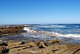
Shelly Beach is a coastal suburb of the Central Coast region of New South Wales, Australia, located east of Tuggerah Lake and bordering the Pacific Ocean south of The Entrance. It is part of the Central Coast Council local government area. It is 66 km south of Newcastle & 93 km north of Sydney. Shelly Beach is considered one of the most popular surfing beaches on the Central Coast.
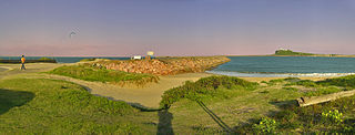
The Entrance North is a coastal village in The Entrance District of the Central Coast region of New South Wales, Australia. It is at the end of a peninsula with Tuggerah Lake to the west and the Tasman Sea to the east. To the south is The Entrance Channel in which flows Tuggerah Lake and on the southern shore is The Entrance. Crossing the channel by foot or road is via The Entrance Bridge. It is part of the Central Coast Council local government area.

Surf Life Saving Australia (SLSA) is an Australian not-for-profit community organisation that promotes water safety and provides surf rescue services.

Park Beach is a suburb of Coffs Harbour, northern New South Wales, located in the north eastern part of the town. It has a population of around 5,000 which swells during summer as it is a coastal tourist destination containing many motels, backpackers and other forms of accommodation. The suburb of Park Beach is generally considered to be the area within the Ocean Parade and Orlando Street intersection at the south, the Orlando Street and Woolgoolga Road intersection, the turnoff from the Pacific Highway onto Macauleys Headland Drive, and the southern end of the Coffs Coast Regional Park.